How Many Square Miles Is Iceland? (2026 Data)
Iceland's size in square miles and acres, its length, width and coastline, how much is glacier, lowland and forest, its lakes, rivers and mountains, and how far it is to drive around.
- Published
- Updated
- 31 sources
- 195 statistics
- 11 min read

- M.Sc. in Atmospheric Sciences, University of Iceland (Háskóli Íslands), with a minor thesis on North Atlantic storm-track variability
- Former research assistant at the Icelandic Meteorological Office (Veðurstofa Íslands), working on subarctic climate modeling and volcanic-ash dispersion forecasting
- B.A. in Sociology, also from the University of Iceland, with fieldwork on rural depopulation and tourism's impact on small fishing communities (Westfjords focus)
- Grew up in Akureyri, spent seven years living in Reykjavík and two in a small village in the Westfjords - brings first-hand experience of Iceland's regional weather extremes and community life
- Fluent in Icelandic and English; has translated Icelandic Met Office public advisories for international outlets
- Published field notes and data-driven pieces on glacier retreat (Vatnajökull), aurora forecasting, and the socioeconomic effects of overtourism in the Golden Circle

- M.A. in Journalism, University of Iceland, with additional coursework in Environmental Communication at the University of Bergen (Norway), giving a comparative Nordic lens
- 12+ years in Icelandic media, including editorial roles at RÚV (Iceland's national broadcaster) covering weather-related public safety reporting (storms, volcanic eruptions, road closures)
- Former fact-checking lead for a travel-and-culture desk, specializing in verifying tourism statistics, safety advisories, and climate data against primary sources (Vedur.is, Statistics Iceland)
- Has overseen editorial standards for bilingual (Icelandic/English) publications, ensuring both cultural nuance and accuracy for international readers
- Advocate for citing primary sources (Icelandic Met Office, Icelandic Tourist Board / Ferðamálastofa) rather than secondhand reporting
Key findings
- 39,769 square milesIceland covers about 39,769 square miles (103,000 km²), according to Statistics Iceland.
- 98%Iceland is about 98% the size of Kentucky, which covers 40,408 square miles.
- 11.6%Glaciers cover 11.6% of Iceland in the official land-cover table, and about 10% by 2019.
- 849 square milesIceland's glaciers have shrunk by about 849 square miles (2,200 km²) since around 1890.
- 36.6%More than a third of Iceland, 36.6%, lies higher than 1,969 feet (600 m) above sea level.
- 21 timesGreenland is about 21 times bigger than Iceland, though its ice-free land is only 4 times bigger.
- 0.52%Forest covered 0.52% of Iceland's land in 2022, against 11.5% in Ireland and 33.5% in Norway.
- 47%About 47% of Iceland's 8,047 miles of national roads were paved in 2023.
Iceland is a little smaller than Kentucky, yet it holds Europe's largest glacier by volume,1 a coastline of 3,783 miles2 in the official table, and a sea area within its fishing limits about 7.4 times3 the size of the land. Only about a quarter2 of the country lies below 656 feet (200 m), where nearly all settlement lies,4 while more than a third rises above 1,969 feet.
Size shapes almost everything a visitor meets: how long the drive around the island takes, how much of it is ice, rock or grass, and why 63.9%5 of residents live in a capital region that covers about 1%6 of the land. This report brings together Statistics Iceland's geographical tables, the Icelandic Institute of Natural History, peer-reviewed glacier research, the World Bank, the US Census Bureau and Iceland's Road and Coastal Administration to measure the country in square miles, miles and acres, with metric figures alongside.
Iceland's size in square miles
Statistics Iceland puts the country's total area at 103,000 km²2, or about 39,769 square miles. The World Bank uses the same total, 103,000 km²7, and lists a land area of 100,830 km²7 (38,931 square miles) once lakes and rivers are taken out. A more detailed measurement by the National Land Survey, now part of the Icelandic Institute of Natural History, drew the coastline at the highest sea level from recent satellite and aerial images. On that line, the mainland covers about 102,593 km²8 (39,611 square miles), and islands larger than one hectare add about 109 km²8 (42 square miles). The same work put the centre of Iceland at 64°59′N, 18°35′W8, in the highlands north of Vatnajökull.
Converted to other units, 103,000 km² equals about 25.45 million acres3 or 10.3 million hectares3, which answers how many acres is Iceland. In square feet, the figure runs to about 1.11 trillion3. Around the land lies a much larger sea area: Iceland's fishing limits enclose 758,000 km²2, about 292,665 square miles.
| Total area | 39,769 | 103,000 | Statistics Iceland; World Bank |
| Land area (without inland water) | 38,931 | 100,830 | World Bank |
| Mainland (National Land Survey coastline) | 39,611 | 102,593 | National Land Survey, 2015 |
| Islands larger than 1 hectare | 42 | 109 | National Land Survey, 2015 |
| Glaciers (land-cover table) | 4,603 | 11,922 | Statistics Iceland |
| Sea area within fishing limits | 292,665 | 758,000 | Statistics Iceland |
| Square miles | 39,769 |
| Square kilometres | 103,000 |
| Acres | 25.45 million |
| Hectares | 10.3 million |
| Square feet | 1.11 trillion |
How many miles long is Iceland?
Iceland's northernmost mainland point is Rifstangi at 66°32.3′ N9 and its southernmost is Kötlutangi at 63°23.6′ N9. That is a span of just over three degrees of latitude, about 217 miles3 (349 km) from north to south. Counting islands, the country reaches from Kolbeinsey at 67°08.9′ N9 to Surtsey at 63°17.7′ N9. The Arctic Circle ran at 66°32.9′ N9 in 2000, just north of Rifstangi, so the mainland lies south of it.
How many miles wide is Iceland?
From Bjargtangar in the west, at 24°32.1′ W9, to Gerpir in the east, at 13°29.6′ W9, Iceland spans about 323 miles3 (519 km) measured along the 65th parallel.
How many miles of coastline does Iceland have?
The answer depends on how finely the shore is traced. Statistics Iceland's geographical table gives 6,088 km2 of coastline, about 3,783 miles or 3,287 nautical miles, while its 2001–2002 yearbook gave 4,970 km10, about 3,088 miles. A National Land Survey engineer notes that any such figure depends on how the shoreline is defined, for example at high or low tide, and on the age of the images used.8
How much does Iceland grow each year?
Iceland sits on the Mid-Atlantic Ridge, where the North American and Eurasian plates pull apart by just under 2 cm11 (about three-quarters of an inch) a year. The spreading is 14–18 mm11 a year in the eastern volcanic zone and only 1–5 mm11 in the western zone. That does not mean the island simply gets bigger: a University of Iceland geologist explains that new lava is roughly balanced by subsidence and erosion by rivers, the sea and glaciers, so the total area stays fairly stable.12
| North (mainland) | Rifstangi | 66°32.3′ N |
| South (mainland) | Kötlutangi | 63°23.6′ N |
| West | Bjargtangar | 24°32.1′ W |
| East (mainland) | Gerpir | 13°29.6′ W |
| North (islands) | Kolbeinsey | 67°08.9′ N |
| South (islands) | Surtsey | 63°17.7′ N |
| East (islands) | Hvalbakur | 13°16.6′ W |
Iceland compared with US states and European countries
In US terms, Iceland falls between Kentucky and Indiana. The Census Bureau puts Kentucky's total area at 40,408 square miles13, so Iceland is about 98%3 of its size, while Indiana covers 36,420 square miles13. Virginia, at 42,77513, and Tennessee, at 42,14413, are slightly larger. Texas, at 268,596 square miles13, could hold Iceland about 6.8 times3.
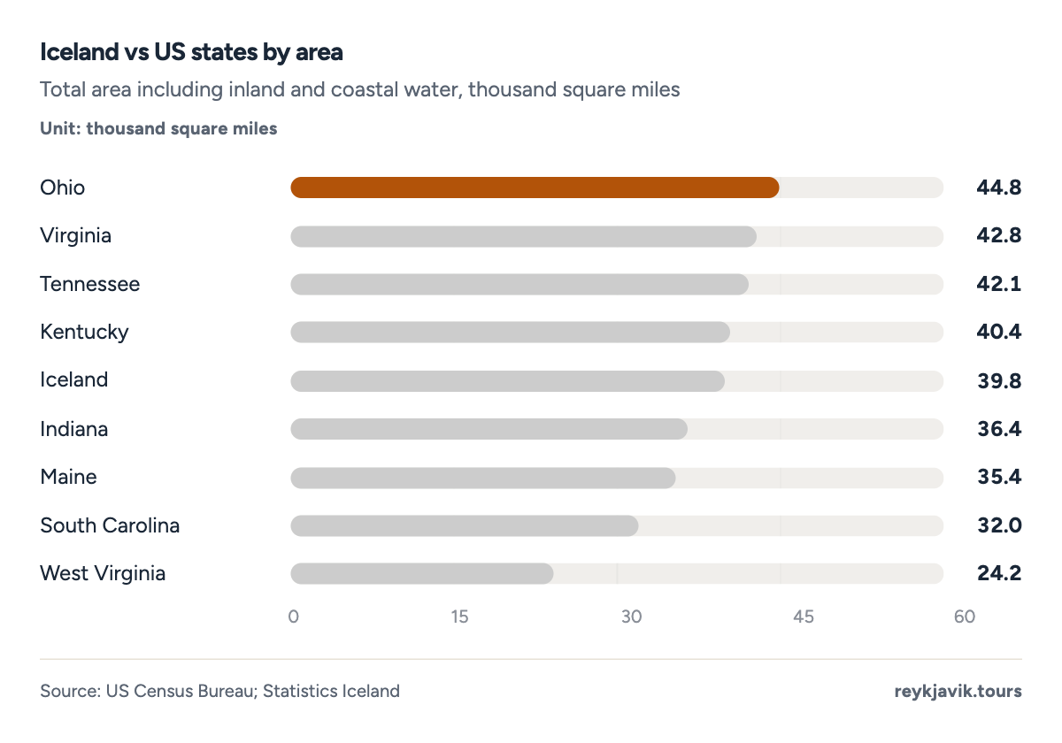
- Iceland covers 39,769 square miles.
- Kentucky covers 40,408 square miles.
| 1 | Texas | 268,596 | 695,662 | 15 |
| 2 | Montana | 147,040 | 380,831 | 27 |
| 3 | Ohio | 44,826 | 116,098 | 89 |
| 4 | Virginia | 42,775 | 110,787 | 93 |
| 5 | Tennessee | 42,144 | 109,153 | 94 |
| 6 | Kentucky | 40,408 | 104,656 | 98 |
| 7 | Indiana | 36,420 | 94,326 | 109 |
| 8 | Maine | 35,380 | 91,633 | 112 |
| 9 | South Carolina | 32,020 | 82,933 | 124 |
| 10 | West Virginia | 24,230 | 62,756 | 164 |
| 11 | Iceland | 39,769 | 103,000 | 100 |
Among European countries, Iceland is mid-sized. By the World Bank's surface-area figures it is less than half the size of the United Kingdom, which covers 243,610 km²7 (94,058 square miles), and about a sixth of Norway, at 624,500 km²7. It is larger than Hungary, Portugal, Austria and Ireland, which covers 70,280 km²7 (27,135 square miles), and more than twice the size of Denmark.
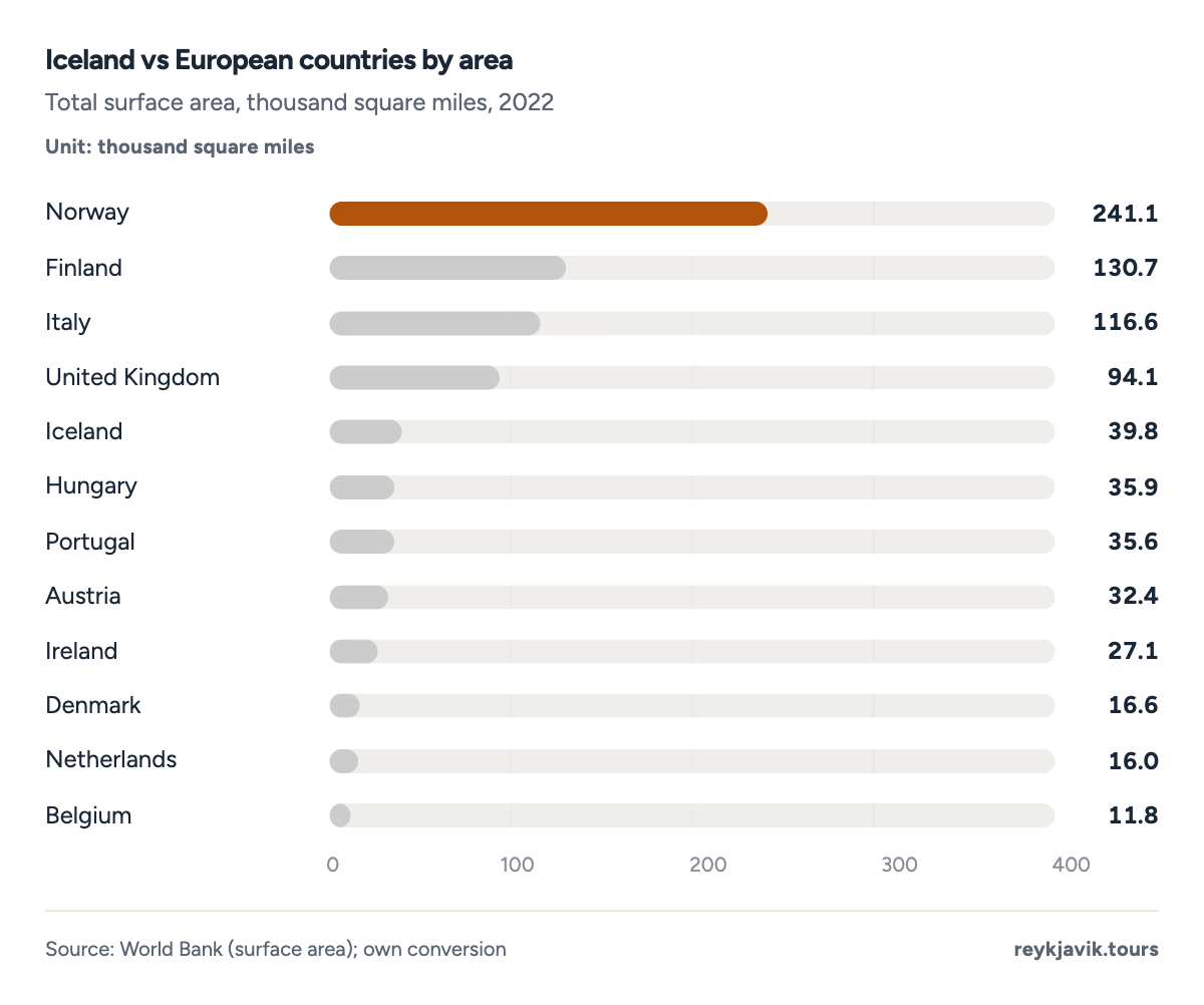
- Iceland covers 39,769 square miles.
- The UK covers 94,058 square miles.
| 1 | Norway | 241,121 | 624,500 | 16 |
| 2 | Finland | 130,684 | 338,470 | 30 |
| 3 | Italy | 116,630 | 302,070 | 34 |
| 4 | United Kingdom | 94,058 | 243,610 | 42 |
| 5 | Iceland | 39,769 | 103,000 | 100 |
| 6 | Hungary | 35,919 | 93,030 | 111 |
| 7 | Portugal | 35,610 | 92,230 | 112 |
| 8 | Austria | 32,386 | 83,879 | 123 |
| 9 | Ireland | 27,135 | 70,280 | 147 |
| 10 | Denmark | 16,572 | 42,920 | 240 |
| 11 | Netherlands | 16,039 | 41,540 | 248 |
| 12 | Belgium | 11,849 | 30,689 | 336 |
| 13 | Sweden | 204,194 | 528,860 | 19 |
| 14 | Germany | 138,070 | 357,600 | 29 |
| 15 | France | 234,136 | 606,410 | 17 |
| 16 | Spain | 195,359 | 505,978 | 20 |
| 17 | Switzerland | 15,942 | 41,290 | 249 |
How much bigger is Greenland than Iceland?
Statistics Greenland gives its total area as 2,166,086 km²14, about 21.0 times3 the size of Iceland. Most of that is ice: Greenland's ice-free area is 410,449 km²14, still about 4.0 times3 Iceland's total. Statistics Greenland describes Greenland as the largest island in the world14, so the answer to "is Iceland the biggest island?" is no.
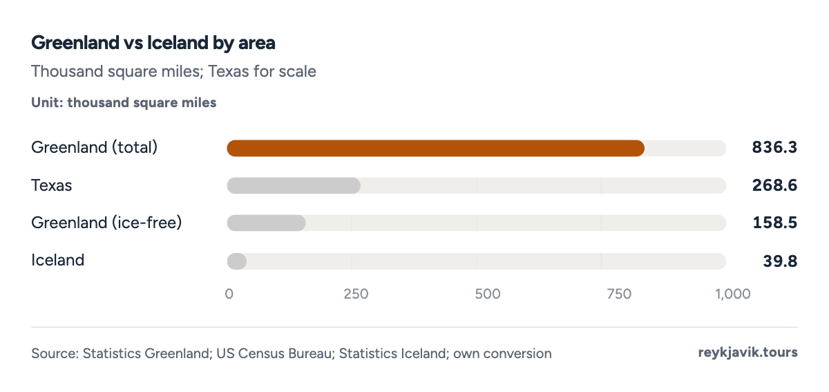
- Greenland covers 836.3 thousand square miles.
- Iceland covers 39.8 thousand.
How much of Iceland is covered by glaciers
Statistics Iceland's land-cover table splits the country's 103,000 km² into four parts. Glaciers take 11,922 km²2, or 11.6%3 of Iceland, about 4,603 square miles; the figure comes from a 1978 survey of glacier area. Vegetated land covers 23,805 km²2 (23.1%) and lakes 2,757 km²2 (2.7%). The largest part, 64,538 km²2 or 62.7%, is classed as wasteland, land with little or no vegetation.
- Wasteland (little or no vegetation)24,91862.6%
- Vegetation9,19123.1%
- Glaciers4,60311.6%
- Lakes1,0642.7%
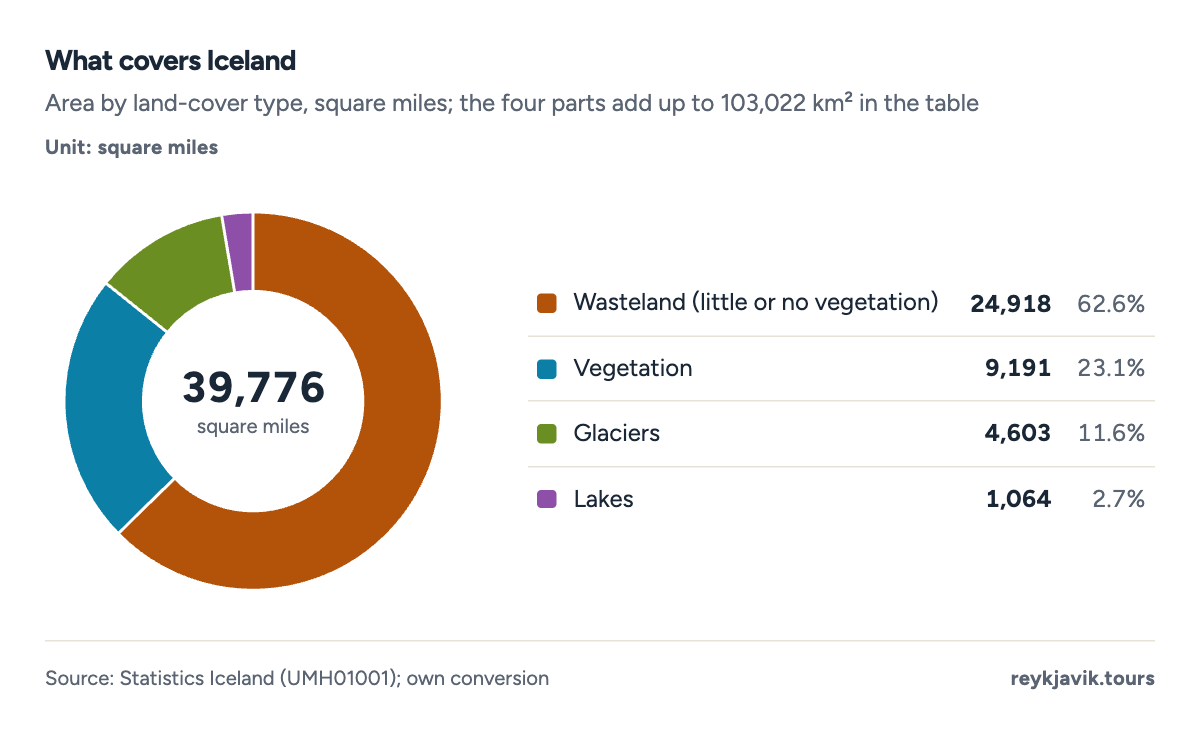
- Glaciers cover 11.6% of the country.
- Vegetation covers 23.1%.
| Wasteland | 24,918 | 64,538 | 62.7 |
| Vegetation | 9,191 | 23,805 | 23.1 |
| Glaciers | 4,603 | 11,922 | 11.6 |
| Lakes | 1,064 | 2,757 | 2.7 |
The ice has shrunk since that survey. Glaciers now cover about 10%15 of Iceland, according to a 2020 peer-reviewed review, which puts the loss since the end of the Little Ice Age, around 1890, at about 2,200 km²15 (849 square miles) and about 750 km²15 (290 square miles) since 2000, roughly 40 km²15 (15 square miles) a year. The underlying study in the journal Jökull put the remaining glacier area at 10,400 km²16 in 2019, 18%16 less than around 1890. Iceland's glaciers held about 3,400 km³15 of ice in 2019, enough to raise global sea level by about 9 mm15 if all of it melted.
Vatnajökull dominates. The Icelandic Institute of Natural History measured it at about 7,600 km²1 (2,934 square miles) in 2023, making it Europe's largest glacier by volume, with about 3,000 km³1 of ice in 2017. Langjökull followed at 820 km²1, Hofsjökull at 795 km²1, Mýrdalsjökull at 510 km²1 and Drangajökull in the Westfjords at 136 km²1. All five are smaller than in Statistics Iceland's older table, which listed Vatnajökull at 8,300 km²2.
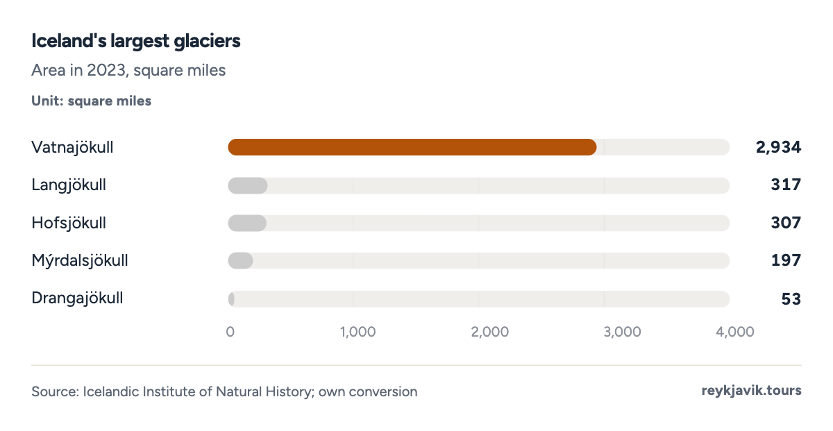
- Vatnajökull covers about 2,934 square miles.
- Drangajökull covers about 53.
| 1 | Vatnajökull | 8,300 | 7,600 | 2,934 | −8 |
| 2 | Langjökull | 953 | 820 | 317 | −14 |
| 3 | Hofsjökull | 925 | 795 | 307 | −14 |
| 4 | Mýrdalsjökull | 596 | 510 | 197 | −14 |
| 5 | Drangajökull | 160 | 136 | 53 | −15 |
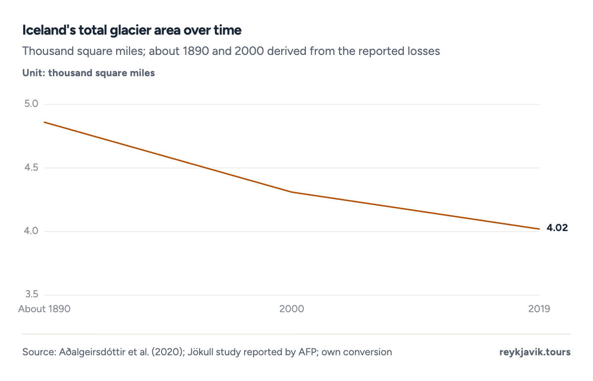
- Glaciers covered about 4,865 square miles around 1890.
- By 2019 they covered about 4,015 square miles.
How much of Iceland is habitable
Height above sea level is the main limit on where people live. National Land Survey figures published by Statistics Iceland show that only 24,700 km²2, about 24%3 of the country, lies below 656 feet (200 m), and a geographer writing for the University of Iceland notes that nearly all settlement is in this lowland band.4 Another 18,400 km²2 lies between 200 and 400 m, and 22,200 km²2 between 400 and 600 m. The largest band, 37,700 km²2 or 36.6%2, is higher than 1,969 feet (600 m). With a volume above sea level of about 50,000 km³12, the average elevation of Iceland works out to about 0.5 km12, roughly 1,640 feet.
- Above 1,969 ft (600 m)14,55636.6%
- Below 656 ft (200 m)9,53724%
- 1,312–1,969 ft (400–600 m)8,57121.6%
- 656–1,312 ft (200–400 m)7,10417.9%
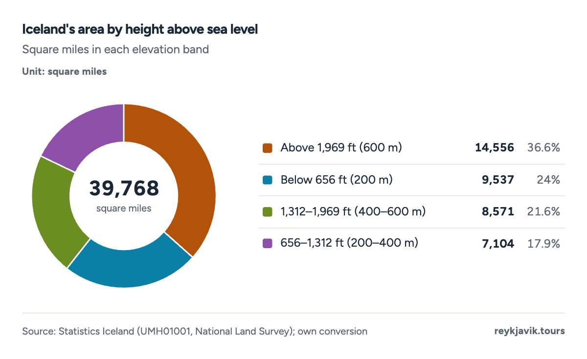
- 36.6% of Iceland lies above 600 m.
- About 24% lies below 200 m.
| Below 656 ft (0–200 m) | 9,537 | 24,700 | 24.0 |
| 656–1,312 ft (201–400 m) | 7,104 | 18,400 | 17.9 |
| 1,312–1,969 ft (401–600 m) | 8,571 | 22,200 | 21.5 |
| Above 1,969 ft (601 m and over) | 14,556 | 37,700 | 36.6 |
Built-up land is a sliver of that lowland. In the land categories Iceland reports under the UN climate convention, settlements covered 454 km²17 (175 square miles) in 2024, about 0.44%3 of the country, up from 307 km²17 in 1990. Grassland is the largest category at 60,265 km²17, followed by other land at 29,495 km²17 and wetlands at 9,576 km²17.
People are even more concentrated than buildings. The seven municipalities of the capital region cover about 1,007 km²6, about 1% of Iceland, yet the region held 63.9%5 of the population in mid-2026. Reykjavík itself covers 273 km²6, so how many square miles is Reykjavik comes to about 105. As for how many municipalities in Iceland there are, Statistics Iceland counted 6218 on 1 January 2026. With about 396,5005 residents, Iceland has about 10.0 people per square mile3 (3.85 per km²); Eurostat ranks its density of 3.8 per km²19 the lowest of 35 European countries.
| 1 | Grassland | 58,684 | 60,265 | 23,268 | +2.7 |
| 2 | Other land | 31,373 | 29,495 | 11,388 | −6.0 |
| 3 | Wetlands | 9,698 | 9,576 | 3,697 | −1.3 |
| 4 | Forest | 963 | 1,573 | 607 | +63.4 |
| 5 | Cropland | 1,357 | 1,018 | 393 | −25.0 |
| 6 | Settlements | 307 | 454 | 175 | +47.8 |
| 1 | Kjósarhreppur | 284 | 109.7 |
| 2 | Reykjavík | 273 | 105.4 |
| 3 | Mosfellsbær | 185 | 71.4 |
| 4 | Hafnarfjörður | 143 | 55.2 |
| 5 | Kópavogur | 80 | 30.9 |
| 6 | Garðabær | 76 | 29.3 |
| 7 | Seltjarnarnes | 2 | 0.8 |
A quarter of the country is also under some form of nature protection. Statistics Iceland recorded 12220 protected areas covering 26,677 km²20 in 2020, about 25.9%3 of Iceland. The three national parks alone covered 15,097 km²20 (5,829 square miles).
| 1 | National parks | 3 | 15,097 | 5,829 |
| 2 | National monuments | 44 | 129 | 50 |
| 3 | Nature reserves | 41 | 3,871 | 1,494 |
| 4 | Habitat protection | 4 | 37 | 14 |
| 5 | Country parks | 23 | 516 | 199 |
| 6 | Areas protected with sectoral laws | 2 | 2,996 | 1,157 |
| 7 | Protected landscape | 2 | 402 | 155 |
| 8 | Master Plan for Nature Protection and Energy | 3 | 3,629 | 1,401 |
Iceland forest cover percentage
Forest is rare. The World Bank, using FAO data, puts Iceland's forest at 0.53%7 of its land area in 2023, up from 0.17%7 in 1990. Iceland's own land-use inventory, which uses its own forest definition, shows forest land growing from 963 km²17 in 1990 to 1,573 km²17 in 2024, a rise of 63%3. Farming land is limited too: the Iceland arable land percentage is 1.2%7, and all agricultural land makes up 16.2%7 of land area.
Projection: linear trend of 1990–2024 yearly values, 95% prediction range. Our calculation, not a forecast.
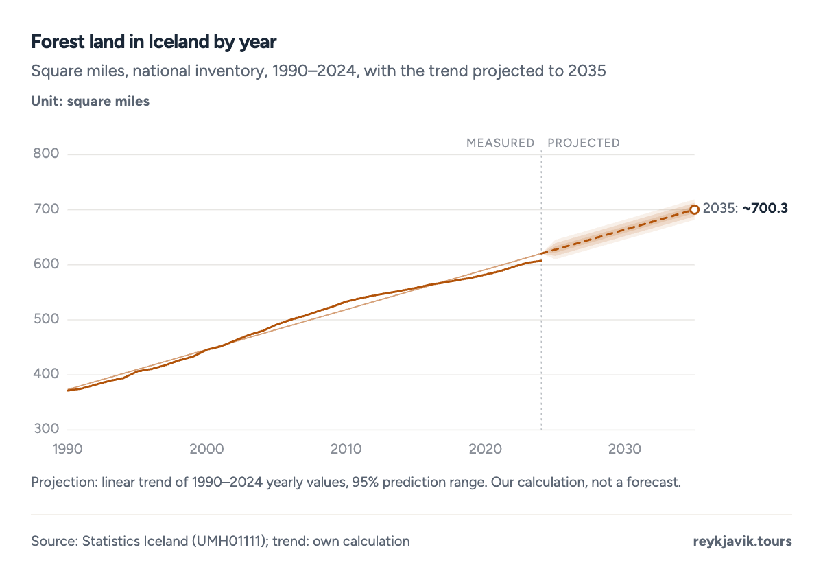
- Forest land covered 371.6 square miles in 1990.
- It covered 607.3 in 2024.
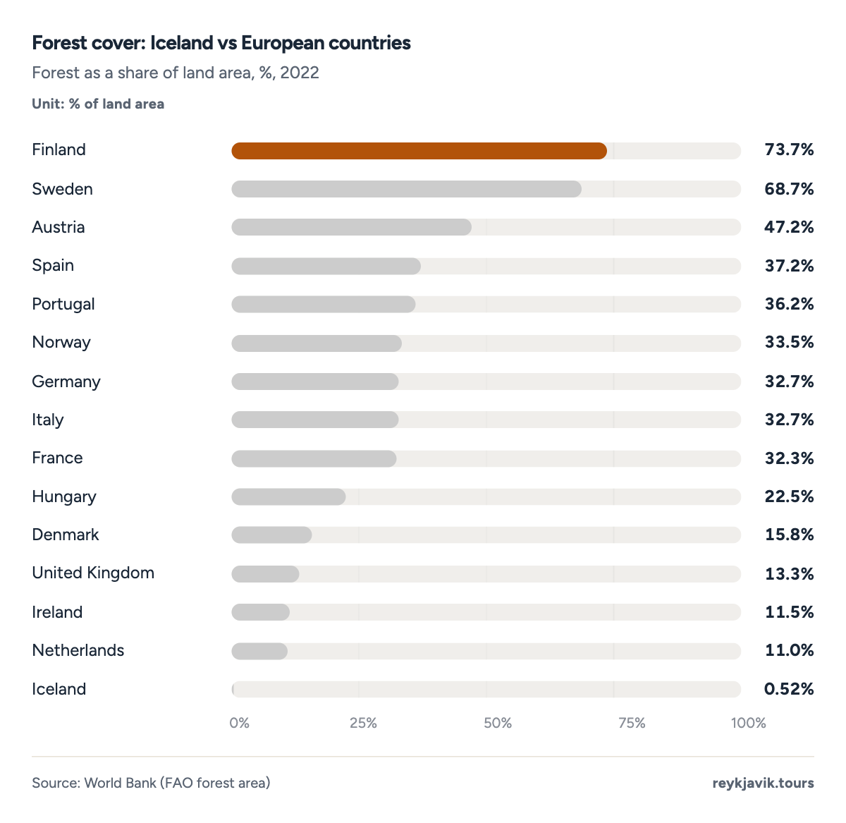
- Finland's land is 73.7% forest.
- Iceland's is 0.52%.
Lakes, rivers, mountains and islands
How many lakes in Iceland?
No official count of lakes was found, but their total area is known: lakes cover 2,757 km²2, about 1,064 square miles. The largest is Þórisvatn, a reservoir whose area varies between 83 and 88 km²2 with the seasons; the Institute of Natural History gives 86 km²21, about 33 square miles. Þingvallavatn, the largest natural lake, covers 83 km²21. Jökulsárlón, the glacier lagoon on the south coast, is the deepest at 248 m21 (814 feet), ahead of Öskjuvatn at 220 m21 (722 feet), a lake formed in 1874–7521.
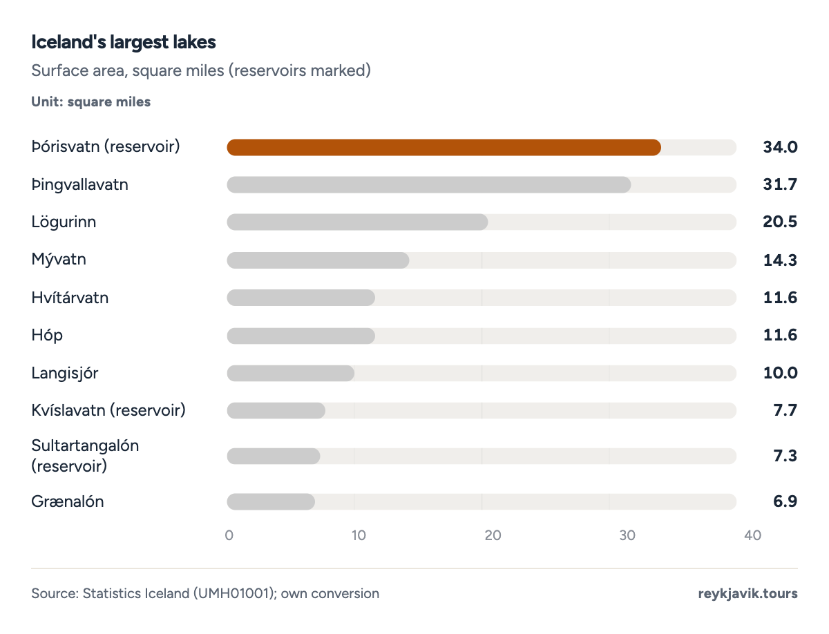
- Þórisvatn covers up to 34.0 square miles.
- Mývatn covers 14.3.
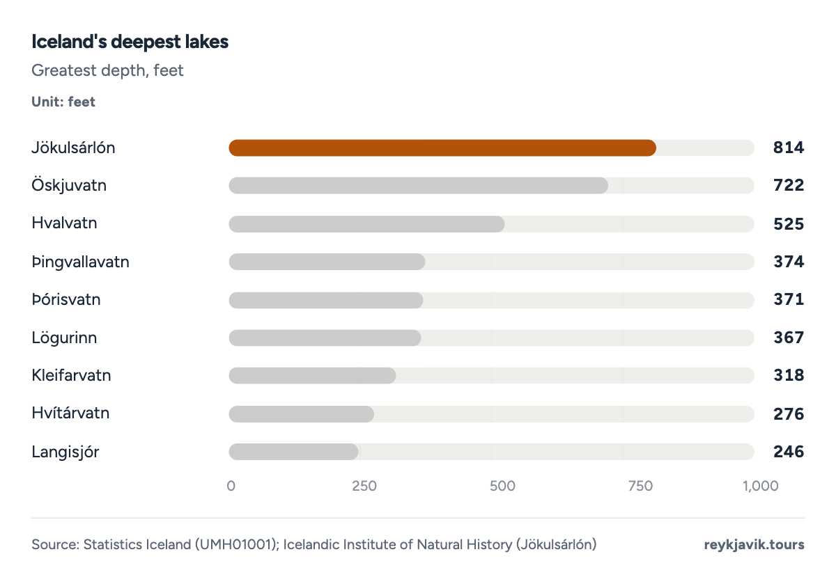
- Jökulsárlón is 814 feet deep.
- Þingvallavatn is 374 feet deep.
| 1 | Þórisvatn (reservoir) | 88 | 34.0 |
| 2 | Þingvallavatn | 82 | 31.7 |
| 3 | Lögurinn | 53 | 20.5 |
| 4 | Mývatn | 37 | 14.3 |
| 5 | Hvítárvatn | 30 | 11.6 |
| 6 | Hóp | 30 | 11.6 |
| 7 | Langisjór | 26 | 10.0 |
| 8 | Kvíslavatn (reservoir) | 20 | 7.7 |
| 9 | Sultartangalón (reservoir) | 19 | 7.3 |
| 10 | Grænalón | 18 | 6.9 |
| 11 | Skorradalsvatn | 15 | 5.8 |
| 12 | Sigöldulón (reservoir) | 14 | 5.4 |
| 13 | Apavatn | 13 | 5.0 |
| 14 | Svínavatn | 12 | 4.6 |
| 15 | Öskjuvatn | 11 | 4.2 |
The longest river is the Þjórsá, 230 km22 or about 143 miles, followed by the Jökulsá á Fjöllum at 206 km22 (128 miles), which drains the largest catchment, 7,750 km²22. Statistics Iceland's table lists the Ölfusá–Hvítá system at 185 km2 and the Skjálfandafljót at 178 km2. Measured by flow, the Ölfusá carries the most water, with a natural mean discharge of 440 m³ a second22.
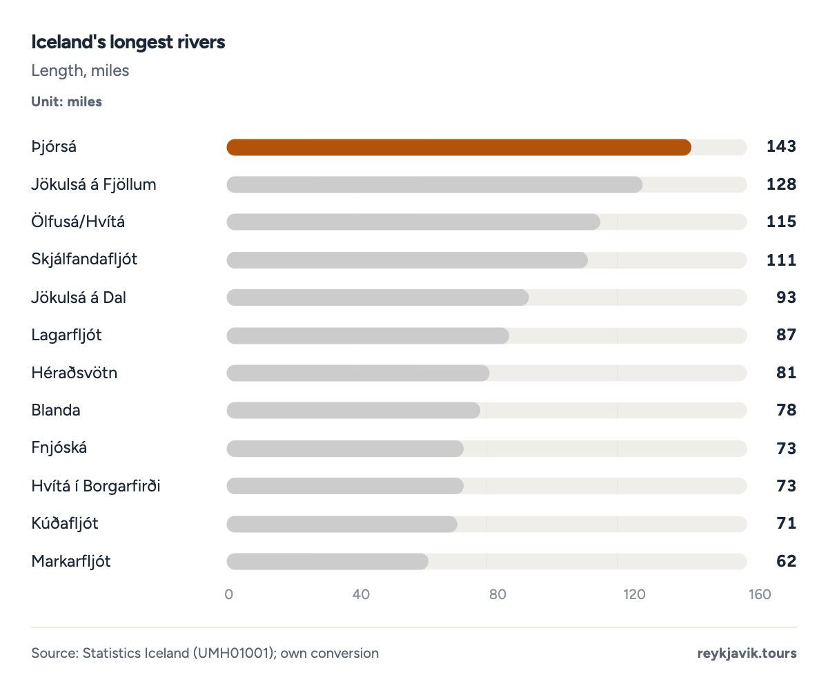
- The Þjórsá is 143 miles long.
- The Jökulsá á Fjöllum is 128 miles long.
| 1 | Þjórsá | 143 | 230 | 2,907 |
| 2 | Jökulsá á Fjöllum | 128 | 206 | 2,992 |
| 3 | Ölfusá/Hvítá | 115 | 185 | 2,355 |
| 4 | Skjálfandafljót | 111 | 178 | 1,490 |
| 5 | Jökulsá á Dal | 93 | 150 | 1,429 |
| 6 | Lagarfljót | 87 | 140 | 1,120 |
| 7 | Héraðsvötn | 81 | 130 | 1,409 |
| 8 | Blanda | 78 | 125 | 915 |
| 9 | Fnjóská | 73 | 117 | – |
| 10 | Hvítá í Borgarfirði | 73 | 117 | 1,371 |
| 11 | Kúðafljót | 71 | 115 | 927 |
| 12 | Markarfljót | 62 | 100 | – |
| 13 | Laxá í Aðaldal (S-Þing.) | 58 | 93 | 830 |
| 14 | Víðidalsá | 57 | 91 | – |
| 15 | Hofsá í Vopnafirði | 53 | 85 | – |
| 16 | Vatnsdalsá | 46 | 74 | – |
| 17 | Hólsá | 44 | 71 | – |
| 18 | Eyjafjarðará | 37 | 60 | – |
| 19 | Skeiðará | 19 | 30 | – |
Biggest mountain in Iceland
The highest summit is Hvannadalshnjúkur, at 2,110 m2 or 6,923 feet. Bárðarbunga reaches 2,000 m2 (6,562 feet), Kverkfjöll 1,920 m2 and Snæfell in the east 1,833 m2 (6,014 feet). Herðubreið rises to 1,682 m2, Hekla to 1,491 m2 and Esja, the mountain seen from Reykjavík, to 914 m2 (2,999 feet). No official count of Iceland's mountains was found.
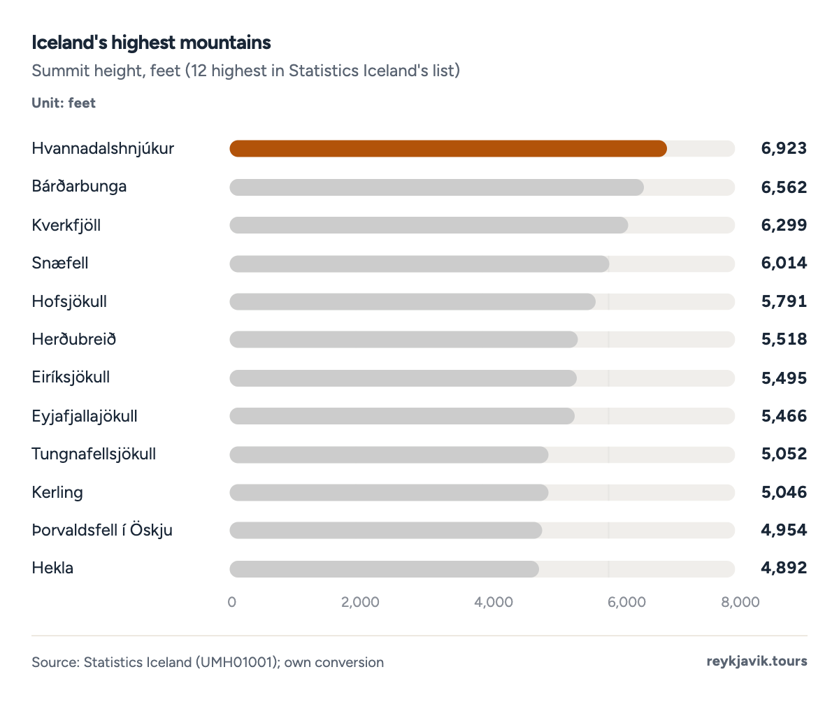
- Hvannadalshnjúkur rises to 6,923 feet.
- Snæfell rises to 6,014 feet.
| 1 | Hvannadalshnjúkur | 6,923 | 2,110 |
| 2 | Bárðarbunga | 6,562 | 2,000 |
| 3 | Kverkfjöll | 6,299 | 1,920 |
| 4 | Snæfell | 6,014 | 1,833 |
| 5 | Hofsjökull | 5,791 | 1,765 |
| 6 | Herðubreið | 5,518 | 1,682 |
| 7 | Eiríksjökull | 5,495 | 1,675 |
| 8 | Eyjafjallajökull | 5,466 | 1,666 |
| 9 | Tungnafellsjökull | 5,052 | 1,540 |
| 10 | Kerling | 5,046 | 1,538 |
| 11 | Þorvaldsfell í Öskju | 4,954 | 1,510 |
| 12 | Hekla | 4,892 | 1,491 |
| 13 | Mýrdalsjökull | 4,856 | 1,480 |
| 14 | Kerlingarfjöll, Snækollur | 4,846 | 1,477 |
| 15 | Tindfjallajökull | 4,797 | 1,462 |
| 16 | Trölladyngja | 4,790 | 1,460 |
| 17 | Snæfellsjökull | 4,744 | 1,446 |
| 18 | Geitlandsjökull í Langjökli | 4,593 | 1,400 |
| 19 | Þórisjökull | 4,429 | 1,350 |
| 20 | Smjörfjöll | 4,104 | 1,251 |
| 21 | Ok | 3,930 | 1,198 |
| 22 | Torfajökull | 3,904 | 1,190 |
| 23 | Kaldbakur í Eyjafirði | 3,829 | 1,167 |
| 24 | Mælifellshnjúkur | 3,734 | 1,138 |
| 25 | Dyrfjöll | 3,727 | 1,136 |
| 26 | Búlandstindur | 3,507 | 1,069 |
| 27 | Skjaldbreiður | 3,478 | 1,060 |
| 28 | Kaldbakur á Vestfjörðum | 3,274 | 998 |
| 29 | Tindastóll | 3,245 | 989 |
| 30 | Baula | 3,064 | 934 |
| 31 | Sjónfríð á Glámu | 3,018 | 920 |
| 32 | Esja | 2,999 | 914 |
| 33 | Klifatindur | 2,913 | 888 |
| 34 | Lómagnúpur | 2,516 | 767 |
Rivers dropping off the highlands form tall waterfalls. Glymur, in the Botnsá river north of Reykjavík, is the highest in Statistics Iceland's list at 190 m2 (623 feet), followed by Háifoss at 122 m2 and Hengifoss at 110 m2. Seljalandsfoss falls 65 m2, Skógafoss 62 m2, Dettifoss 44 m2 and Gullfoss 32 m2.
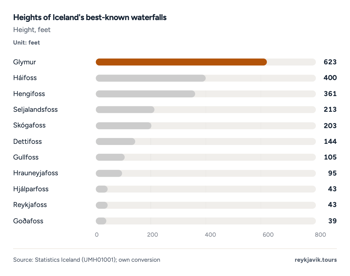
- Glymur drops 623 feet.
- Gullfoss drops 105 feet.
How many islands does Iceland have?
There is no official count. The National Land Survey's measurement found that all islands larger than one hectare, about 2.5 acres, add up to 109 km²8, or 42 square miles. The largest island in Statistics Iceland's list is Heimaey in the Westman Islands, at 13 km²2 (5.0 square miles), followed by Hrísey in Eyjafjörður at 8 km²2. Grímsey, off the north coast, covers 5 km²2, and Surtsey about 2 km²2.
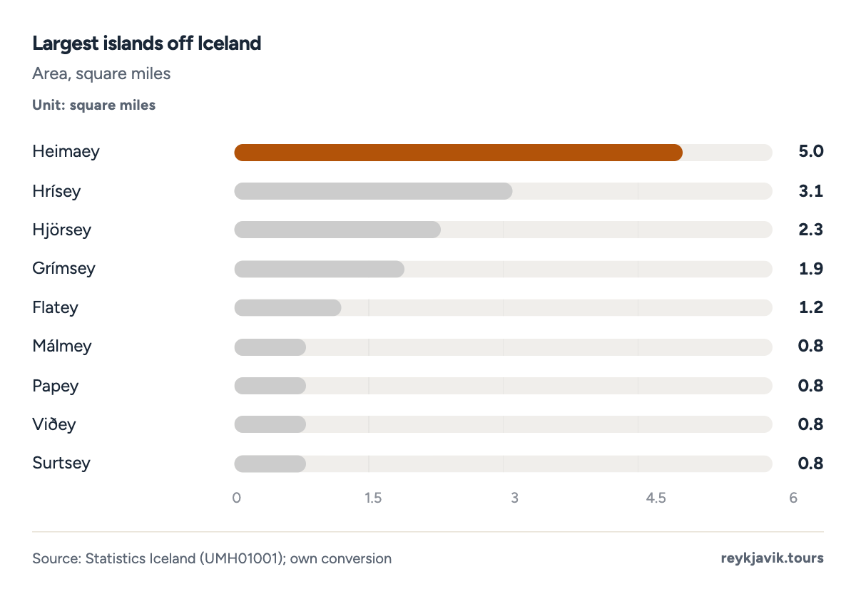
- Heimaey covers 5.0 square miles.
- Grímsey covers 1.9.
How far Iceland is from other places
Greenland is Iceland's nearest neighbour. Statistics Iceland gives the shortest distance between the two coasts as 287 km2, so how many miles from Iceland to Greenland comes to about 178. The Faroe Islands are 420 km2 (261 miles) away, Scotland 798 km2 (496 miles) and Norway 970 km2 (603 miles).
Between cities the distances are longer. By our great-circle calculation, Reykjavík is about 888 miles3 from Nuuk, 929 miles3 from Dublin and 1,174 miles3 from London. For how many miles from New York to Iceland, the straight-line answer from Manhattan to Reykjavík is about 2,611 miles3, and Boston is about 2,4313.
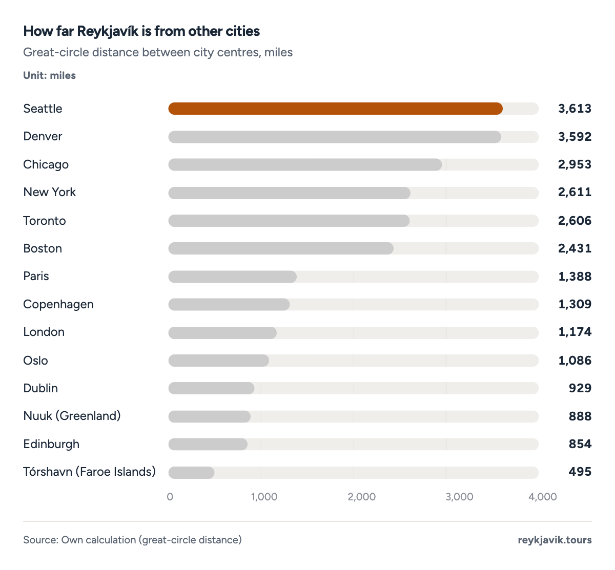
- Nuuk is 888 miles from Reykjavík.
- New York is 2,611 miles away.
| 1 | Greenland | Nearest coast | 178 | 287 |
| 2 | Faroe Islands | Nearest coast | 261 | 420 |
| 3 | Jan Mayen | Nearest coast | 342 | 550 |
| 4 | Scotland | Nearest coast | 496 | 798 |
| 5 | Norway | Nearest coast | 603 | 970 |
| 6 | Tórshavn (Faroe Islands) | From Reykjavík | 495 | 797 |
| 7 | Edinburgh | From Reykjavík | 854 | 1,374 |
| 8 | Nuuk (Greenland) | From Reykjavík | 888 | 1,429 |
| 9 | Dublin | From Reykjavík | 929 | 1,495 |
| 10 | Oslo | From Reykjavík | 1,086 | 1,747 |
| 11 | London | From Reykjavík | 1,174 | 1,890 |
| 12 | Copenhagen | From Reykjavík | 1,309 | 2,107 |
| 13 | Paris | From Reykjavík | 1,388 | 2,233 |
| 14 | Boston | From Reykjavík | 2,431 | 3,913 |
| 15 | Toronto | From Reykjavík | 2,606 | 4,194 |
| 16 | New York | From Reykjavík | 2,611 | 4,203 |
| 17 | Chicago | From Reykjavík | 2,953 | 4,753 |
| 18 | Denver | From Reykjavík | 3,592 | 5,780 |
| 19 | Seattle | From Reykjavík | 3,613 | 5,815 |
How many miles to drive around Iceland
The Ring Road, Route 1, is the usual answer. Its commonly cited length of 1,321 km23 fell by 12 km24 when a new section near Höfn opened on 24 June 2026, which leaves about 813 miles3 (1,309 km). A full loop from Reykjavík on map routing is 828 miles25 and about 20.6 hours25 of driving without stops, and the Golden Circle loop from Reykjavík is 157 miles25. The Road and Coastal Administration says the Ring Road has been fully paved since 201926.
Number of miles of road in Iceland
Statistics Iceland counted 12,950 km27 of national roads in 2023, about 8,047 miles, a total that has barely changed since 2003. Of these, 6,113 km27 (3,798 miles) were paved, 47.2%3 of the network, up from 33.4%3 in 2003. Parliament's 2026 review of the transport plan uses slightly different figures, about 12,900 km28 with 5,961 km28 paved, and counts 1,17428 bridges, of which 63228 are single-lane, including 2928 on the Ring Road at the end of 2024. The Road and Coastal Administration estimates that 97%26 of all traffic runs on paved roads. Paving varies by region: the Southern Peninsula is almost fully paved at 96.9%3, the Northwest only 33.3%3.
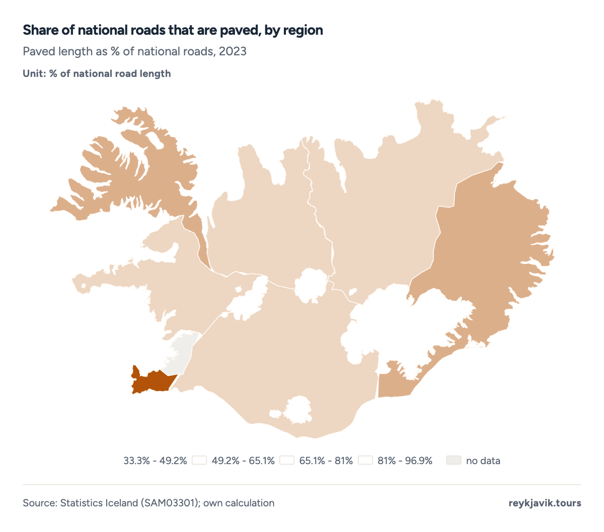
- The Southern Peninsula's roads are 96.9% paved.
- The Northwest's are 33.3% paved.
- Primary roads3,05237.9%
- Secondary roads2,14826.7%
- Local access roads1,64120.4%
- Tertiary (highland) roads1,20515%
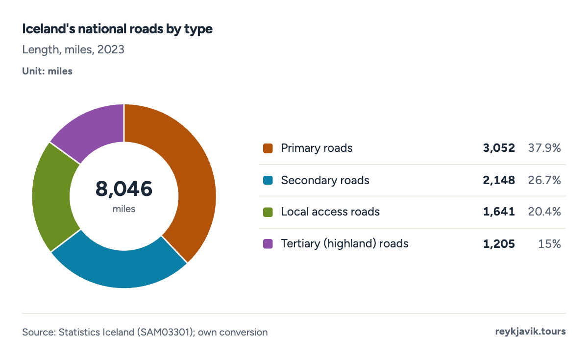
- Primary roads run 3,052 miles.
- Tertiary roads run 1,205 miles.
| 2003 | 8,061 | 2,691 | 33.4 | 19 |
| 2004 | 8,080 | 2,635 | 32.6 | 19 |
| 2010 | 8,008 | 2,837 | 35.4 | 37 |
| 2011 | 8,013 | 3,263 | 40.7 | 37 |
| 2012 | 8,009 | 2,971 | 37.1 | 37 |
| 2016 | 8,013 | 3,463 | 43.2 | 37 |
| 2017 | 8,014 | 3,509 | 43.8 | 50 |
| 2018 | 8,014 | 3,465 | 43.2 | 50 |
| 2019 | 8,013 | 3,494 | 43.6 | 50 |
| 2020 | 8,016 | 3,587 | 44.7 | 57 |
| 2021 | 8,019 | 3,641 | 45.4 | 57 |
| 2022 | 8,042 | 3,782 | 47.0 | 57 |
| 2023 | 8,047 | 3,798 | 47.2 | 57 |
| 1 | Southern Peninsula | 342 | 332 | 96.9 |
| 2 | West | 1,146 | 508 | 44.3 |
| 3 | Westfjords | 874 | 470 | 53.7 |
| 4 | Northwest | 1,077 | 359 | 33.3 |
| 5 | Northeast | 1,388 | 561 | 40.4 |
| 6 | East | 1,133 | 574 | 50.7 |
| 7 | South | 2,086 | 995 | 47.7 |
How many tunnels in Iceland?
The Road and Coastal Administration lists 1229 road tunnels with a combined length of 64 km29, about 40 miles. The longest is Héðinsfjarðargöng in the north, 11 km29 in two sections, and the busiest is Hvalfjarðargöng north of Reykjavík, with 8,76029 vehicles a day in 2024. Vaðlaheiðargöng, near Akureyri, charges a toll. On how much is the toll tunnel in Iceland: a single trip for a car under 3.5 tonnes costs ISK 2,21630 from 2 March 2026, about $1831 at the Central Bank's rate of 15 September 2026.
| 1 | Héðinsfjarðargöng | 2010 | 6.84 | 11,000 | 700 |
| 2 | Vestfjarðagöng (Breiðadals- and Botnsheiði) | 1996 | 5.67 | 9,120 | 790 |
| 3 | Norðfjarðargöng | 2017 | 4.91 | 7,900 | 760 |
| 4 | Vaðlaheiðargöng (toll) | 2018 | 4.66 | 7,500 | 1,700 |
| 5 | Fáskrúðsfjarðargöng | 2005 | 3.67 | 5,900 | 880 |
| 6 | Hvalfjarðargöng | 1998 | 3.59 | 5,770 | 8,760 |
| 7 | Dýrafjarðargöng | 2020 | 3.48 | 5,600 | 365 |
| 8 | Bolungarvíkurgöng | 2010 | 3.36 | 5,400 | 1,150 |
| 9 | Múlagöng | 1990 | 2.11 | 3,400 | 680 |
| 10 | Almannaskarðsgöng | 2005 | 0.81 | 1,300 | 740 |
| 11 | Strákagöng | 1967 | 0.50 | 800 | 325 |
| 12 | Arnardalshamar | 1948 | 0.02 | 30 | 435 |
What the numbers mean
Iceland is compact on a map but large for the number of people who live there. At about 39,769 square miles it is close to Kentucky in size, yet it has about 10.0 people per square mile3, and nearly two-thirds of them live in a capital region of about 1,007 km²6. Most of the rest of the country is ice, bare ground or high plateau: more than a third lies above 1,969 feet, and the official land-cover table classes 62.7%2 as wasteland.
The land itself is changing faster than its outline. Glaciers have lost about 750 km²15 since 2000, while forest land in the national inventory has grown by about 610 km²3 since 1990. For travellers the practical measure is the road network: about 8,047 miles of national roads, of which fewer than half are paved, and a Ring Road of about 813 miles3 that takes about 20.6 hours25 to drive without stops.
Conclusions
- Iceland covers about 39,769 square miles2 (103,000 km²), close to Kentucky, less than half the United Kingdom and about a twenty-first of Greenland; land alone, without lakes and rivers, is 38,931 square miles7.
- How much of Iceland is ice depends on the date. The official land-cover table says 11.6%2, based on a 1978 survey, while recent research puts it at about 10%15, after a loss of about 849 square miles since around 1890.
- Little of Iceland is easy to live on. Only about 24%2 lies below 200 m, settlements take up 0.44%17 of the land, and forest covers 0.53%7 by the World Bank's measure.
- Much of the road network is still unpaved: the Ring Road is about 813 miles3, but only 47.2%27 of the 8,047-mile national network was paved in 2023, and 63228 of the bridges on national roads are single-lane.
Methodology
- Area and land cover: official tables
- Land use 1990–2024
- Roads 2003–2023
- Checked Sept 16, 2026
Definition. Total area is the whole country including glaciers, lakes and rivers (103,000 km²); land area excludes inland water. Square miles are the primary unit (1 km² = 0.3861 sq mi), with km² in brackets; heights are in feet with metres.
Data sources. Area, land cover, elevation bands, lakes, rivers, mountains, waterfalls, islands and distances to nearest coasts from Statistics Iceland's geographical table,2 land-use categories,17 protected areas20 and roads27 from Statistics Iceland; glaciers from the Icelandic Institute of Natural History1 and Aðalgeirsdóttir et al. (2020);15 land area and forest from the World Bank;7 US states from the US Census Bureau;13 Greenland from Statistics Greenland;14 extreme points from Vísindavefurinn;9 tunnels from Vegagerðin.29
Calculations. Unit conversions use 1 mile = 1.609344 km and 1 foot = 0.3048 m. North–south extent is the latitude span × 111.1 km; east–west extent is the longitude span along 65° N. City distances are great-circle distances between city centres. Glacier area around 1890 and in 2000 adds the reported losses to the 2019 area. Shares of Iceland use 103,000 km². The forest projection is a straight least-squares line drawn forward to 2035 with a 95% prediction range.
Limitations. Area and coastline depend on how the shoreline is drawn. The land-cover table uses a 1978 glacier survey, so its 11.6% overstates today's ice. No official counts of islands, lakes, rivers or mountains exist. The Ring Road length combines a commonly cited figure with the official 2026 shortening. The forest trend is an extrapolation, not a forecast.
Sources
- Náttúrufræðistofnun (Icelandic Institute of Natural History, incl. the former National Land Survey). “Jöklar (glaciers).” Náttúrufræðistofnun. natt.is. Accessed 16 Sept. 2026. Back to text
- Statistics Iceland (Hagstofa Íslands). “Several geographical data (UMH01001); sources: National Land Survey of Iceland, National Energy Authority, University of Iceland.” Statistics Iceland. px.hagstofa.is. Accessed 16 Sept. 2026. Back to text
- Reykjavik Tours research. “Unit conversions, shares, extents and great-circle distances calculated from the official figures.” Reykjavik Tours. reykjavik.tours. Accessed 16 Sept. 2026. Back to text
- Sveinbjörnsdóttir, Emilía Dagný. “Area of Iceland by height above sea level (data from the National Land Survey).” Vísindavefurinn, University of Iceland, 5 Nov. 2007. visindavefur.is. Accessed 16 Sept. 2026. Back to text
- Statistics Iceland. “Population by municipality, sex, citizenship and quarters 2011–2026 (MAN10001).” Statistics Iceland. px.hagstofa.is. Accessed 16 Sept. 2026. Back to text
- Sveinbjörnsdóttir, Emilía Dagný. “Hvað er Stór-Reykjavíkursvæðið stórt sem hlutfall af öllu landinu?.” Vísindavefurinn, University of Iceland, 28 Mar. 2002, updated 27 July 2022. visindavefur.is. Accessed 16 Sept. 2026. Back to text
- World Bank. “World Development Indicators: surface area, land area, forest area, arable and agricultural land (AG.SRF.TOTL.K2, AG.LND.TOTL.K2, AG.LND.FRST.ZS, AG.LND.ARBL.ZS, AG.LND.AGRI.ZS).” World Bank (FAO data). data.worldbank.org. Accessed 16 Sept. 2026. Back to text
- Valsson, Guðmundur. “Flatarmál og miðja Íslands (area and centre of Iceland, National Land Survey coastline).” Vísir, 9 Mar. 2015. visir.is. Accessed 16 Sept. 2026. Back to text
- Vilhjálmsson, Þorsteinn. “Á hvaða breiddargráðu er Ísland? (Almanak Háskóla Íslands 2000).” Vísindavefurinn, University of Iceland, 3 May 2000. visindavefur.is. Accessed 16 Sept. 2026. Back to text
- Statistics Iceland. “Iceland in Figures 2001–2002: geography and environment.” Statistics Iceland and Ministry for Foreign Affairs, 2001. stjornarradid.is. Accessed 16 Sept. 2026. Back to text
- Guðmundsson, Snæbjörn. “Er annar hluti Almannagjár virkilega Norður-Ameríkuflekinn og hinn Evrasíuflekinn?.” Vísindavefurinn, University of Iceland, 2015. visindavefur.is. Accessed 16 Sept. 2026. Back to text
- Steinþórsson, Sigurður. “Stækkar Ísland að flatarmáli vegna landreks eða minnkar það vegna sjávarrofs?.” Vísindavefurinn, University of Iceland, 12 July 2004. visindavefur.is. Accessed 16 Sept. 2026. Back to text
- US Census Bureau. “State Area Measurements and Internal Point Coordinates.” US Census Bureau. census.gov. Accessed 16 Sept. 2026. Back to text
- Statistics Greenland. “Greenland in Figures 2025.” Statistics Greenland, 2025. stat.gl. Accessed 16 Sept. 2026. Back to text
- Aðalgeirsdóttir, Guðfinna et al.. “Glacier Changes in Iceland From ~1890 to 2019 (Frontiers in Earth Science 8:523646).” Frontiers, 2020. frontiersin.org. Accessed 16 Sept. 2026. Back to text
- AFP. “Iceland's glaciers lose 750 km2 in 20 years (reporting the study in the journal Jökull).” Phys.org, May 2021. phys.org. Accessed 16 Sept. 2026. Back to text
- Statistics Iceland. “Changes in territory designation between years 1990–2024 (UMH01111, national greenhouse gas inventory land categories).” Statistics Iceland. px.hagstofa.is. Accessed 16 Sept. 2026. Back to text
- Statistics Iceland. “Population by municipality (MAN02005), 1 January 2026.” Statistics Iceland. px.hagstofa.is. Accessed 16 Sept. 2026. Back to text
- Eurostat. “Population density by NUTS 3 region (demo_r_d3dens), 2024.” Eurostat. ec.europa.eu. Accessed 16 Sept. 2026. Back to text
- Statistics Iceland. “Nature protection areas 1928–2020 (UMH01101).” Statistics Iceland. px.hagstofa.is. Accessed 16 Sept. 2026. Back to text
- Náttúrufræðistofnun. “Stöðuvötn (lakes).” Náttúrufræðistofnun. natt.is. Accessed 16 Sept. 2026. Back to text
- Náttúrufræðistofnun. “Ár (rivers).” Náttúrufræðistofnun. natt.is. Accessed 16 Sept. 2026. Back to text
- Wikipedia. “Route 1 (Iceland).” Wikipedia (aggregator). en.wikipedia.org. Accessed 16 Sept. 2026. Back to text
- Vegagerðin (Icelandic Road and Coastal Administration). “New Hornafjörður Ring Road section opens June 24th.” Vegagerðin, 24 June 2026. vegagerdin.is. Accessed 16 Sept. 2026. Back to text
- Project OSRM and OpenStreetMap contributors. “Map routing: driving distances and times (OSRM on OpenStreetMap data).” OSRM / OpenStreetMap (map routing). project-osrm.org. Accessed 16 Sept. 2026. Back to text
- Vegagerðin (Icelandic Road and Coastal Administration). “History of the IRCA.” Vegagerðin. vegagerdin.is. Accessed 16 Sept. 2026. Back to text
- Statistics Iceland. “Public roads by type and region 2003–2023 (SAM03301).” Statistics Iceland. px.hagstofa.is. Accessed 16 Sept. 2026. Back to text
- Alþingi, Committee on Environment and Transport. “Nefndarálit 1267/157: samgönguáætlun 2026–2040 (committee opinion on the transport plan).” Alþingi, 2026. althingi.is. Accessed 16 Sept. 2026. Back to text
- Vegagerðin. “Jarðgöng: listi yfir jarðgöng (road tunnels list, traffic 2024).” Vegagerðin. vegagerdin.is. Accessed 16 Sept. 2026. Back to text
- Vaðlaheiðargöng hf.. “Verð & greiðsluleiðir (toll prices from 2 March 2026).” Vaðlaheiðargöng (tunnel operator). veggjald.is. Accessed 16 Sept. 2026. Back to text
- Central Bank of Iceland (Seðlabanki Íslands). “Official exchange rate, USD/ISK.” Central Bank of Iceland, 15 Sept. 2026. sedlabanki.is. Accessed 16 Sept. 2026. Back to text
About the author
Laufey turns public statistics on tourism and travel into research people can check and cite.
Every figure on this page links to its source. How we research
Related research
More data on Iceland's weather and travel from Reykjavik Tours.
- NatureBiggest Glacier in Iceland (2026 Data)7,720 km² Vatnajökull, Iceland's biggest glacierRead the research →
- NatureHow Often Does the Geysir in Iceland Erupt? (2026 Data)5-10 min between Strokkur's eruptionsRead the research →
- NatureHow Many Waterfalls in Iceland? (2026 Data)1,624 named waterfalls in IcelandRead the research →
- NatureHow Many Volcanoes Are in Iceland? (2026 Data)33 volcanic systems in IcelandRead the research →
- Travel planningHow Many Miles Is the Ring Road in Iceland? (2026 Data)822 mi the Ring Road around IcelandRead the research →
- TravelHow Many Days in Iceland? (2026 Data)7.1 nights average stay of foreign visitorsRead the research →