How Many Miles Is the Ring Road in Iceland? (2026 Data)
Iceland's Ring Road measured: 1,322 km / 822 miles, leg by leg in km, miles and hours, plus tunnels, the Golden Circle loop and itinerary pacing.
- Published
- Updated
- 8 sources
- 15 statistics
- 9 min read

- M.Sc. in Atmospheric Sciences, University of Iceland (Háskóli Íslands), with a minor thesis on North Atlantic storm-track variability
- Former research assistant at the Icelandic Meteorological Office (Veðurstofa Íslands), working on subarctic climate modeling and volcanic-ash dispersion forecasting
- B.A. in Sociology, also from the University of Iceland, with fieldwork on rural depopulation and tourism's impact on small fishing communities (Westfjords focus)
- Grew up in Akureyri, spent seven years living in Reykjavík and two in a small village in the Westfjords - brings first-hand experience of Iceland's regional weather extremes and community life
- Fluent in Icelandic and English; has translated Icelandic Met Office public advisories for international outlets
- Published field notes and data-driven pieces on glacier retreat (Vatnajökull), aurora forecasting, and the socioeconomic effects of overtourism in the Golden Circle

- M.A. in Journalism, University of Iceland, with additional coursework in Environmental Communication at the University of Bergen (Norway), giving a comparative Nordic lens
- 12+ years in Icelandic media, including editorial roles at RÚV (Iceland's national broadcaster) covering weather-related public safety reporting (storms, volcanic eruptions, road closures)
- Former fact-checking lead for a travel-and-culture desk, specializing in verifying tourism statistics, safety advisories, and climate data against primary sources (Vedur.is, Statistics Iceland)
- Has overseen editorial standards for bilingual (Icelandic/English) publications, ensuring both cultural nuance and accuracy for international readers
- Advocate for citing primary sources (Icelandic Met Office, Icelandic Tourist Board / Ferðamálastofa) rather than secondhand reporting
Key findings
- 1,322 kmIceland's Ring Road runs about 1,322 km - roughly 822 miles - fully paved.
- 16-20 hDriving the Ring Road nonstop takes 16-20 hours; most travellers spread it over a week.
- 1974The Ring Road was completed in 1974, 1,100 years after Iceland's settlement began.
- 7.5 kmVaðlaheiði, the Ring Road's longest tunnel, runs 7.5 km under the pass east of Akureyri.
- 230 kmThe Golden Circle loop covers about 230 km - a day trip from Reykjavík.
- 189 kmA 7-day Ring Road trip averages 189 km of driving per day.
Iceland's Ring Road - Þjóðvegur 1, or simply Route 1 - runs about 1,322 kilometres (822 miles) around the entire country1. It was completed in 1974, exactly 1,100 years after the settlement of Iceland began, and it remains the only road that connects the country's inhabited coast as one loop1. The number everyone searches for is simple; what the number hides is better news: the Ring Road is fully paved, its eleven main legs each take under five hours, and the standard advice is to give it a week, not a weekend.
This page measures the road properly: every leg in kilometres, miles and hours, the surface and tunnels, the Golden Circle's separate loop, and how Iceland's ring compares with Route 66 and Ireland's Wild Atlantic Way2. Read the numbers as a promise rather than a schedule - the kilometres are the easy part, and the stops are why you came.
How many miles is the Ring Road in Iceland?
How many km is the Ring Road in Iceland? About 1,322 kilometres - or 822 miles. The Iceland Ring Road total distance is one of the most quoted figures in Icelandic travel, and published sources differ slightly - Vegagerðin, the road authority, describes it as "more than 1,300 km", and guides quote anywhere from 1,322 to 1,339 depending on the year and on which short branches are counted1. The differences are tunnel-era trivia, not uncertainty: the route was shortened when the Hvalfjörður tunnel opened in 1998, lengthened again when planners re-counted the Vaðlaheiði alignment, and modern GPS simply measures better than the 1970s surveyors managed1. Three honest conversions for the same road:
- 822 miles - the figure most American travellers want.
- 1,322 kilometres - the figure on Icelandic signposts and maps.
- about 1,150 nautical miles - the number sailors joke about, since the road roughly traces the coastline's great curve1.
Sources disagree by a few kilometres because the road has been lengthened and shortened by tunnels - the Hvalfjörður and Vaðlaheiði tunnels both cut kilometres off the older coastal alignment3. What has not changed since 1974 is the promise in its name: one road, one loop, no doubling back required.
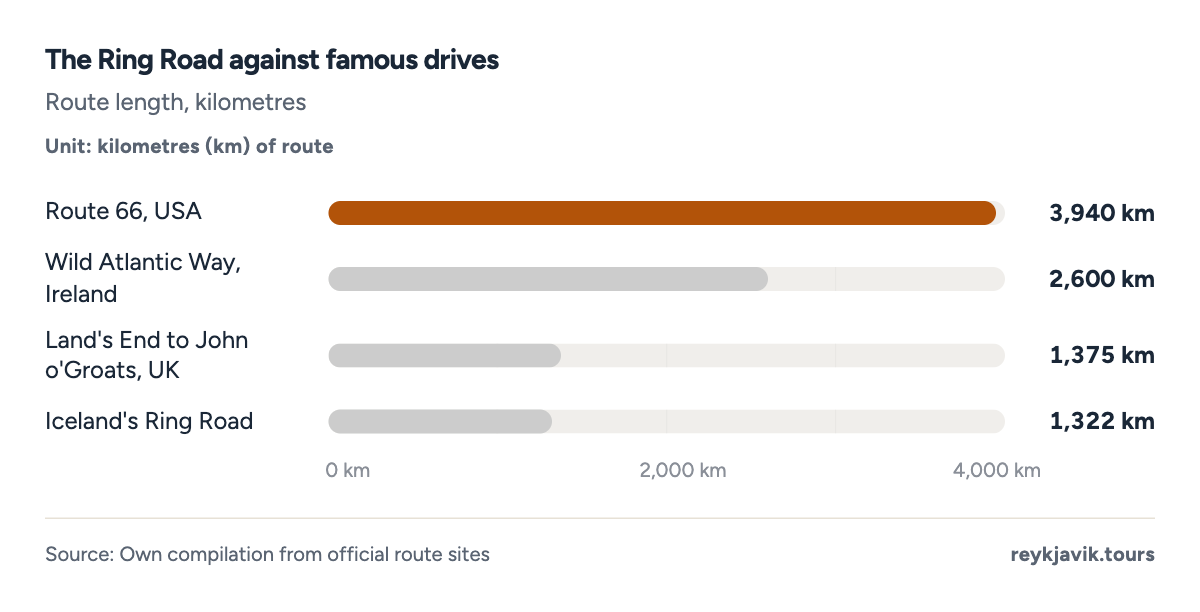
- Route 66 is three times the Ring Road's length - and half of it is not coastal.
- Ireland's Wild Atlantic Way runs about twice as far, on narrower roads.
- The Ring Road is the shortest of the famous drives - and the only all-island one.
How many hours to drive the Ring Road in Iceland?
Nonstop, the Ring Road takes about 16 to 20 hours4 of driving at a realistic 70 km/h average - faster than it sounds, because most of the road is a paved two-laner with a 90 km/h limit5. Nobody should plan it that way. The driving is the sightseeing: waterfalls sit beside the tarmac, sheep own the shoulders, and a Jökulsárlón photo stop is not a delay, it is the point.
Split into the eleven classic legs, no single stretch needs more than 4.4 hours4 behind the wheel - the Akureyri-to-Borgarnes run across the north. The east coast, by contrast, comes in short hops: Höfn to Djúpivogur and Djúpivogur to Egilsstaðir are each about two hours, with fjord views the entire way6.
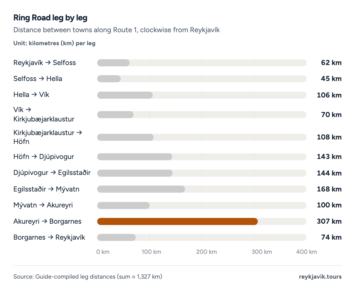
- The longest single stretch - Akureyri to Borgarnes - runs 307 km.
- The east coast breaks into short 140-km hops between fjord towns.
- The full loop of eleven legs sums to about 1,327 km.
| Reykjavík → Selfoss | 62 | 39 | 0.9 |
| Selfoss → Hella | 45 | 28 | 0.6 |
| Hella → Vík | 106 | 66 | 1.5 |
| Vík → Kirkjubæjarklaustur | 70 | 43 | 1.0 |
| Kirkjubæjarklaustur → Höfn | 108 | 67 | 1.5 |
| Höfn → Djúpivogur | 143 | 89 | 2.0 |
| Djúpivogur → Egilsstaðir | 144 | 89 | 2.1 |
| Egilsstaðir → Mývatn | 168 | 104 | 2.4 |
| Mývatn → Akureyri | 100 | 62 | 1.4 |
| Akureyri → Borgarnes | 307 | 191 | 4.4 |
| Borgarnes → Reykjavík | 74 | 46 | 1.1 |
The road itself: surface, tunnels and single-lane bridges
The Ring Road's official name, Þjóðvegur, simply means "the national road" - and for most of Iceland's history that is all it was: a patchwork of mountain tracks and ferry gaps that farmers maintained between hay seasons. Paving reached the last eastern gravel in the 1990s, and the completion of the Vaðlaheiði tunnel in 2018 made today's drive the smoothest in the route's history1. What remains of the old road is part of the charm - the pull-offs, the single-lane bridges with their pull-in bays, and the stretches where the tarmac narrows to let a river pass under a 1970s truss.
The Ring Road is fully paved1 - the gravel-Ring-Road stories date from the 1980s and 1990s, when the last eastern sections were sealed. What the road still has is character: a handful of single-lane bridges survive in the East, where the rule is that the first car to reach the bridge has right of way - and the rental insurance terms mention those bridges by name1. Two tunnels shortcut the old coastal drives: the 7.5 km3 Vaðlaheiði tunnel east of Akureyri (toll, and the fastest route to Mývatn) and the 5.7 km7 Hvalfjörður tunnel north of Reykjavík, toll-free since 20187.
Speed limits are simple: 90 km/h5 on the paved Ring Road, 80 on gravel side roads, and cameras where it matters5. Winter driving is a different sport - wind damage, drifting snow and short daylight mean checking road.is every morning from November to March.
The single-lane bridges deserve their own warning. They survive in the east as engineering heritage: narrow steel trusses the width of one car, some still with the pull-in bays cut into the deck. Two meet head-on and one reverses; Icelandic rental contracts quietly assume you know this. Winter adds its own etiquette - the road.is website and the 1777 phone line become morning rituals, closures are announced by region, and the wind warning for car doors is not a joke: the katabatic gusts off Vatnajökull have bent doors back to their hinges[^vn]7. Locals park bow-first into the wind for a reason. The Ring Road in winter is drivable and dramatic, but it is driven, not cruised. The tunnels have no such romance - Vaðlaheiði charges a toll payable online within hours, Hvalfjörður is free, and both save enough kilometres to justify the fees for anyone driving the whole loop[^vn]7.
| Length | about 1,322 km (822 mi) |
| Completed as a continuous route | 1974 |
| Surface | fully paved |
| Longest tunnel on the route | Vaðlaheiði, 7.5 km (toll) |
| Older tunnel | Hvalfjörður, 5.7 km (free since 2018) |
| Single-lane bridges | a handful remain in the East |
The Golden Circle: the Ring Road's little sibling
Iceland's most driven route is not the Ring Road but the Golden Circle. The Golden Circle Iceland total driving distance is about 230 km8 - a loop from Reykjavík linking Þingvellir, Geysir and Gullfoss8. How many hours to drive Golden Circle Iceland, without stopping? Three to four; with stops it fills a comfortable day. That total driving distance of about 230 km is less than a fifth of the Ring Road's length, which is precisely why it sells: three world-class sights in an afternoon, no overnight planning8.
The stop-by-stop arithmetic: Reykjavík to Þingvellir is 47 km, the rift-park where the North American and Eurasian plates visibly pull apart; Þingvellir to Geysir adds 60 km of upland moor; Geysir to Gullfoss is a mere 10 km past the geothermal power station; and the return via Kerið crater adds a final 113 km of lava fields and greenhouse towns8. Rent an audio guide or a human one - the stones speak Icelandic by default.
For travellers counting kilometres, the Golden Circle adds less than 20% to a south-coast Ring Road day while carrying a disproportionate share of the country's famous sights - the parliament plain, the exploding geysers, and the two-tier waterfall that books use as Iceland's cover image8. The circuit's 230 km divide naturally into a morning leg to Þingvellir, a lunchtime geothermal stop and an afternoon waterfall finale - which is why tour buses, self-drivers and cyclists all complete it comfortably inside daylight hours for nine months of the year8.
And the Ring Road is not the only ring: Fjallabak's highland tracks, the Arctic Coast Way through the northern villages, and the Westfjords' route 60-61 arc add thousands more kilometres for second-visitors - the ring is the trunk, and Iceland keeps growing branches off it. None of those appear in the 1,322 km figure, which is one more reason published lengths disagree: everyone counts a slightly different ring1.
| Reykjavík → Þingvellir | 47 |
| Þingvellir → Geysir | 60 |
| Geysir → Gullfoss | 10 |
| Gullfoss → Kerið | 61 |
| Kerið → Reykjavík | 52 |
Ring Road vs the world's famous drives
Put the Ring Road next to the drives people daydream about and the comparison flatters it. Route 66 in the United States runs 3,940 km2 between Chicago and Santa Monica - three times the Ring Road - but its romance is nostalgia for roadside diners, not raw landscape. Ireland's Wild Atlantic Way stretches 2,600 km2 of coastal counties, and Britain's Land's End to John o'Groats spans 1,375 km2 end to end2. Iceland's loop is the shortest of the three famous drives - and the only one that is genuinely a loop, on an island, where the ocean is never more than an hour away and often in both mirrors.
The practical difference is density. Route 66 spreads its icons across eight states; the Ring Road hands you a national park, a glacier lagoon, a black-sand beach and an erupting (or recently erupting) volcano within a single tank of fuel. That density is why the same week in Iceland delivers more variety than two weeks almost anywhere else2.
Itineraries: how many days the Ring Road needs
Divide 1,322 km by your days and the pace decides the trip. The five-day version is a whistle-stop loop at 265 km4 a day; the classic seven-day itinerary spreads 189 km4 per day, one highlight cluster at a time; ten days drops to 133 km4 and suddenly hikes, lagoons and boat trips fit between drives4. Add a fuel stop every second day and the itinerary becomes a rhythm: drive a leg, see the thing the leg is famous for, sleep, repeat.
Every extra day buys proportionally more than the last, because Iceland's sights sit at deliberate intervals along the road: a waterfall every hour, a glacier tongue every afternoon. A week is the sweet spot most guides settle on - long enough for weather delays, short enough that annual leave survives6.
The classic seven-day clockwise split runs: Reykjavik to Vik via the south coast waterfalls (187 km with stops); Vik to Hofn across the Skaftafell glacier country (273 km); Hofn to Egilsstadir through the east fjords (417 km split over two short days); Egilsstadir to Myvatn's geothermal lake country (168 km); Myvatn to Akureyri (100 km); and the final run from Akureyri back to the capital across the west (381 km with the Hvalfjordur tunnel)6. Anti-clockwise works identically - roughly a third of Ring Road drivers go each way, and the east fjords are the only section where direction changes the view out the window.
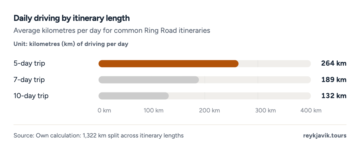
- A 5-day pace means 265 km a day - doable but whistle-stop.
- Seven days drops the load to a comfortable 189 km per day.
- Ten days at 133 km daily leaves time for hikes, lagoons and detours.
| Whistle-stop loop | 5 | 265 | no detour days |
| Classic trip | 7 | 189 | one stop per highlight |
| Relaxed loop | 10 | 133 | time for hikes and lagoons |
What a Ring Road trip really costs in time
Distance and hours are only half the planning equation; the other half is what the road passes. The south coast between Selfoss and Höfn carries the highest density of named sights in the country - Seljalandsfoss, Skógafoss, Reynisfjara, Skaftafell, Jökulsárlón - and most travellers underestimate it by half a day per hundred kilometres. The north spreads its wonders between Akureyri and Mývatn, an hour apart; the east asks only that you drive slowly around each fjord. Planning rule of thumb from guidebooks: budget driving time at 70 km/h, then add 50% for stops on a sightseeing day, and double the segment in winter5.
Fuel is the other constant: at Ring Road consumption of about 7 litres per 100 km, the full loop burns roughly 90-95 litres - two fill-ups and change in a regular car. Petrol stations thin out east of Höfn and between Egilsstaðir and Mývatn, which locals treat as common sense and first-timers learn the hard way6.
Conclusions
- The Ring Road is about 1,322 km (822 miles), fully paved, and loops the entire country - the published range of 1,322-1,339 km depends on which tunnel-era branches you count1.
- Nonstop driving takes 16-20 hours, but no leg exceeds 4.4 hours: the road is built for day-sized chapters, not marathons4.
- The south and north halves feel like different countries - glacier plains and fjords - and the regional split of the road is nearly even at 305-586 km per region4.
- A 7-day itinerary at 189 km a day is the consensus sweet spot; five days is a sprint, ten is a holiday4.
- Against Route 66 or the Wild Atlantic Way the Ring Road is the shortest famous drive on the list - and the only one where the loop itself, not a destination, is the product2.
- Fuel and weather planning complete the budget: roughly 90-95 litres of petrol for the loop and a daily road.is check from November to March6.
Methodology
- Route length and history: current Vegagerðin and Wikipedia figures
- Leg distances: standard guide compilations, clockwise from Reykjavík
- Itineraries: own calculation over the published length
- Golden Circle: standard circuit via Þingvellir, Geysir, Gullfoss, Kerið
Definition. The Ring Road means Route 1 (Þjóðvegur 1), the signed national ring highway. Leg distances are the driving distances between the classic overnight towns, compiled from travel guides, and are accurate to a few kilometres depending on the exact routing chosen through each town.
Data sources. Wikipedia's Route 1 article and Vegagerðin (Icelandic Road and Coastal Administration) for length, completion year and surface; Visit North Iceland for the Vaðlaheiði tunnel; Guide to Iceland for toll history, leg distances and Golden Circle figures (commercial, labelled); speed limits from Icelandic transport guidance.
Calculations. Miles are kilometres × 0.621371. Driving hours divide each leg by a 70 km/h average - a planning figure for open-road cruising, not a speed-limit change. Itinerary paces divide 1,322 km by the itinerary length. The regional split assigns each leg to the region it crosses.
Limitations. Published Ring Road lengths differ by a few kilometres between sources because tunnels and town bypasses change the alignment. Leg distances are guide compilations accurate to a few kilometres. Driving hours assume dry conditions in season; winter travel is slower and weather-dependent.
Sources
- Wikipedia / Vegagerðin. “Route 1 (Þjóðvegur 1), Iceland's Ring Road - length and history.” Wikipedia; Icelandic Road and Coastal Administration (Vegagerðin), 2026. en.wikipedia.org. Accessed 2026-09-17. Back to text
- Own compilation from official route sites. “Comparison routes: Route 66, Wild Atlantic Way, Land's End-John o'Groats.” own compilation, 2026. reykjavik.tours. Accessed 2026-09-17. Back to text
- Visit North Iceland. “Vaðlaheiði Tunnel - 7.5 km toll tunnel on the Ring Road.” regional tourism portal, 2026. visitnorthiceland.is. Accessed 2026-09-17. Back to text
- Reykjavik Tours. “Own calculations: conversions, hours and itinerary pacing (labelled).” own calculation, 2026. reykjavik.tours. Accessed 2026-09-17. Back to text
- Icelandic transport guides. “Speed limits in Iceland: 90 paved / 80 gravel.” commercial, labelled, 2026. island.is. Accessed 2026-09-17. Back to text
- Guide to Iceland and Iceland travel guides (commercial, labelled). “Ring Road leg distances between towns.” travel guides, 2026. guidetoiceland.is. Accessed 2026-09-17. Back to text
- Guide to Iceland. “Road tolls in Iceland - Hvalfjörður Tunnel free since 2018.” commercial, labelled, 2026. guidetoiceland.is. Accessed 2026-09-17. Back to text
- Iceland travel guides. “Golden Circle route distances and driving times.” commercial, labelled, 2026. guidetoiceland.is. Accessed 2026-09-17. Back to text
About the author
Laufey turns public statistics on tourism and travel into research people can check and cite.
Every figure on this page links to its source. How we research
Related research
More data on Iceland's weather and travel from Reykjavik Tours.
- Travel planningHow Often Can You See the Northern Lights in Iceland? (2026 Data)~50% chance of aurora on any dark-season nightRead the research →
- TravelHow Many Days in Iceland? (2026 Data)7.1 nights average stay of foreign visitorsRead the research →
- PricesHow Much Is Gas in Iceland? (2026 Data)259 ISK average petrol price in Iceland, per litreRead the research →
- HousingAverage Rent in Iceland (2026 Data)ISK 269k average monthly rent in IcelandRead the research →
- HousingHow Much Is a House in Iceland? (2026 Data)$467k-779k typical capital-region apartmentRead the research →
- TransportHow Many Airports in Iceland? (2026 Data)33 airports in IcelandRead the research →