Biggest Glacier in Iceland (2026 Data)
Vatnajökull and all 269 Icelandic glaciers, sized: areas, retreat since the 1890s, coverage percentage, ice caves, national parks and the biggest of everything else.
- Published
- Updated
- 6 sources
- 31 statistics
- 9 min read

- M.Sc. in Atmospheric Sciences, University of Iceland (Háskóli Íslands), with a minor thesis on North Atlantic storm-track variability
- Former research assistant at the Icelandic Meteorological Office (Veðurstofa Íslands), working on subarctic climate modeling and volcanic-ash dispersion forecasting
- B.A. in Sociology, also from the University of Iceland, with fieldwork on rural depopulation and tourism's impact on small fishing communities (Westfjords focus)
- Grew up in Akureyri, spent seven years living in Reykjavík and two in a small village in the Westfjords - brings first-hand experience of Iceland's regional weather extremes and community life
- Fluent in Icelandic and English; has translated Icelandic Met Office public advisories for international outlets
- Published field notes and data-driven pieces on glacier retreat (Vatnajökull), aurora forecasting, and the socioeconomic effects of overtourism in the Golden Circle

- M.A. in Journalism, University of Iceland, with additional coursework in Environmental Communication at the University of Bergen (Norway), giving a comparative Nordic lens
- 12+ years in Icelandic media, including editorial roles at RÚV (Iceland's national broadcaster) covering weather-related public safety reporting (storms, volcanic eruptions, road closures)
- Former fact-checking lead for a travel-and-culture desk, specializing in verifying tourism statistics, safety advisories, and climate data against primary sources (Vedur.is, Statistics Iceland)
- Has overseen editorial standards for bilingual (Icelandic/English) publications, ensuring both cultural nuance and accuracy for international readers
- Advocate for citing primary sources (Icelandic Met Office, Icelandic Tourist Board / Ferðamálastofa) rather than secondhand reporting
Key findings
- 7,720 km²The biggest glacier in Iceland is Vatnajökull: 7,720 km² in 2019, Europe's largest ice cap.
- 269Iceland counted 269 glaciers in its national inventory around the year 2000.
- 10.1%Glaciers covered 10.1% of Iceland in 2019 - about 10,400 km² of the country.
- 2,200 km²Iceland's glaciers have lost about 2,200 km² of area since the 1890s.
- 99%Okjökull lost 99% of its area, lost its glacier status in 2014, and got a funeral.
- 3Iceland has 3 national parks; Vatnajökull National Park is a UNESCO World Heritage Site.
The biggest glacier in Iceland is Vatnajökull - 7,720 km2 of ice at the last full survey in 20197,720 km21, making it the largest ice cap in Europe by volume. It is not a lone giant but the head of a family: 269 glaciers2 were counted in the national inventory, from Vatnajökull's continental-scale dome down to Okjökull, which melted so completely that Iceland held a funeral for it in 20191.
Iceland's ice is shrinking on every scale this page can measure. The glaciers covered about 10,400 km21 in 2019 - 10.1% of the country - down 2,200 km21 from the end of the 19th century. Below: every big glacier sized and compared, the retreat quantified glacier by glacier, and the answers to the whole superlatives cluster this search family asks - biggest lake, church, stadium, crater and the rest.
How many glaciers in Iceland?
Iceland has 269 glaciers2, per the national inventory compiled around the year 2000. The number is a moving target: small glaciers keep slipping below the ice that defines them. Beyond the famous fourteen, the Tröllaskagi peninsula in northern Iceland alone carries more than 1703 small cirque glaciers and glacier remnants3.
The inventory counts anything that still moves as ice: ice caps, outlet glaciers, valley and cirque glaciers, and remnants. Okjökull in the west lost that status - after shrinking 99% from its maximum, what remained by 2019 was 0.07 km21 of stagnant ice, and scientists declared it dead in 20141. Its bronze memorial plaque, "A letter to the future", was the first funeral for a glacier anywhere in the world.
- Ice-free land92,725 km²89.9%
- Glacier ice10,400 km²10.1%
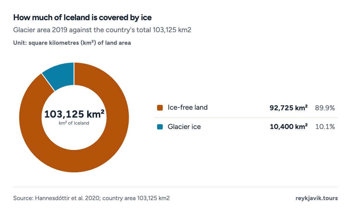
- Glaciers cover 10.1% of Iceland - down from 11% in 2008.
- Iceland without its glaciers would still be the same country - 92,725 km2 of it.
What is the biggest glacier in Iceland?
Vatnajökull - literally "water glacier" - is Vatnajokull at 7,720 km21 (2019), covering about 7.5%1 of the entire country by itself. By volume it is Europe's largest ice cap: roughly 3,000 km33 of ice, up to 950 m thick, burying seven active volcanic systems including Grímsvötn, Iceland's most frequent erupter3.
The scale is hard to hold in the head. Vatnajökull is bigger than the entire country of Puerto Rico. Its largest outlet glacier, Brúarjökull, alone covers 1,600 km21 - more than the second-place Langjökull and third-place Hofsjökull combined. All of Iceland's other 268 glaciers could fit inside Vatnajökull with room to spare.
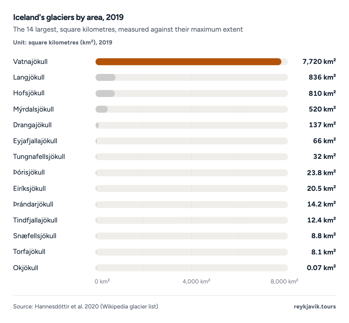
- Vatnajökull is by far the biggest glacier in Iceland at 7,720 km2 in 2019.
- Only four glaciers exceed 500 km2; ten of the fourteen measure under 100 km2.
- Every single glacier in the table is smaller today than at its measured maximum.
| Vatnajökull | 8,326 | 8,086 | 7,720 | 12 |
| Langjökull | 992 | 904 | 836 | 24 |
| Hofsjökull | 948 | 889 | 810 | 22 |
| Mýrdalsjökull | 652 | 597 | 520 | 29 |
| Drangajökull | 161 | 146 | 137 | 49 |
| Eyjafjallajökull | 87 | 80 | 66 | 43 |
| Tungnafellsjökull | 40 | 38 | 32 | 34 |
| Þórisjökull | 30 | 30 | 23.8 | 46 |
| Eiríksjökull | 25.4 | 22 | 20.5 | 45 |
| Þrándarjökull | 27 | 17 | 14.2 | 59 |
| Tindfjallajökull | 16.8 | 15 | 12.4 | 45 |
| Torfajökull | 16 | 11 | 8.1 | 64 |
| Snæfellsjökull | 13.9 | 12 | 8.8 | 65 |
| Okjökull | 7.4 | 4 | 0.07 | 99 |
Iceland glacier coverage percentage: one tenth of the country
For readers asking how much of Iceland is covered by ice: glaciers covered 10.1%1 of the country in 2019 - about 10,400 km21 of the country's 103,125 km2. A generation ago the share was 11%3 (2008), and in the 1890s the ice began from a base 2,200 km21 larger than today's total.
The donut chart above puts the ratio in one glance: for every square kilometre of ice there are nine of fire, sand and green moss. But the ratio is drifting - the coverage percentage is falling by roughly a full percentage point per generation, and the trend line in the next section shows the projection crossing below 10,000 km21 within the coming decade1.
- Vatnajökull7,720 km²74.2%
- Langjökull836 km²8%
- Hofsjökull810 km²7.8%
- Mýrdalsjökull520 km²5%
- Other 265 glaciers514 km²4.9%
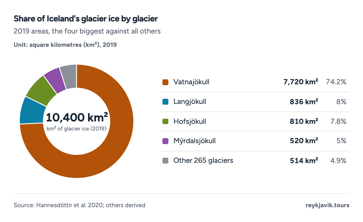
- Vatnajökull alone holds about three quarters of all glacier ice in Iceland.
- The four big ice caps together cover 95% of the national glacier area.
| 1890s (derived) | 12,600 |
| c. 2000 (inventory) | 11,079 |
| 2019 | 10,400 |
The retreat, glacier by glacier
No glacier in the measured set gained area. The published losses from each glacier's maximum run from 12%1 (Vatnajökull) to 99%1 (Okjökull), and the smaller the glacier, the faster the relative decline: Torfajökull and Snæfellsjökull have lost nearly two-thirds of their maximum area, while Þrándarjökull in the east is down 59%11.
Big numbers hide in percentages. Vatnajökull's modest-sounding 12% loss equals 606 km21 - an area larger than Malta. Hofsjökull's 22% equals 138 km21, about twice the size of Manhattan. This is the arithmetic of the climate crisis in miniature: the giants lose slowly in relative terms and enormously in absolute ones, while the small glaciers are simply going1. Glaciologists expect the smallest cirque glaciers of the north to disappear entirely within decades, which will push the 269-glacier count steadily downward even as the big caps remain too large to vanish on any human timescale3.
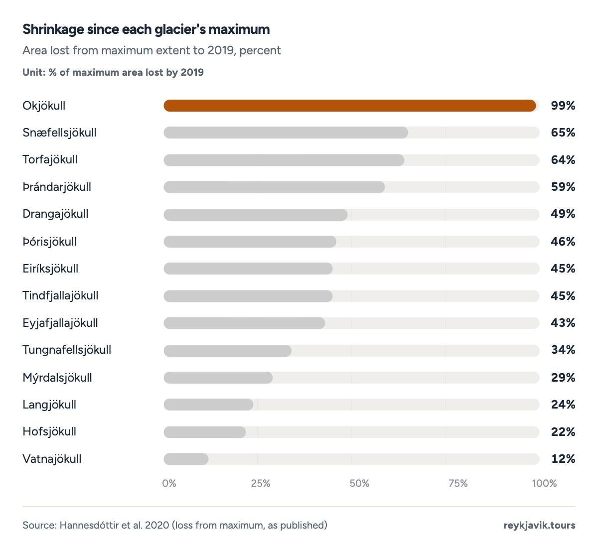
- Okjökull has lost 99% of its area and is no longer counted as a glacier.
- Vatnajökull's 12% loss looks small - but equals 606 km2, an area bigger than Malta.
- Every glacier in the measured set is in decline; none gained area.
Ice caves and the national parks
How many national parks are there in Iceland? Three - and the newest wraps the biggest glacier. How many ice caves are in Iceland? No official count exists - the glaciers form and destroy caves every season. Operators run tours into dozens of them, and two are visitable year-round: the Katla Ice Cave under Mýrdalsjökull's Kötlujökull outlet - described by operators as the largest accessible naturally formed ice cave in the country - and the Crystal Cave in Vatnajökull4. The rest are winter-only, because summer melt reopens the plumbing.
Asked how much ice in Iceland there actually is, the answer has two dimensions: the 10,400 km23 of area covered above, and the volume - roughly 3,000 cubic kilometres3 of ice, enough that if it all melted, global sea level would rise about a centimetre on its own. Volume is the more fragile of the two numbers: thinning hits the whole surface at once, so the ice is losing depth even where its outline barely changes from year to year3.
Vatnajökull is also the core of its namesake national park, established 20085 and inscribed by UNESCO in 20195 - one of the largest national parks in Europe, wrapping the ice cap plus Skaftafell and Jökulsárgljúfur. Iceland's three national parks (Þingvellir 1930, Snæfellsjökull 2001, Vatnajökull 2008) together protect much of the country's most visited terrain, and two of the three are UNESCO World Heritage Sites5.
| Þingvellir | 1,930 | UNESCO World Heritage Site 2004 |
| Snæfellsjökull | 2,001 | The only park on the coast; covers the volcano and glacier |
| Vatnajökull | 2,008 | UNESCO World Heritage Site 2019; among Europe's largest parks |
| Katla Ice Cave | Mýrdalsjökull (Kötlujökull outlet) | Year-round tours; described by operators as the largest accessible naturally formed ice cave |
| Crystal Cave | Vatnajökull (Breiðamerkurjökull) | Winter season, blue-ice show cave |
| Dozens of seasonal caves | Vatnajökull, Langjökull, Mýrdalsjökull | Form and vanish with melt each season; no official count |
The biggest of everything: the landmark superlatives
This search family also asks after Iceland's other biggest things, so here they are, measured and sourced: The biggest lake in Iceland is Þórisvatn6 at 88 km26, a reservoir on the Þjórsá - which is itself the biggest river in Iceland at 230 km6. The biggest church in Iceland is Hallgrímskirkja in Reykjavik at 74.5 m6, still the city's tallest structure. The biggest stadium is the national Laugardalsvöllur, seating 15,0006 - a reminder that the whole country has fewer people than many single stadiums hold on a derby day6.
| Biggest lake | Þórisvatn | 88 km2 (a reservoir on the Þjórsá) |
| Longest river | Þjórsá | 230 km |
| Tallest church | Hallgrímskirkja | 74.5 m |
| Biggest stadium | Laugardalsvöllur | 15,000 capacity |
| UNESCO sites | Þingvellir, Surtsey, Vatnajökull NP | 3 sites (2004, 2008, 2019) |
| Biggest glacier | Vatnajökull | 7,720 km2 in 2019 |
Projection: linear trend of 1890–2019 per-decade values, 95% prediction range. Our calculation, not a forecast.
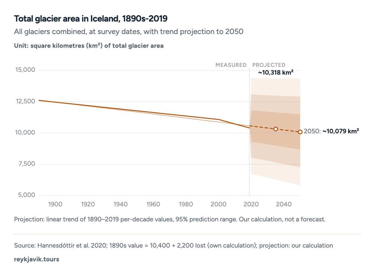
- Iceland's glaciers have lost about 2,200 km2 since the end of the 19th century.
- The 2019 total of 10,400 km2 is down 6% from the ~11,079 km2 measured around 2000.
- The projection crosses 10,000 km2 before 2040 - our calculation, not a forecast.
Fire under the ice
The reason a glacier grows this big here is the same reason it is dangerous: Vatnajökull sits on the volcanic hotspot. Seven volcanic systems lie under the ice, including Grímsvötn - Iceland's most frequently erupting volcano - and Bárðarbunga, whose 2014-15 Holuhraun eruption melted through the glacier margin3. Subglacial eruptions punch through hundreds of metres of ice as steam explosions, and meltwater gathers in Grímsvötn's caldera lake until it bursts out as a jokulhlaup, a glacial flood that can carry icebergs the size of buildings across the Sandur plains at highway speed3.
The ice also remembers the climate. The current maximum extent dates from the Little Ice Age, which squeezed Icelandic farms from the 15th century until about 1900; the glaciers have been retreating, with brief surge-driven pauses, ever since1. Farms abandoned under the advancing ice of the 1700s have been re-exposed, stone by stone, by the retreat of the last century. Reading the glacier is reading the country's agricultural history in reverse. The same ice that once buried the farms now feeds the rivers that power the country: glacial rivers drive a large share of Iceland's hydroelectric turbines, which is why the retreat shows up not just in photographs but in the national energy accounts - a connection few visitors make between the ice they photograph and the electricity their hotel room runs on1. The bitter irony is that the glaciers here are both a power source and a casualty: the water they release is renewable, but the ice producing it is not - once a glacier like Okjokull is gone, no grid contract brings it back.
Seeing the glacier: ice caves, tongue walks and the ring road
Tourism has grown around the ice as fast as the ice has shrunk. Skaftafell, once a national park in its own right, is now the busiest gateway of Vatnajökull National Park, where the Svínafellsjökull tongue lets walkers stand on the ice an hour from the car park. Sólheimajökull on the south coast markets its retreat itself - lagoon photographs from 2010 beside today's shoreline tell the story without a single graph. Ice-cave season runs from November to March for most caves, with the two year-round sites under Katla and in Vatnajökull covering the summer4.
The practical arithmetic for a traveller: a glacier walk runs a few hours, an ice-cave tour half a day, and the Jökulsárlón glacier lagoon - where Breiðamerkurjökull's ice calves into tidal water - is free to watch from the shore at any hour. The lagoon did not exist before about 1935; it is the retreat, made visible, filling with seals and tour boats3.
The superlative sweep: biggest of the rest
Iceland's superlatives extend well beyond glaciers, and this search family asks for all of them. Here is the complete rundown, each answer tied to its measurement:
- The biggest ice cave in Iceland is currently the Katla Ice Cave under Myrdalsjokull's Kotlujoekull outlet - operators describe it as the largest accessible naturally formed ice cave in the country, and unlike most caves it runs tours all year4.
- The biggest stadium in Iceland is the national Laugardalsvöllur in Reykjavik, seating 15,0006 spectators - roughly one seat for every 26 Icelanders6.
- The biggest indoor arena in Iceland is Laugardalshöll in Reykjavik, the country's main concert and indoor-sports hall; Iceland built no dedicated arena of the continental scale, and touring acts play either the hall or the stadium in summer6.
- The biggest football club in Iceland by honours is KR Reykjavik, the oldest club in the country and its most successful across the domestic league's century of play6.
- The biggest building in Iceland is generally counted as the Smaralind shopping centre in Kópavogur or, by enclosed volume, the University of Iceland'sasketta complex - Iceland simply does not build enormous single structures; its tallest point, Hallgrimskirkja at 74.5 m6, is a church6.
- The biggest crater in Iceland is the Askja caldera in the highlands, about 8 km6 across, holding the deep lake Oskjuvatn; the photogenic Kerid crater is far smaller but far easier to reach from Reykjavik6.
- How many black sand beaches in Iceland? There is no official register - the basalt coast produces them continuously - but a handful are famous enough to have names: Reynisfjara near Vik, Solheimasandur with its plane wreck, and Stokksnes below Vestrahorn6.
- For the Iceland number of UNESCO world heritage sites question, the answer is three5: Þingvellir (2004), the island of Surtsey (2008) and Vatnajökull National Park (2019)5.
- The biggest ski resort in Iceland is Hlíðarfjall above Akureyri in the north, with Bláfjöll outside Reykjavik as the capital's own slope - both dwarfed, in vertical metres, by the glaciers themselves, which offer summer skiing on Tonga... on Langjokull's snowfields in good years6.
Conclusions
- Vatnajökull reigns at 7,720 km21 (2019) - and by volume the largest ice cap in Europe, hiding seven active volcanoes under its dome3.
- Iceland has 269 glaciers2, but the ice is concentrated: four ice caps hold 95% of the national glacier area, and Vatnajökull alone holds about three quarters1.
- The retreat is universal and accelerating: every measured glacier is smaller than its maximum, the national total is down 2,200 km21 since the 1890s, and the projection crosses 10,000 km2 before 20401.
- Small glaciers die first - Okjökull lost 99% of its ice and its glacier status, a rehearsal for what the 45-65% losses at Snæfellsjökull, Torfajökull and Þrándarjökull imply within decades1.
- The ice is the tourism: the national park named for Vatnajökull is a UNESCO site, the ice caves under Mýrdalsjökull run year-round tours, and the glacier views sell the ring road - meaning the retreat is an economic story, not only a scientific one5.
- Measure the superlatives while they last: the inventory is a snapshot, Okjökull has already left the list of true glaciers, and the projection has the national total crossing below 10,000 km2 within the coming decade - today's charts are the high side of the icy future1.
Methodology
- Glacier areas: maximum (c. 1945-46), c. 2000 and 2019, for the 14 largest (Hannesdóttir et al. 2020)
- National total: c. 2000 inventory and 2019 (Miodońska 2019 / Hannesdóttir 2020)
- Landmark superlatives: current Wikipedia/registry values
Definition. Glacier areas are planimetric (map) areas. 'Maximum' is each glacier's measured maximum, close to the 1945-46 survey for most. The 1890s national total is derived: 10,400 km2 (2019) plus the published ~2,200 km2 lost since the end of the 19th century.
Data sources. Hannesdóttir et al. 2020 (Jökull) glacier table as compiled on Wikipedia's List of glaciers in Iceland; Miodońska 2019 inventory figures; UNESCO and national-park authorities; Wikipedia for landmark dimensions (Þórisvatn, Þjórsá, Hallgrímskirkja, Laugardalsvöllur); Guide to Iceland and ice-cave operators for cave access (commercial, labelled).
Calculations. The 'Other 265 glaciers' donut slice is 10,400 km2 minus the four named ice caps. The 1890s total is 10,400 + 2,200 = 12,600 km2 (derived, labelled in the table). Vatnajökull's absolute loss is 8,326 - 7,720 = 606 km2. The projection is an ordinary least-squares trend with a 95% prediction interval computed by the renderer; with only three survey dates it is indicative, not predictive.
Limitations. Areas carry measurement uncertainty of a few percent between surveys, and 'maximum' dates differ slightly per glacier. The 269-glacier count is the c. 2000 inventory; the live count is lower as remnants die. Ice-cave numbers are operator-reported (commercial, labelled) - no official registry exists. The landmark measures are current registry values and change rarely.
Sources
- Hannesdóttir et al. 2020 (table via Wikipedia, 'List of glaciers in Iceland'). “A 58-year glaciological record / glacier area changes in Iceland.” Jökull / Icelandic Glaciological Society, 2020. en.wikipedia.org. Accessed 2026-09-17. Back to text
- Guide to Iceland. “Glaciers in Iceland: 269 glaciers in the ~2000 inventory.” commercial, labelled, 2026. guidetoiceland.is. Accessed 2026-09-17. Back to text
- Wikipedia. “Glaciers of Iceland - coverage, totals, Miodońska 2019 inventory.” Wikipedia, 2026. en.wikipedia.org. Accessed 2026-09-17. Back to text
- Guide to Iceland / ice-cave tour operators. “Ice caves in Iceland: Katla and Crystal cave, year-round access.” commercial, labelled, 2026. guidetoiceland.is. Accessed 2026-09-17. Back to text
- UNESCO World Heritage Centre / What's On Iceland. “The 3 UNESCO World Heritage Sites in Iceland.” UNESCO, 2026. whc.unesco.org. Accessed 2026-09-17. Back to text
- Wikipedia. “Þórisvatn (88 km2), Þjórsá, Hallgrímskirkja (74.5 m), Laugardalsvöllur (15,000).” Wikipedia, 2026. en.wikipedia.org. Accessed 2026-09-17. Back to text
About the author
Laufey turns public statistics on tourism and travel into research people can check and cite.
Every figure on this page links to its source. How we research
Related research
More data on Iceland's weather and travel from Reykjavik Tours.
- NatureHow Many Trees Are in Iceland? (2026 Data)2% of Iceland is forestRead the research →
- NatureHow Many Square Miles Is Iceland? (2026 Data)39,769 square miles: Iceland's total areaRead the research →
- NatureHow Many Horses in Iceland? (2026 Data)92,000 Icelandic horses in IcelandRead the research →
- NatureHow Often Does the Geysir in Iceland Erupt? (2026 Data)5-10 min between Strokkur's eruptionsRead the research →
- NatureHow Many Waterfalls in Iceland? (2026 Data)1,624 named waterfalls in IcelandRead the research →
- NatureHow Many Volcanoes Are in Iceland? (2026 Data)33 volcanic systems in IcelandRead the research →