How Many Waterfalls in Iceland? (2026 Data)
Iceland's waterfalls counted from official map data, the tallest and most powerful falls, visitor counts at the most popular ones, and how they are protected.
- Published
- Updated
- 26 sources
- 160 statistics
- 10 min read

- M.Sc. in Atmospheric Sciences, University of Iceland (Háskóli Íslands), with a minor thesis on North Atlantic storm-track variability
- Former research assistant at the Icelandic Meteorological Office (Veðurstofa Íslands), working on subarctic climate modeling and volcanic-ash dispersion forecasting
- B.A. in Sociology, also from the University of Iceland, with fieldwork on rural depopulation and tourism's impact on small fishing communities (Westfjords focus)
- Grew up in Akureyri, spent seven years living in Reykjavík and two in a small village in the Westfjords - brings first-hand experience of Iceland's regional weather extremes and community life
- Fluent in Icelandic and English; has translated Icelandic Met Office public advisories for international outlets
- Published field notes and data-driven pieces on glacier retreat (Vatnajökull), aurora forecasting, and the socioeconomic effects of overtourism in the Golden Circle

- M.A. in Journalism, University of Iceland, with additional coursework in Environmental Communication at the University of Bergen (Norway), giving a comparative Nordic lens
- 12+ years in Icelandic media, including editorial roles at RÚV (Iceland's national broadcaster) covering weather-related public safety reporting (storms, volcanic eruptions, road closures)
- Former fact-checking lead for a travel-and-culture desk, specializing in verifying tourism statistics, safety advisories, and climate data against primary sources (Vedur.is, Statistics Iceland)
- Has overseen editorial standards for bilingual (Icelandic/English) publications, ensuring both cultural nuance and accuracy for international readers
- Advocate for citing primary sources (Icelandic Met Office, Icelandic Tourist Board / Ferðamálastofa) rather than secondhand reporting
Key findings
- 1,624Iceland has 1,624 named waterfalls in the official national waterfall layer.
- 887The National Land Survey's hydrography data marks 887 waterfall points across Iceland.
- 787 feetMorsárfoss, Iceland's tallest known waterfall, drops about 787 feet (240 m).
- 1.07 millionGullfoss counted 1.07 million visitors in 2025, 3.7 times as many as Goðafoss.
- 3,849Gullfoss carries 3,849 cubic feet of water per second on average.
- 2.5 timesDettifoss has about 2.5 times the water power of Gullfoss, by our estimate.
- 74%Dynjandi gets 74% of its yearly visitors in June, July and August.
- 1979Gullfoss has been a protected nature reserve since 1979.
Official map data from the Icelandic Institute of Natural History names 1,6241 waterfalls in Iceland, about 40.82 for every 1,000 square miles of the country. The famous ones draw large crowds, with Gullfoss alone counting 1,065,2803 visitors in 2025.
The answer to "how many" still depends on what counts as a waterfall. A national layer of named falls, a Land Survey dataset of unnamed points and the volunteer map OpenStreetMap all give different totals, and the widely repeated figure of 10,000 waterfalls has no published source. This page compares the counts, ranks the tallest, most powerful and most visited falls, and shows how Iceland protects them.
How many waterfalls Iceland has
The most complete official list is a map layer kept by the Icelandic Institute of Natural History. It holds 1,6241 waterfalls, every one with a name, and was built to show which falls enjoy special protection under Iceland's Nature Conservation Act.4 That law protects waterfalls and their immediate surroundings "so that the view of them is not spoiled", which means the layer is both a count and a legal register.
Most of the points come from the National Land Survey's IS 50V map database: 1,2181 of them, or 75%2. Another 2221 come from ÍslandsAtlas and 961 from the 1992 book Íslenskir fossar by Jón Kr. Gunnarsson, with the rest from hiking yearbooks, fishing maps and local reports.
The layer is drawn at a map scale of 1:50,000, and each point carries a stated position accuracy of 50 metres1, about 164 feet. That scale matters for the count: a small fall on a mountain stream may be missing simply because it was never named on a map, while a long series of cascades can appear as several points or as one.
The National Land Survey publishes a second, simpler dataset for European INSPIRE reporting. It marks 8875 waterfall points, without names, and it is the better guide to how many falls appear on a general map. OpenStreetMap, the open map edited by volunteers, holds 8136 waterfalls, of which 4426 have a name. Only 586 of the mapped waterfalls carry a height, so the open map is useful for locations but thin on measurements.
None of these sources supports the popular claim of 10,000 or more waterfalls, and we found no survey or official body that has published such a count.
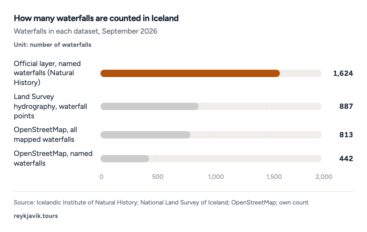
- The official layer names 1,624 waterfalls.
- OpenStreetMap maps 813 waterfalls.
| Sérstök vernd fossar (1:50,000) | Icelandic Institute of Natural History | 1,624 | Named waterfalls under special legal protection |
| INSPIRE hydrography: falls | National Land Survey of Iceland | 887 | Waterfall points on the national map, no names |
| OpenStreetMap | Volunteer mappers | 813 | Mapped waterfalls, named and unnamed |
| OpenStreetMap, named only | Volunteer mappers | 442 | Mapped waterfalls with a name |
- IS 50V map database (National Land Survey)1,21875%
- ÍslandsAtlas22213.7%
- Íslenskir fossar (book, 1992)965.9%
- Other885.4%
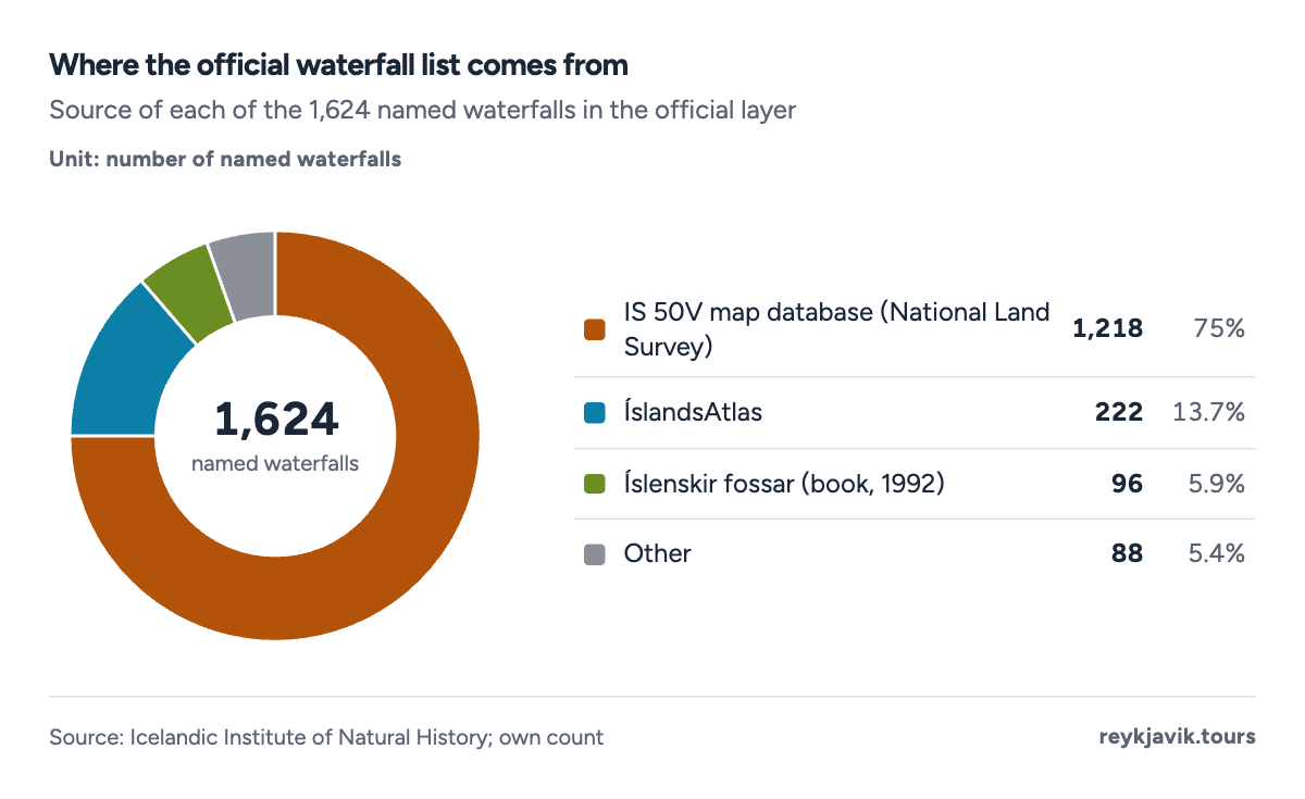
- 75% of the named waterfalls come from the IS 50V database.
- 96 come from a 1992 book on Icelandic waterfalls.
How many named waterfalls in Iceland are there?
The official layer has 1,6241 named waterfalls, but only 7262 different names. 4732 names appear once, while the rest repeat across the country. Most names are built on the word foss, "waterfall", which appears in 89%2 of them.
The most common names are descriptive. Fossar, simply "waterfalls", and Beljandi, "the roaring one", each name 231 falls. Dynjandi, "the thundering one", appears 191 times, as do Stórifoss, "big waterfall", and Selfoss. Famous names repeat too: the layer has 131 waterfalls called Goðafoss, though only one of them is the well-known fall in North Iceland. There are 181 waterfalls called Háifoss, "high waterfall", and 171 called Faxi, "the mane", after the way water spreads over a ledge. Even Gullfoss, "golden waterfall", is not unique: the name appears 71 times in the layer.
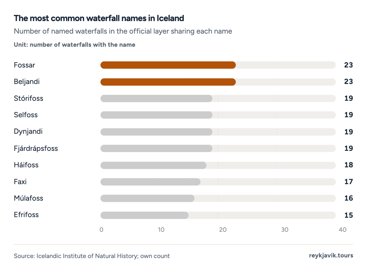
- Fossar and Beljandi each name 23 waterfalls.
- 19 waterfalls are called Dynjandi.
| 1 | Fossar | waterfalls | 23 |
| 2 | Beljandi | the roaring one | 23 |
| 3 | Stórifoss | big waterfall | 19 |
| 4 | Selfoss | shieling waterfall | 19 |
| 5 | Dynjandi | the thundering one | 19 |
| 6 | Fjárdrápsfoss | sheep-drowning waterfall | 19 |
| 7 | Háifoss | high waterfall | 18 |
| 8 | Faxi | the mane | 17 |
| 9 | Múlafoss | ridge waterfall | 16 |
| 10 | Efrifoss | upper waterfall | 15 |
| 11 | Réttarfoss | sheepfold waterfall | 14 |
| 12 | Göngufoss | walking waterfall | 14 |
| 13 | Goðafoss | waterfall of the gods | 13 |
| 14 | Stekkjarfoss | lambfold waterfall | 13 |
Where Iceland's waterfalls are
Placing each official point in its region, the Western Region has the most, 4332 or 26.7%2 of the total, closely followed by the Eastern Region with 4122. The Southern Region, home to the busiest falls, has 2802, and the Westfjords 1922.
The Southern Peninsula region has just 22. The capital area has 452, among them Álafoss and Tungufoss in Mosfellsbær.7 Across the whole country, 1,6241 named falls over Iceland's 39,769 square miles8 means about 40.82 waterfalls per 1,000 square miles.
The two national map datasets agree on the pattern even if not on the numbers: the Land Survey's points also put the East and West first, with 2482 and 2092.
OpenStreetMap shows a different pattern. It has 2282 waterfalls in the Southern Region, the most of any region and close to the official 2802, but only 1342 in the Eastern Region against 4122 official ones.
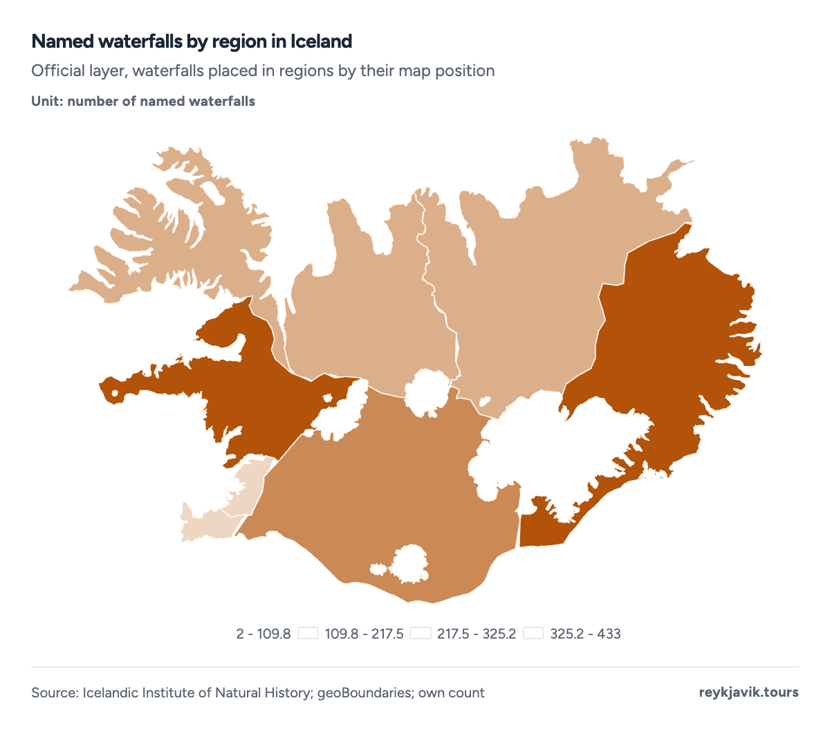
- The Western Region has 433 named waterfalls.
- The Southern Peninsula has 2.
| 1 | Western Region | 433 | 26.7% | 209 | 213 |
| 2 | Eastern Region | 412 | 25.4% | 248 | 134 |
| 3 | Southern Region | 280 | 17.2% | 142 | 228 |
| 4 | Westfjords | 192 | 11.8% | 131 | 111 |
| 5 | Northwestern Region | 136 | 8.4% | 68 | 23 |
| 6 | Northeastern Region | 124 | 7.6% | 64 | 57 |
| 7 | Capital Region | 45 | 2.8% | 25 | 37 |
| 8 | Southern Peninsula | 2 | 0.1% | 0 | 1 |
The biggest waterfall in Iceland depends on the measure
By height, Morsárfoss in Vatnajökull National Park is the tallest known waterfall in the country. It falls from the Morsárjökull glacier down a steep mountain slope in several steps, and measurements show at least one drop of about 787 feet10 (240 m). It lies east of Skaftafell and is not an easily reached roadside fall: seeing it up close takes a long hike.10
Glymur in Hvalfjörður, described by the regional tourism office as the tallest accessible waterfall in the country, drops 650 feet11 (198 m). Hengifoss in East Iceland follows at about 420 feet12 (128 m), then Háifoss at 400 feet13 (122 m) and Dynjandi in the Westfjords at 325 feet7 (99 m).
The best-known falls on the south coast are smaller. Seljalandsfoss drops about 203 feet14 (62 m) and Skógafoss about 197 feet7 (60 m). Even the tallest Icelandic fall is modest on a world scale: Angel Falls in Venezuela drops 3,212 feet15 (979 m), so Morsárfoss is about 25%2 of its height.
Several well-known falls come in groups. Gljúfrabúi, hidden in a gorge next to Seljalandsfoss, drops about 131 feet14 (40 m). On the trail to Hengifoss, Litlanesfoss falls 25 to 30 metres12, about 82 to 98 feet, framed by basalt columns. Below Dettifoss, Hafragilsfoss drops 89 feet16 (27 m), and above it Selfoss drops 33 feet16 (10 m).
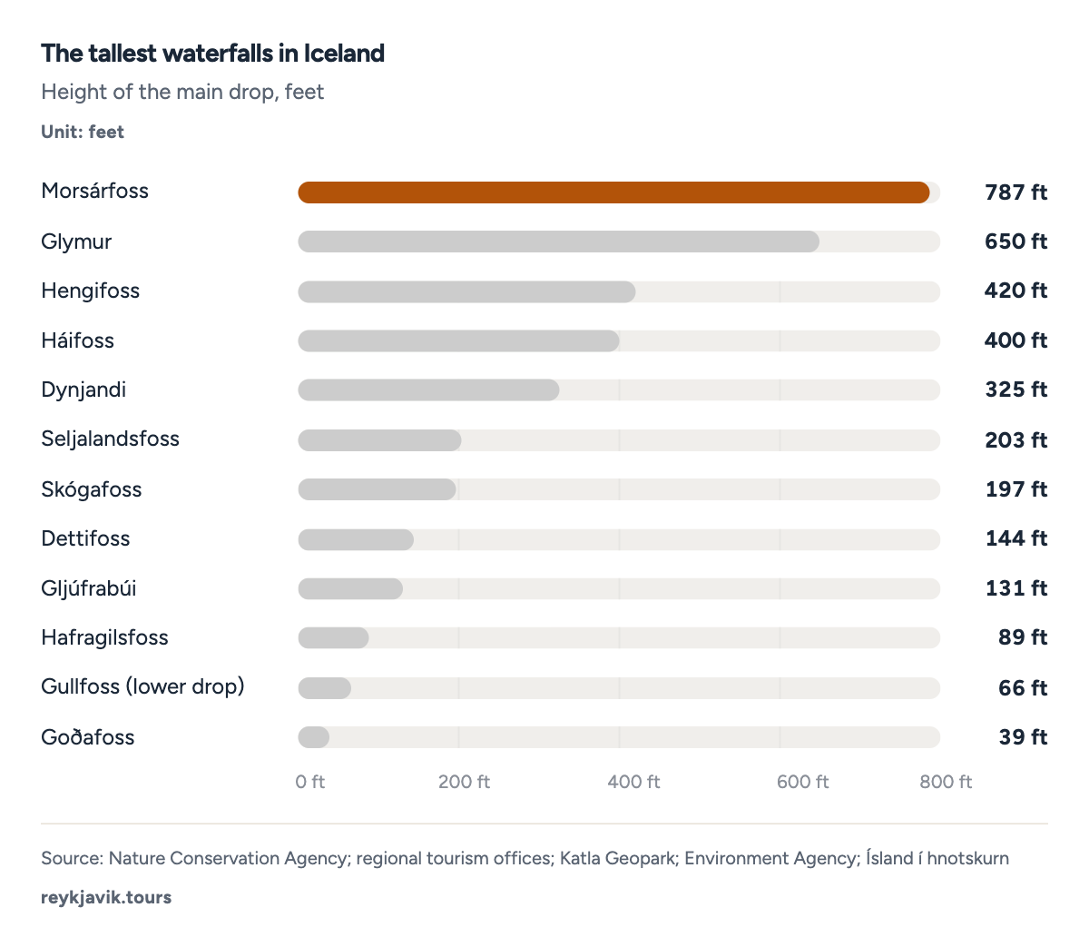
- Morsárfoss drops about 787 ft.
- Goðafoss drops 39 ft.
| 1 | Morsárfoss | 787 | 240 | Southern Region | Ísland í hnotskurn |
| 2 | Glymur | 650 | 198 | Western Region | Visit West Iceland |
| 3 | Hengifoss | 420 | 128 | Eastern Region | Visit East Iceland |
| 4 | Háifoss | 400 | 122 | Southern Region | Visit South Iceland |
| 5 | Dynjandi | 325 | 99 | Westfjords | Nature Conservation Agency |
| 6 | Seljalandsfoss | 203 | 62 | Southern Region | Katla Geopark |
| 7 | Skógafoss | 197 | 60 | Southern Region | Nature Conservation Agency |
| 8 | Dettifoss | 144 | 44 | Northeastern Region | Visit North Iceland |
| 9 | Gljúfrabúi | 131 | 40 | Southern Region | Katla Geopark |
| 10 | Hafragilsfoss | 89 | 27 | Northeastern Region | Vatnajökull National Park |
| 11 | Gullfoss (lower drop) | 66 | 20 | Southern Region | Environment Agency |
| 12 | Goðafoss | 39 | 12 | Northeastern Region | Visit North Iceland |
| 13 | Gullfoss (upper drop) | 36 | 11 | Southern Region | Environment Agency |
| 14 | Selfoss (Jökulsá á Fjöllum) | 33 | 10 | Northeastern Region | Vatnajökull National Park |
| 1 | Morsárfoss | 787 | 240 |
| 2 | Glymur | 650 | 198 |
| 3 | Hengifoss | 420 | 128 |
| 4 | Háifoss | 400 | 122 |
| 5 | Langifoss | 400 | 122 |
| 6 | Hverfandi | 328 | 100 |
| 7 | Rjúkandi | 305 | 93 |
| 8 | Fagrifoss | 262 | 80 |
| 9 | Bjarnarfoss | 259 | 79 |
| 10 | Grundarfoss | 230 | 70 |
| 11 | Drífandi | 230 | 70 |
| 12 | Seljalandsfoss | 200 | 61 |
Biggest waterfall in Europe: Iceland's claim
By force of water, the leader is Dettifoss on the glacial river Jökulsá á Fjöllum. The University of Iceland's science web calls it the most powerful waterfall in Iceland,20 and Vatnajökull National Park describes it as considered the most powerful in Europe.16 It is 144 feet17 high and about 328 feet17 (100 m) wide, and it is slowly eating its way upstream, moving about half a metre16 (1.6 feet) a year.
Power is not the same as volume. The same science web notes that no Icelandic waterfall comes close to the Rhine Falls in Switzerland for the amount of water, and that Iceland's most voluminous fall is Urriðafoss on Þjórsá, with an average flow of 12,819 cubic feet per second20 (363 m³/s). Dettifoss carries about 6,816 cubic feet per second21 (193 m³/s) on average, according to a Perlan museum guide.
Height and flow together decide the power. Multiplying the two, we estimate Dettifoss at about 83 megawatts2 of falling-water power and Gullfoss at about 33 megawatts2, so Dettifoss has roughly 2.5 times2 the power. For comparison, Niagara Falls in peak tourist season carries 100,000 cubic feet per second15, which works out at about 1,584 megawatts2 over the Horseshoe Falls drop, around 19 times2 Dettifoss.
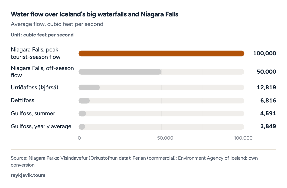
- Urriðafoss carries 12,819 cubic feet per second.
- Gullfoss carries 3,849 cubic feet per second on average.
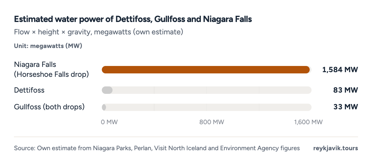
- Dettifoss: about 83 MW.
- Gullfoss: about 33 MW.
| Niagara Falls (Horseshoe Falls drop) | 100,000 | 2,832 | 187 | 1,584 |
| Dettifoss | 6,816 | 193 | 144 | 83 |
| Gullfoss (both drops) | 3,849 | 109 | 102 | 33 |
Width tells a similar story. Dettifoss is Iceland's broad giant at about 328 feet17 across, Goðafoss is 98 feet19 wide and Skógafoss 82 feet7. Niagara's Horseshoe Falls stretches about 2,200 feet15 and drops 188 feet15, taller than Dettifoss as well as wider.
Both are moving. Niagara Parks says Niagara Falls has retreated about 7 miles15 in 12,500 years, an average of close to 3 feet2 a year, while Dettifoss is moving upstream by about half a metre16 a year.
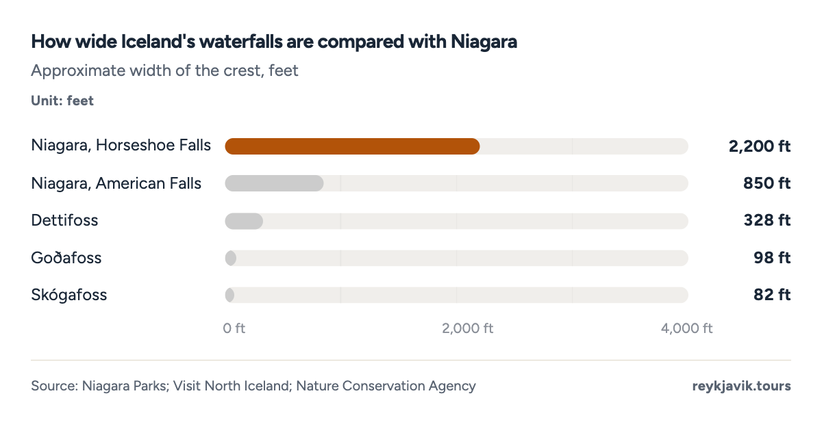
- Dettifoss is about 328 ft wide.
- The Horseshoe Falls is about 2,200 ft wide.
| Angel Falls, Venezuela | 3,212 | - | - |
| Morsárfoss, Iceland | 787 | - | - |
| Glymur, Iceland | 650 | - | - |
| Niagara, Horseshoe Falls | 188 | 2,200 | 100,000 (peak season, whole falls) |
| Dettifoss, Iceland | 144 | 328 | 6,816 |
| Gullfoss, Iceland (two drops) | 102 | - | 3,849 |
| Goðafoss, Iceland | 39 | 98 | - |
The most visited waterfalls in Iceland
The Icelandic Tourist Board and the Environment Agency run automatic counters at popular natural sites, a network that grew from 6 to 24 sites in 2020 and 2021.22 Eight waterfalls have a full year of counts for 2025, and Gullfoss is in a class of its own: its upper-area counter recorded 1,065,2803 visitors, 3.7 times2 as many as Goðafoss with 291,6903.
Dettifoss comes third with 264,8553 on its west bank, followed by Hraunfossar with 148,5543 and Hengifoss with 102,6643. The remote Dynjandi in the Westfjords counted 78,3953, and Glymur, reached only on foot, 47,4083.
Some sites have a second counter on another path, so these figures are a floor, not a total. The west bank of Goðafoss counted another 133,8953 passes in 2025, and the east bank of Dettifoss 58,3593. At Gullfoss, a second counter in the lower area recorded 348,0343 passes, even though it logged no counts from April to June 2025, and the eastern trail at Hengifoss added 20,1993. Adding both banks gives about 425,5852 counted passes at Goðafoss and 323,2142 at Dettifoss, although some visitors walk past both counters. Seljalandsfoss and Skógafoss, two of the best-known south coast falls, have no counter in the dashboard.3
Counts have grown since 2022. Between 2022 and 2025, counts rose by 51%2 at Gullfoss, 43%2 at Dettifoss and 67%2 at Dynjandi.
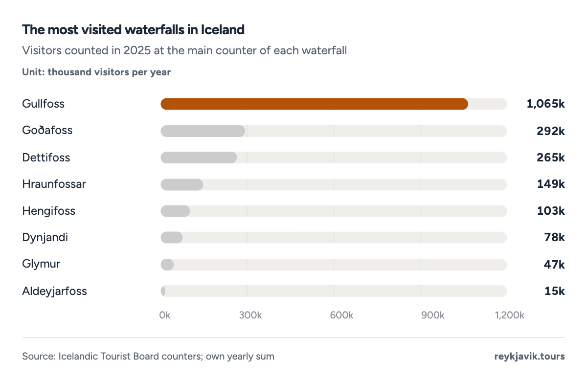
- Gullfoss counted 1,065k visitors in 2025.
- Glymur counted 47k.
- Gullfoss
- Dettifoss
- Dynjandi
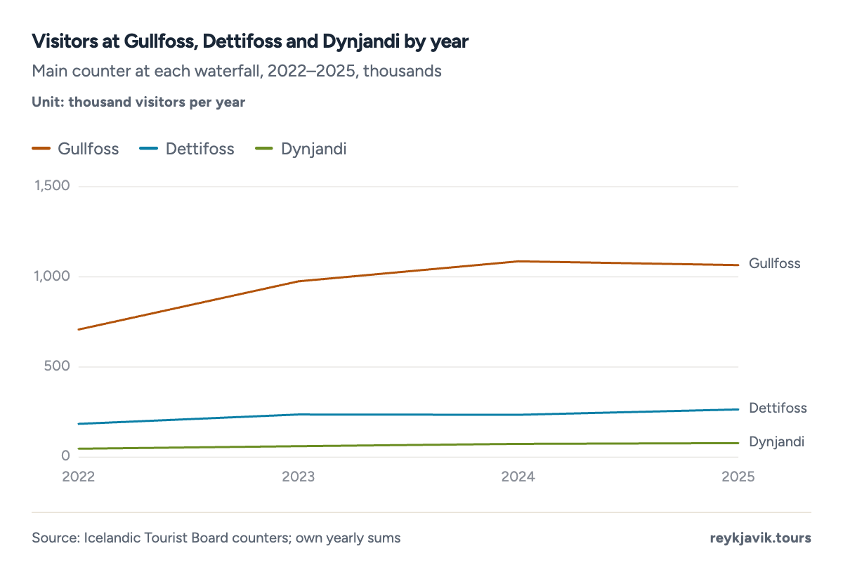
- Gullfoss rose from 708k in 2022 to 1,065k in 2025.
- Dynjandi rose to 78k in 2025.
| 1 | Gullfoss | 707,751 | 975,164 | 1,085,704 | 1,065,280 |
| 2 | Goðafoss | 228,144 | 339,138 | 288,925 | 291,690 |
| 3 | Dettifoss | 184,671 | 237,270 | 235,185 | 264,855 |
| 4 | Hraunfossar | 142,655 | 164,251 | 147,989 | 148,554 |
| 5 | Hengifoss | 90,463 | 114,351 | 84,988 | 102,664 |
| 6 | Dynjandi | 47,027 | 61,269 | 73,626 | 78,395 |
| 7 | Glymur | 34,819 | 41,715 | 40,779 | 47,408 |
| 8 | Aldeyjarfoss | 15,174 | 18,381 | 15,500 | 15,244 |
| 1 | Gullfoss lower area | 348,034 |
| 2 | Goðafoss west bank | 133,895 |
| 3 | Dettifoss east bank | 58,359 |
| 4 | Hengifoss eastern trail | 20,199 |
Is Gullfoss the biggest waterfall in Iceland?
Gullfoss is the most visited, not the tallest or the most powerful. Its two steps drop 1118 and 20 metres18, about 102 feet2 in total, into a gorge about 1.6 miles18 (2.5 km) long and 230 feet18 (70 m) deep. The Environment Agency puts its average flow at 109 cubic metres18 a second, 3,849 cubic feet2, rising to 130 cubic metres18 in summer; the largest flood on record reached 2,000 cubic metres18 a second.
That flood was about 18 times2 the average flow, which shows how much a glacial river can change. Gullfoss is on Hvítá, which flows from the lake Hvítárvatn at the foot of the Langjökull glacier, and the Environment Agency notes that the rock behind the falls includes a loose conglomerate layer that the water washes out easily, which is why the falls keep cutting back into the gorge.18
Visitor numbers follow the seasons, but less sharply than elsewhere. In 2025 the busiest month at Gullfoss was August, with 165,6683 visitors or about 5,344 a day2, and the quietest was December, with 30,3203. Over the year the average was 2,9192 visitors a day.
- 47JanJ
- 62FebF
- 75MarM
- 82AprA
- 92MayM
- 133JunJ
- 164JulJ
- 166AugA
- 108SepS
- 61OctO
- 44NovN
- 30DecD
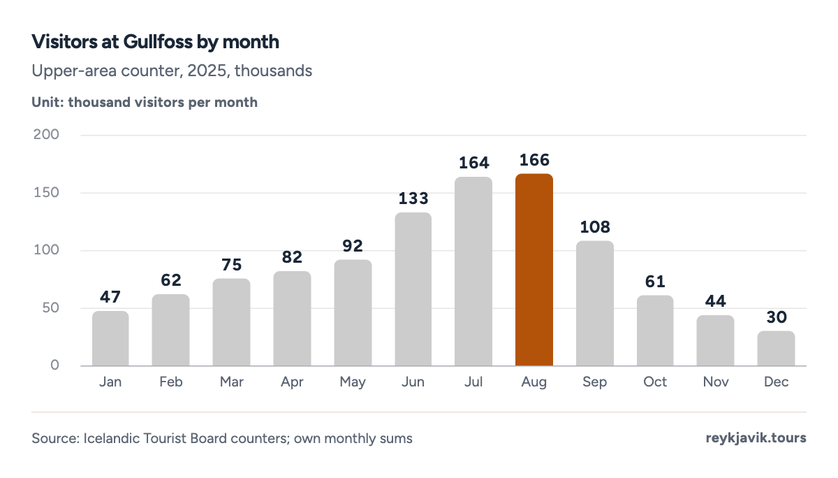
- August was the busiest month, 166k.
- December was the quietest, 30k.
| January | 47,289 | 1,525 |
| February | 62,068 | 2,217 |
| March | 75,003 | 2,419 |
| April | 82,368 | 2,746 |
| May | 91,589 | 2,954 |
| June | 133,381 | 4,446 |
| July | 164,082 | 5,293 |
| August | 165,668 | 5,344 |
| September | 107,768 | 3,592 |
| October | 61,460 | 1,983 |
| November | 44,284 | 1,476 |
| December | 30,320 | 978 |
Remote waterfalls depend far more on summer. Gullfoss got 44%2 of its 2025 visitors in June, July and August. At Dettifoss, where the western access road gets only limited winter service,16 the share was 59%2, and at Dynjandi in the Westfjords 74%2. In January 2025, Dettifoss's west-bank counter recorded only 1663 visitors, against 47,2893 at Gullfoss.
This year's counts show diverging fortunes. From January to August 2026, Gullfoss counted 13.1%2 more visitors than in the same months of 2025, and Glymur 11.0%2 more. Dettifoss counted 19.0%2 fewer, and Hengifoss, adding its two counters together, 35.6%2 fewer. A new counter at Háifoss recorded 34,5843 visitors from February to August 2026.
- Gullfoss
- Dettifoss
- Dynjandi
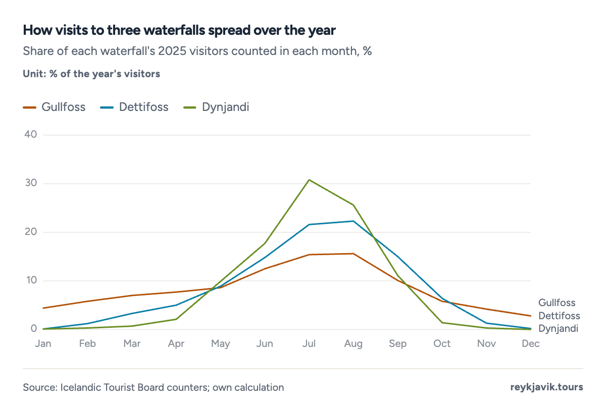
- July brought 30.8% of Dynjandi's visitors.
- July brought 15.4% of Gullfoss's visitors.
| 1 | Gullfoss | 821,448 | 929,174 | +13.1% |
| 2 | Glymur | 38,085 | 42,271 | +11.0% |
| 3 | Dynjandi | 68,340 | 68,276 | −0.1% |
| 4 | Goðafoss | 232,470 | 226,232 | −2.7% |
| 5 | Hraunfossar | 110,047 | 102,218 | −7.1% |
| 6 | Dettifoss | 204,208 | 165,425 | −19.0% |
| 7 | Aldeyjarfoss | 12,373 | 8,927 | −27.9% |
| 8 | Hengifoss (both counters) | 98,071 | 63,178 | −35.6% |
Protected waterfalls in Iceland
Every waterfall enjoys a basic level of protection under article 61 of the Nature Conservation Act, and disturbing one requires a permit and a strong reason.4 A smaller group has been formally protected as a nature reserve or natural monument, managed by the Nature Conservation Agency.7 Gullfoss led the way in 19797, followed by Dynjandi in 19817 and Skógafoss and Hraunfossar in 19877. The Dettifoss series was protected in 19967, Álafoss and Tungufoss near Reykjavík in 201323, and Goðafoss in 20207.
Gullfoss has the most famous protection story. In 190724 an Englishman tried to acquire the waterfall, and in the same year a law limited ownership of Icelandic waterfalls to people and companies based in Iceland, unless special permission was given. A lease on the falls lapsed in 192824; Sigríður Tómasdóttir of the farm Brattholt, who had campaigned to keep the falls unharmed, is remembered with a memorial set up by the falls in 197824. The state bought Gullfoss in 194524, and the reserve created in 1979 covers 164.2 hectares7, about 406 acres2.
The protected areas vary widely in size. The Dynjandi natural monument, which covers the whole series of falls on the river Dynjandisá, is the largest of those with a published size, at 6.4 square kilometres7, about 2.5 square miles, while Álafoss and Tungufoss each cover just 1.4 hectares7, about 3 acres. Goðafoss, protected most recently, covers 0.224 square kilometres7, about 55 acres.
| Gullfoss | Nature reserve | 1979 | 406 acres | Southern Region |
| Dynjandi and the Dynjandisá falls | Natural monument | 1981 | 1,581 acres | Westfjords |
| Skógafoss | Natural monument | 1987 | 455 acres | Southern Region |
| Hraunfossar and Barnafoss | Natural monument | 1987 | - | Western Region |
| Dettifoss, Selfoss and Hafragilsfoss | Natural monument | 1996 | - | Northeastern Region |
| Álafoss | Natural monument | 2013 | 3 acres | Capital Region |
| Tungufoss | Natural monument | 2013 | 3 acres | Capital Region |
| Goðafoss | Natural monument | 2020 | 55 acres | Northeastern Region |
| 1907 | An Englishman seeks to acquire Gullfoss; a law limits waterfall ownership to Iceland residents |
| 1928 | Lease payments for the falls stop and the lease lapses |
| 1939 | Einar Guðmundsson buys the farm Brattholt from Sigríður Tómasdóttir |
| 1945 | The Icelandic state buys Gullfoss |
| 1974 | Einar Guðmundsson gives the land beside the falls to the state |
| 1978 | A memorial to Sigríður Tómasdóttir is set up at the falls |
| 1979 | Gullfoss and its gorge become a nature reserve |
How far the waterfalls are from Reykjavík
Several famous falls are close to the capital. By map routing, Öxarárfoss at Þingvellir is about 32 miles25 away, Glymur 43 miles25, Gullfoss 76 miles25 and Seljalandsfoss 79 miles25, each under about 2.0 hours25 of driving without stops. Skógafoss is 96 miles25 away.
The waterfalls of the north and east need overnight trips. Goðafoss is about 258 miles25 from Reykjavík, Dettifoss 320 miles25, or 7.6 hours25 of driving, and Hengifoss 349 miles25. In between, Svartifoss in Skaftafell is 203 miles25 away, about 4.7 hours25, and Dynjandi in the Westfjords 221 miles25, about 5.2 hours25. Kirkjufellsfoss on the Snæfellsnes peninsula is 110 miles25 from the capital.
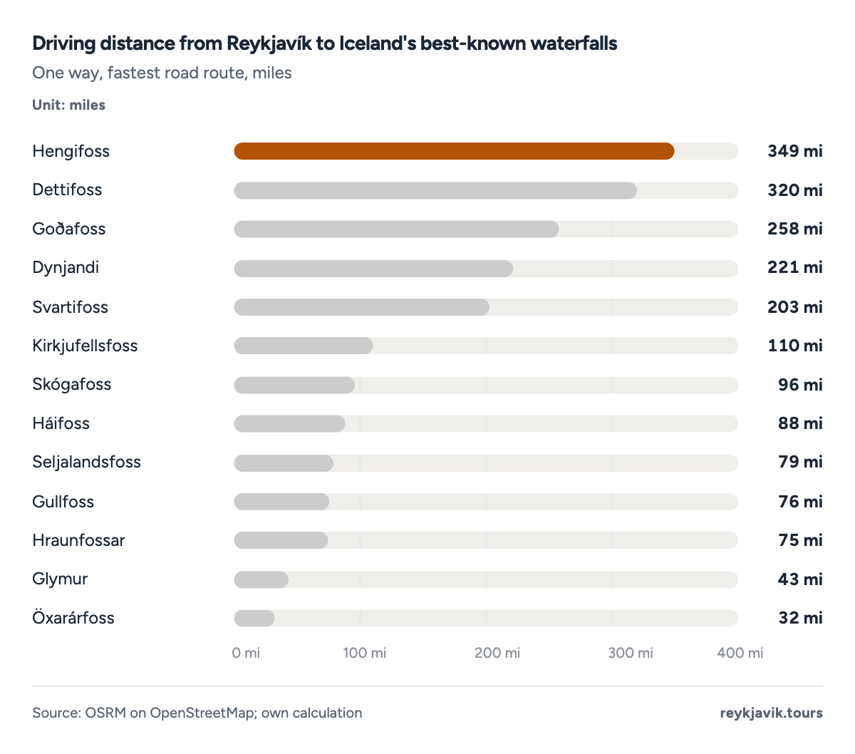
- Hengifoss is 349 mi from Reykjavík.
- Öxarárfoss is 32 mi away.
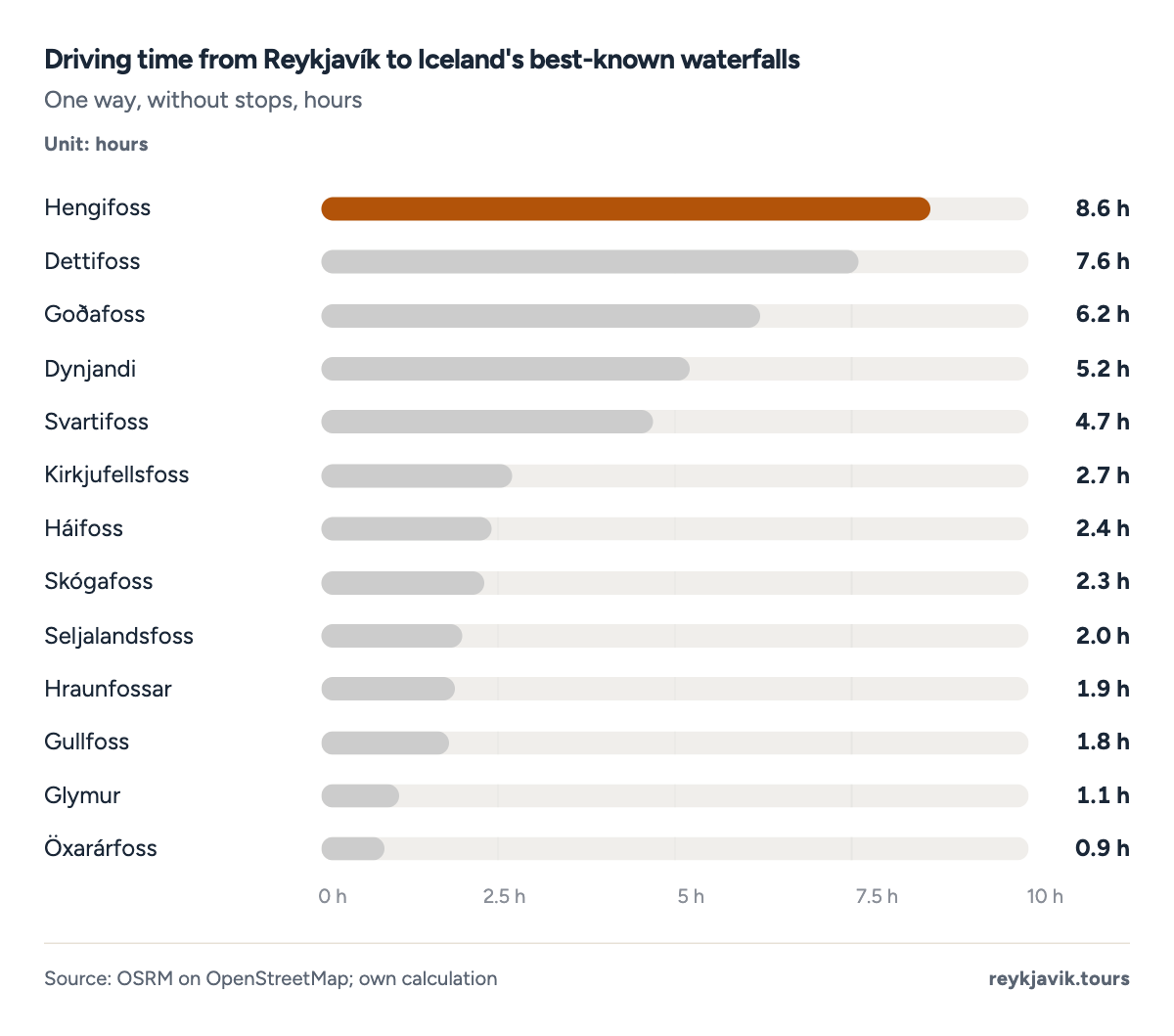
- Dettifoss is 7.6 h from Reykjavík.
- Gullfoss is 1.8 h away.
| 1 | Öxarárfoss | 32 | 51.7 | 0.9 |
| 2 | Glymur | 43 | 70.0 | 1.1 |
| 3 | Hraunfossar | 75 | 120.9 | 1.9 |
| 4 | Gullfoss | 76 | 121.8 | 1.8 |
| 5 | Seljalandsfoss | 79 | 127.2 | 2.0 |
| 6 | Háifoss | 88 | 140.9 | 2.4 |
| 7 | Skógafoss | 96 | 153.9 | 2.3 |
| 8 | Kirkjufellsfoss | 110 | 177.1 | 2.7 |
| 9 | Svartifoss | 203 | 326.0 | 4.7 |
| 10 | Dynjandi | 221 | 355.8 | 5.2 |
| 11 | Goðafoss | 258 | 415.9 | 6.2 |
| 12 | Dettifoss | 320 | 514.3 | 7.6 |
| 13 | Hengifoss | 349 | 561.8 | 8.6 |
What the numbers mean
For a traveller, the useful number is not 1,624 or 10,000 but the handful of falls within reach. The official layer suggests more than 1,6001 named waterfalls are worth a place name, yet the counters show visits concentrated on a few: Gullfoss alone counted more visitors in 2025 than the other seven counted waterfalls combined, 1,065,2803 against 948,8102.
Gullfoss's counter recorded about 5,3442 visitors a day in August 2025, while Glymur, taller than any of the famous south coast falls, drew 47,4083 in the whole year. For comparison, Niagara Falls State Park on the US side alone reported more than 9.5 million26 visitors in 2024, about 8.8 times2 the count at Gullfoss that year.
Only 8 of Iceland's 1,624 named waterfalls have a full year of visitor counts, so what is known about crowds covers a tiny share of the falls. The rest, from the 231 falls called Beljandi to Morsárfoss at the foot of its glacier, are counted only as points on a map.
Conclusions
- Iceland has at least 1,6241 named waterfalls in official data, while no official body publishes a count that includes unnamed falls; the popular "10,000" has no published source.
- The East and West have the most waterfalls, with 8452 of the named falls between them, while the Southern Peninsula region has only 22.
- There is no single biggest waterfall: Morsárfoss is the tallest at about 787 feet10, Dettifoss the most powerful, and Urriðafoss carries the most water, at 12,819 cubic feet per second20.
- Gullfoss is the most visited by a wide margin, with 1,065,2803 visitors counted in 2025, and it was the first of Iceland's formally protected waterfalls, a nature reserve since 19797.
Methodology
- 1,624 named waterfalls
- Visitors 2022–Aug 2026
- 8 counted waterfalls
- Checked Sept 16, 2026
Definition. A waterfall here is a point in the Icelandic Institute of Natural History's layer of waterfalls under special protection, which lists named falls from national map data and other sources. Heights are the main drop in feet with metres; flow is in cubic feet per second with cubic metres per second.
Data sources. Waterfall counts come from the Icelandic Institute of Natural History,1 the National Land Survey's INSPIRE hydrography5 and OpenStreetMap;6 regions from geoBoundaries outlines.9 Heights, widths and flows come from the Nature Conservation Agency, the Environment Agency, Vatnajökull National Park, regional tourism offices, Katla Geopark, Vísindavefur and, for Dettifoss flow, a Perlan guide (commercial). Visitor numbers come from the Icelandic Tourist Board's counter dashboard.3 Driving routes use OSRM on OpenStreetMap.25
Calculations. Counts are features in each dataset on 16 September 2026. Regions are assigned by point-in-polygon; points just offshore go to the nearest region. Density uses Statistics Iceland's area of 103,000 km² (39,769 sq mi). Visitor totals add daily counts per calendar year at the main counter of each waterfall; June–August shares and year-to-date changes use the same counts. Power = 1,000 kg/m³ × 9.81 m/s² × average flow × height, a theoretical upper bound. Feet = metres × 3.28084; cubic feet = cubic metres × 35.3147.
Limitations. No official body publishes a total number of waterfalls, so counts depend on map scale and naming. Heights for Morsárfoss and several falls come from informational or tourism sources, not surveys. Counters record passes on one path and can miss visitors on other paths or during outages; the counter series are too short for a trend projection. Dettifoss flow comes from a commercial source. Driving times assume no stops and summer roads.
Sources
- Icelandic Institute of Natural History (Náttúrufræðistofnun). “Sérstök vernd fossar: waterfalls under special protection, 1:50,000 (WFS layer ni_n50v_serstok_vernd_1_n50v_fossar_p); own count.” Icelandic Institute of Natural History. gis.natt.is. Accessed 16 Sept. 2026. Back to text
- Reykjavik Tours research. “Waterfall counts, shares, flow conversions and power estimates: calculations from the sources listed.” Reykjavik Tours. reykjavik.tours. Accessed 16 Sept. 2026. Back to text
- Icelandic Tourist Board (Ferðamálastofa). “Tourism dashboard: visitors at destinations (automatic counters), 2019–Sept. 2026; own yearly and monthly sums.” Icelandic Tourist Board. maelabordferdathjonustunnar.is. Accessed 16 Sept. 2026. Back to text
- Althingi. “Lög um náttúruvernd nr. 60/2013 (Nature Conservation Act), article 61.” Althingi. althingi.is. Accessed 16 Sept. 2026. Back to text
- National Land Survey of Iceland (Landmælingar Íslands). “INSPIRE hydrography: falls (is_hy_p_lmi_falls), version 2025-01-30; own count.” National Land Survey of Iceland. gis.lmi.is. Accessed 16 Sept. 2026. Back to text
- OpenStreetMap contributors. “Waterfalls in Iceland (waterway=waterfall, natural=waterfall) via the Overpass API; own count (ODbL).” OpenStreetMap Foundation. openstreetmap.org. Accessed 16 Sept. 2026. Back to text
- Nature Conservation Agency of Iceland (Náttúruverndarstofnun). “Friðlýstu svæðin: protected areas (Gullfoss, Dynjandi, Skógafoss, Hraunfossar, Dettifoss, Goðafoss, Tungufoss, Álafoss).” Nature Conservation Agency of Iceland. nattura.is. Accessed 16 Sept. 2026. Back to text
- Statistics Iceland (Hagstofa Íslands). “Several geographical data (UMH01001); source: National Land Survey of Iceland.” Statistics Iceland. px.hagstofa.is. Accessed 16 Sept. 2026. Back to text
- geoBoundaries (William & Mary geoLab). “Iceland ADM1 region boundaries (derived from OpenStreetMap, ODbL).” geoBoundaries. geoboundaries.org. Accessed 16 Sept. 2026. Back to text
- Ísland í hnotskurn. “Morsárfoss.” islandihnotskurn.is (informational). islandihnotskurn.is. Accessed 16 Sept. 2026. Back to text
- Visit West Iceland (Markaðsstofa Vesturlands). “Glymur.” Visit West Iceland (regional tourism office). west.is. Accessed 16 Sept. 2026. Back to text
- Visit East Iceland (Austurbrú). “Hengifoss.” Visit East Iceland (regional tourism office). east.is. Accessed 16 Sept. 2026. Back to text
- Visit South Iceland (Markaðsstofa Suðurlands). “Háifoss waterfall.” Visit South Iceland (regional tourism office). south.is. Accessed 16 Sept. 2026. Back to text
- Katla UNESCO Global Geopark. “Seljalandsfoss and Gljúfrabúi.” Katla UNESCO Global Geopark. katlageopark.com. Accessed 16 Sept. 2026. Back to text
- Niagara Parks Commission. “Niagara Falls Geology: Facts & Figures.” Niagara Parks. niagaraparks.com. Accessed 16 Sept. 2026. Back to text
- Vatnajökull National Park (Nature Conservation Agency). “Dettifoss.” Vatnajökull National Park. vatnajokulsthjodgardur.is. Accessed 16 Sept. 2026. Back to text
- Visit North Iceland (Markaðsstofa Norðurlands). “Dettifoss.” Visit North Iceland (regional tourism office). northiceland.is. Accessed 16 Sept. 2026. Back to text
- Environment Agency of Iceland (Umhverfisstofnun). “Gullfoss: náttúra og jarðfræði (nature and geology).” Environment Agency of Iceland. ust.is. Accessed 16 Sept. 2026. Back to text
- Visit North Iceland (Markaðsstofa Norðurlands). “Goðafoss.” Visit North Iceland (regional tourism office). northiceland.is. Accessed 16 Sept. 2026. Back to text
- Einar Örn Þorvaldsson. “Er Dettifoss vatnsmesti foss Evrópu? (Is Dettifoss Europe's most voluminous waterfall?).” Vísindavefurinn, University of Iceland, 30 Apr. 2004. visindavefur.is. Accessed 16 Sept. 2026. Back to text
- Perlan. “Guide to the powerful Dettifoss waterfall in Iceland.” Perlan (commercial). perlan.is. Accessed 16 Sept. 2026. Back to text
- Icelandic Tourist Board (Ferðamálastofa). “Ferðamenn taldir á 24 áfangastöðum (visitors counted at 24 destinations).” Icelandic Tourist Board, 29 Oct. 2020. ferdamalastofa.is. Accessed 16 Sept. 2026. Back to text
- Government of Iceland. “Álafoss og Tungufoss í Mosfellsbæ friðlýstir.” Stjórnarráð Íslands, 26 Apr. 2013. stjornarradid.is. Accessed 16 Sept. 2026. Back to text
- Environment Agency of Iceland (Umhverfisstofnun). “Gullfoss: menning og saga (culture and history).” Environment Agency of Iceland. ust.is. Accessed 16 Sept. 2026. Back to text
- Project OSRM. “OSRM routing on OpenStreetMap data: driving routes from Reykjavík; own calculation.” Project OSRM (map routing, not official). project-osrm.org. Accessed 16 Sept. 2026. Back to text
- Niagara Gazette. “Hochul: Niagara Falls State Park saw 9.5 million visitors in 2024.” Niagara Gazette, 28 Jan. 2025. niagara-gazette.com. Accessed 16 Sept. 2026. Back to text
About the author
Laufey turns public statistics on tourism and travel into research people can check and cite.
Every figure on this page links to its source. How we research
Related research
More data on Iceland's weather and travel from Reykjavik Tours.
- NatureHow Many Volcanoes Are in Iceland? (2026 Data)33 volcanic systems in IcelandRead the research →
- NatureBiggest Glacier in Iceland (2026 Data)7,720 km² Vatnajökull, Iceland's biggest glacierRead the research →
- NatureHow Often Does the Geysir in Iceland Erupt? (2026 Data)5-10 min between Strokkur's eruptionsRead the research →
- NatureHow Many Square Miles Is Iceland? (2026 Data)39,769 square miles: Iceland's total areaRead the research →
- TransportHow Many Airports in Iceland? (2026 Data)33 airports in IcelandRead the research →
- Travel costsHow Much Are Hotels in Iceland? (2026 Data)$196 a night for a typical hotel roomRead the research →