What Is the Biggest City in Iceland? (2026 Data)
Reykjavík by three measures, Iceland's largest municipalities and towns, how many there are, how the capital grew since 1901, its districts, people and landmarks.
- Published
- Updated
- 19 sources
- 147 statistics
- 10 min read

- M.Sc. in Atmospheric Sciences, University of Iceland (Háskóli Íslands), with a minor thesis on North Atlantic storm-track variability
- Former research assistant at the Icelandic Meteorological Office (Veðurstofa Íslands), working on subarctic climate modeling and volcanic-ash dispersion forecasting
- B.A. in Sociology, also from the University of Iceland, with fieldwork on rural depopulation and tourism's impact on small fishing communities (Westfjords focus)
- Grew up in Akureyri, spent seven years living in Reykjavík and two in a small village in the Westfjords - brings first-hand experience of Iceland's regional weather extremes and community life
- Fluent in Icelandic and English; has translated Icelandic Met Office public advisories for international outlets
- Published field notes and data-driven pieces on glacier retreat (Vatnajökull), aurora forecasting, and the socioeconomic effects of overtourism in the Golden Circle

- M.A. in Journalism, University of Iceland, with additional coursework in Environmental Communication at the University of Bergen (Norway), giving a comparative Nordic lens
- 12+ years in Icelandic media, including editorial roles at RÚV (Iceland's national broadcaster) covering weather-related public safety reporting (storms, volcanic eruptions, road closures)
- Former fact-checking lead for a travel-and-culture desk, specializing in verifying tourism statistics, safety advisories, and climate data against primary sources (Vedur.is, Statistics Iceland)
- Has overseen editorial standards for bilingual (Icelandic/English) publications, ensuring both cultural nuance and accuracy for international readers
- Advocate for citing primary sources (Icelandic Met Office, Icelandic Tourist Board / Ferðamálastofa) rather than secondhand reporting
Key findings
- 140,470Reykjavík is the biggest city in Iceland, with 140,470 residents at the end of June 2026.
- 63.9%The capital region around Reykjavík is home to 63.9% of Iceland's population.
- 40,240Kópavogur is Iceland's second-largest municipality with 40,240 residents; Reykjavík is 3.5 times larger.
- 67Iceland has 67 towns and villages with at least 200 residents.
- 21 timesReykjavík is 21 times larger than in 1901, when it had 6,667 residents.
- 21.6%Foreign citizens make up 21.6% of Reykjavík's residents, against 17.9% nationally.
- 244 feetHallgrímskirkja, Iceland's largest church, rises 244 feet (74.5 m).
- 26.2%The Reykjavík capital area grew 26.2% from 2011 to 2025, the fastest of eight Nordic capital areas.
In 1901 Reykjavík was a town of 6,6671 people. Today the municipality alone has 140,4702 residents, and the capital region around it holds almost two in three Icelanders. No other place in Iceland comes close: the next-largest municipality, Kópavogur, is a neighbouring suburb, and the largest town outside the capital region, Keflavík and Njarðvík, has about 22,5723 people.
That concentration shapes everything from where visitors stay to how the country's other towns grow. This report uses Statistics Iceland's population tables, going back to the census of 1901, to answer which city is biggest by three different measures, what comes second, how many cities and towns Iceland really has, and how Reykjavík compares with the other Nordic capitals. It ends with the capital's biggest landmarks, from the largest church to the largest shopping centres.
Reykjavík: one city, three sizes
Statistics Iceland publishes no separate category of "city". It counts people by municipality (sveitarfélag) and by locality (þéttbýli), the built-up areas where houses stand close together,3 so the size of Reykjavík depends on which boundary is used.
The municipality of Reykjavík, Reykjavíkurborg, had 140,4702 residents at the end of June 2026, or 35.4%2 of Iceland's 396,5002 people. It covers 273 km²4, about 105 square miles, which is only 0.27%4 of Iceland's area.
The capital region adds six neighbouring municipalities: Kópavogur, Hafnarfjörður, Garðabær, Mosfellsbær, Seltjarnarnes and Kjósarhreppur. Together they had 253,2302 residents, or 63.9%2 of the population. The urban area of Greater Reykjavík, the continuous built-up zone that spreads across municipal borders, counted 247,1623 people on 1 January 2026, 62.7%3 of the country. Counted as a single urban nucleus within its own borders, the town of Reykjavík had 138,7533.
| Reykjavík municipality (Reykjavíkurborg) | 140,470 | 35.4 | 30 June 2026 |
| Capital region (7 municipalities) | 253,230 | 63.9 | 30 June 2026 |
| Greater Reykjavík urban area | 247,162 | 62.7 | 1 Jan. 2026 |
| Reykjavík urban nucleus | 138,753 | 35.2 | 1 Jan. 2026 |
| Reykjavík municipality | 139,804 | 35.5 | 1 Jan. 2026 |
- Rest of Iceland143,27036.1%
- Reykjavík municipality140,47035.4%
- Rest of the capital region112,76028.4%
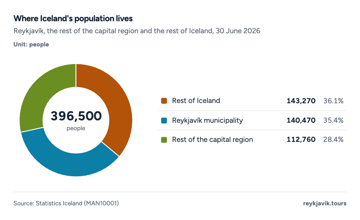
- Reykjavík municipality has 140,470 residents.
- The rest of the capital region has 112,760.
- 143,270 people live outside the capital region.
Top 10 biggest cities in Iceland
Ranked by municipality on 1 January 2026, Reykjavík leads with 139,8045 residents, followed by Kópavogur with 40,2865 and Hafnarfjörður with 32,3985. Reykjanesbær is fourth with 22,6975, ahead of Garðabær (20,7245) and Akureyri (20,2845), the largest municipality in the north. Mosfellsbær, Árborg, Akranes and Múlaþing complete the top 10.
Five of the ten largest municipalities are in the capital region. Only 85 of Iceland's 62 municipalities had 10,000 residents or more, while 265 had fewer than 1,000. The smallest, Tjörneshreppur, had just 545 residents.
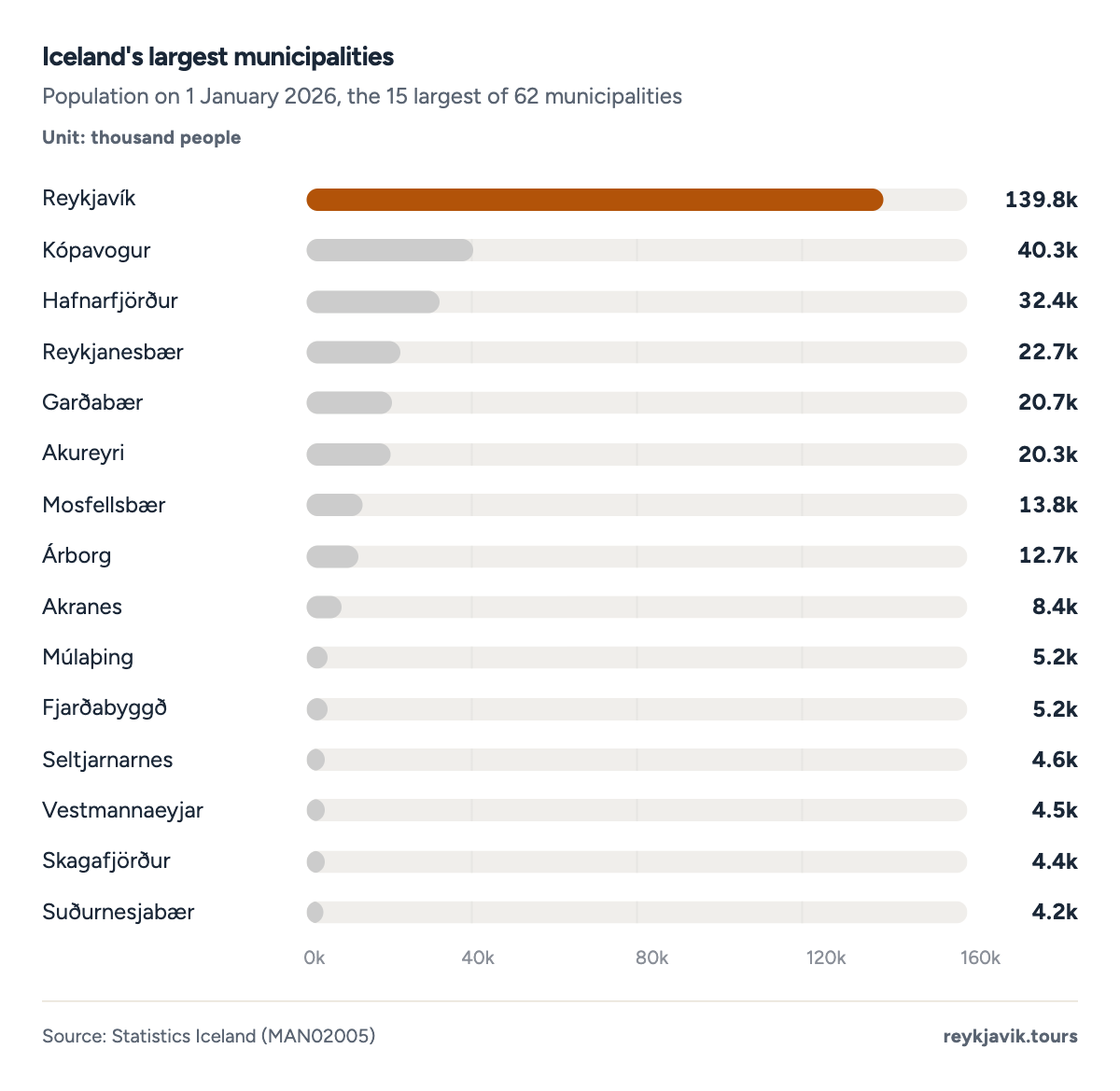
- Reykjavík has 139,804 residents.
- Kópavogur has 40,286.
- Akureyri, sixth, has 20,284.
| 1 | Reykjavík | 139,804 | 35.5 | 119,266 | +17.2 |
| 2 | Kópavogur | 40,286 | 10.2 | 33,537 | +20.1 |
| 3 | Hafnarfjörður | 32,398 | 8.2 | 27,696 | +17.0 |
| 4 | Reykjanesbær | 22,697 | 5.8 | 14,942 | +51.9 |
| 5 | Garðabær | 20,724 | 5.3 | 14,442 | +43.5 |
| 6 | Akureyri | 20,284 | 5.1 | 18,118 | +12.0 |
| 7 | Mosfellsbær | 13,772 | 3.5 | 9,338 | +47.5 |
| 8 | Árborg | 12,671 | 3.2 | 8,108 | +56.3 |
| 9 | Akranes | 8,440 | 2.1 | 6,841 | +23.4 |
| 10 | Múlaþing | 5,235 | 1.3 | 4,636 | +12.9 |
| 11 | Fjarðabyggð | 5,228 | 1.3 | 4,807 | +8.8 |
| 12 | Seltjarnarnes | 4,609 | 1.2 | 4,319 | +6.7 |
| 13 | Vestmannaeyjar | 4,518 | 1.1 | 4,232 | +6.8 |
| 14 | Skagafjörður | 4,361 | 1.1 | 4,057 | +7.5 |
| 15 | Suðurnesjabær | 4,232 | 1.1 | 2,959 | +43.0 |
| 16 | Borgarbyggð | 4,082 | 1.0 | 3,580 | +14.0 |
| 17 | Ísafjarðarbær | 3,987 | 1.0 | 3,552 | +12.2 |
| 18 | Hveragerði | 3,344 | 0.8 | 2,422 | +38.1 |
| 19 | Norðurþing | 3,017 | 0.8 | 2,784 | +8.4 |
| 20 | Ölfus | 2,907 | 0.7 | 1,909 | +52.3 |
Biggest towns in Iceland
A municipality can hold several towns, and one town can spread over several municipalities, so the list of localities looks different. Greater Reykjavík, with 247,1623 people, is about 11 times3 the size of the next urban area, Keflavík and Njarðvík (22,5723). Akureyri follows with 20,4673, then Selfoss with 11,0663 and Akranes with 8,6073. Vestmannaeyjar is sixth with 4,5183.
Only 43 localities have 10,000 residents or more. Below Akranes the sizes drop quickly: the tenth-largest town, Egilsstaðir, has 2,7193 people, and the twentieth, Reyðarfjörður, 1,4703.
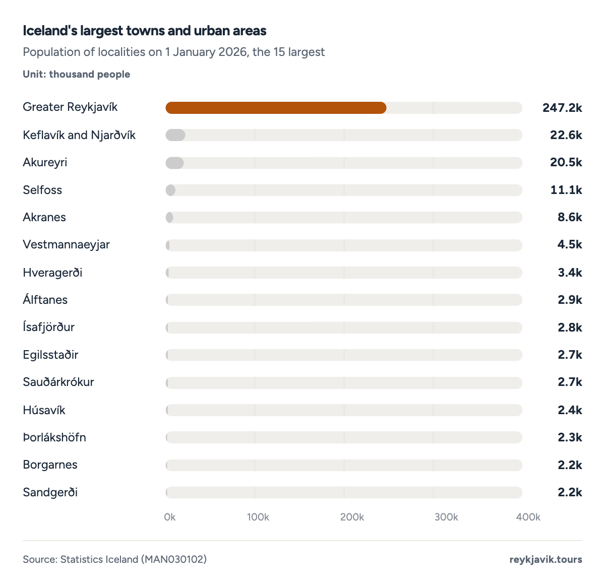
- Greater Reykjavík has 247,162 people.
- Keflavík and Njarðvík has 22,572.
- Akureyri has 20,467.
| 1 | Greater Reykjavík | 247,162 | 62.7 | 204,825 | +20.7 |
| 2 | Keflavík and Njarðvík | 22,572 | 5.7 | 14,841 | +52.1 |
| 3 | Akureyri | 20,467 | 5.2 | 17,974 | +13.9 |
| 4 | Selfoss | 11,066 | 2.8 | 6,881 | +60.8 |
| 5 | Akranes | 8,607 | 2.2 | 6,894 | +24.8 |
| 6 | Vestmannaeyjar | 4,518 | 1.1 | 4,232 | +6.8 |
| 7 | Hveragerði | 3,353 | 0.9 | 2,433 | +37.8 |
| 8 | Álftanes | 2,916 | 0.7 | 2,437 | +19.7 |
| 9 | Ísafjörður | 2,807 | 0.7 | 2,506 | +12.0 |
| 10 | Egilsstaðir | 2,719 | 0.7 | 2,293 | +18.6 |
| 11 | Sauðárkrókur | 2,672 | 0.7 | 2,532 | +5.5 |
| 12 | Húsavík | 2,403 | 0.6 | 2,161 | +11.2 |
| 13 | Þorlákshöfn | 2,316 | 0.6 | 1,468 | +57.8 |
| 14 | Borgarnes | 2,250 | 0.6 | 1,872 | +20.2 |
| 15 | Sandgerði | 2,188 | 0.6 | 1,505 | +45.4 |
| 16 | Garður | 2,006 | 0.5 | 1,414 | +41.9 |
| 17 | Vogar | 1,818 | 0.5 | 1,056 | +72.2 |
| 18 | Höfn | 1,813 | 0.5 | 1,641 | +10.5 |
| 19 | Neskaupstaður | 1,478 | 0.4 | 1,423 | +3.9 |
| 20 | Reyðarfjörður | 1,470 | 0.4 | 1,175 | +25.1 |
Statistics Iceland also splits Greater Reykjavík into its urban nuclei, one per municipality. On that basis the town of Reykjavík had 138,7533 residents, Kópavogur 40,2283 and Hafnarfjörður 32,3983, so three of Iceland's four largest urban places touch each other on the map.
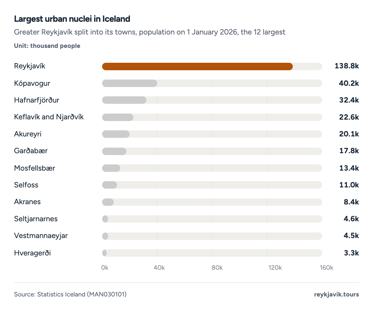
- The town of Reykjavík has 138,753 residents.
- Kópavogur has 40,228.
- Hafnarfjörður has 32,398.
Second biggest city in Iceland
The answer depends on the measure again. As a municipality, Kópavogur has been in second place in every year since at least 1998, when it had 19,8675 residents; at the end of June 2026 it had 40,2402. Hafnarfjörður is third with 32,8102. Both are part of the Greater Reykjavík urban area, so neither is a separate town on the map.
Outside the capital region, the title has changed hands. In 2016 Akureyri, the largest town in the north, still had 17,9743 residents against 14,8413 in Keflavík and Njarðvík. The airport town grew by 52.1%3 in ten years and overtook Akureyri in 2022. Among municipalities, Reykjanesbær passed Akureyri in the same year, and Garðabær passed it in 2025, pushing Akureyri down to sixth place.
- Kópavogur
- Hafnarfjörður
- Reykjanesbær
- Akureyri
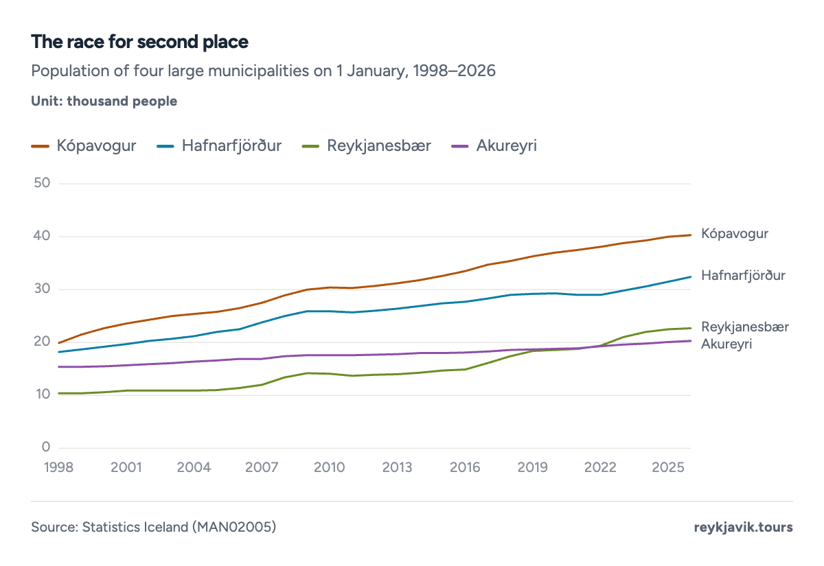
- Kópavogur reached 40,286 in 2026.
- Reykjanesbær grew from 10,405 in 1998 to 22,697.
- Akureyri had 20,284 in 2026.
| Municipality (30 June 2026) | Reykjavík 140,470 | Kópavogur 40,240 | Hafnarfjörður 32,810 |
| Urban area (1 Jan. 2026) | Greater Reykjavík 247,162 | Keflavík and Njarðvík 22,572 | Akureyri 20,467 |
| Urban nucleus (1 Jan. 2026) | Reykjavík 138,753 | Kópavogur 40,228 | Hafnarfjörður 32,398 |
| Municipality outside the capital region | Reykjanesbær 22,660 | Akureyri 20,330 | Árborg 12,671 |
So if Reykjavík is the only real city, how many cities and towns does the rest of Iceland add up to?
How many cities in Iceland are there?
Counted by local government, Iceland had 625 municipalities on 1 January 2026. After the local elections of 16 May 2026 the number fell to 616, when Borgarbyggð and Skorradalshreppur were counted as one in Statistics Iceland's quarterly table.2 Several carry the word for town (bær or kaupstaður) in their names, such as Kópavogsbær and Hafnarfjarðarkaupstaður.5
The number has shrunk through mergers. There were 1737 municipalities in 1875 and, most likely, a peak of 2298 in 1950. Few changes came until a 1986 law allowed small municipalities to be merged; in 1986 there were 2238, by 1998 1248, and by 2006 798. Since 1950 Iceland has lost 1686 municipalities.
| 1875 | 173 | Byggðastofnun |
| 1950 | 229 | Government of Iceland (2014) |
| 1986 | 223 | Government of Iceland (2014) |
| 1990 | 204 | Government of Iceland (2014) |
| 1998 | 124 | Government of Iceland (2014) |
| 2000 | 124 | Government of Iceland (2014) |
| 2006 | 79 | Government of Iceland (2014) |
| 2010 | 76 | Government of Iceland (2014) |
| 2014 | 74 | Government of Iceland (2014) |
| 1 Jan. 2026 | 62 | Statistics Iceland |
| After 16 May 2026 | 61 | Association of Local Authorities |
How many towns in Iceland
Statistics Iceland counts a locality as urban when at least 200 people live there. By that rule Iceland had 673 towns and villages on 1 January 2026: 13 with over 100,000 people (Greater Reykjavík), 33 with 10,000–99,999, 223 with 1,000–9,999 and 413 villages with 200–999. Another 373 clusters of 50–199 people are listed but counted as rural.
The towns hold most of the population. Greater Reykjavík alone has 62.7%3, the three towns of 10,000–99,999 another 13.7%3, and only 5.5%3 of people live in rural areas or in clusters under 200. The number of urban localities has barely moved: 643 in 1998 and 67 in 2026. Because the count dipped to 58 in 2012 before rising again, a straight line through 1998–2026 points to only about 63 by 2050, our calculation rather than a forecast; population growth has gone mostly into existing towns rather than new ones.
- Greater Reykjavík (100,000+)247,16262.7%
- Towns of 10,000–99,99954,10513.7%
- Towns of 1,000–9,99952,42313.3%
- Other: villages under 1,000 and rural areas40,63410.3%
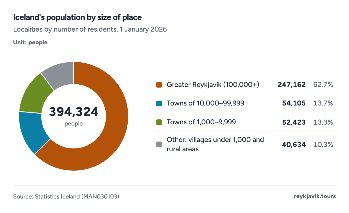
- Greater Reykjavík holds 62.7% of the population.
- Towns of 1,000–9,999 hold 52,423 people.
Projection: linear trend of 1998–2026 yearly values, 95% prediction range. Our calculation, not a forecast.
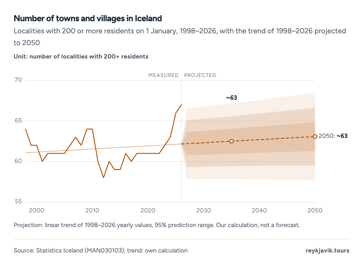
- There were 64 towns and villages in 1998.
- There were 67 in 2026.
| 100,000 and over | 1 | 247,162 | 62.7 |
| 10,000–99,999 | 3 | 54,105 | 13.7 |
| 5,000–9,999 | 1 | 8,607 | 2.2 |
| 2,000–4,999 | 11 | 30,148 | 7.6 |
| 1,000–1,999 | 10 | 13,668 | 3.5 |
| 500–999 | 16 | 11,455 | 2.9 |
| 300–499 | 9 | 3,443 | 0.9 |
| 200–299 | 16 | 4,028 | 1.0 |
| 100–199 (rural) | 19 | 2,626 | 0.7 |
| 50–99 (rural) | 18 | 1,323 | 0.3 |
| Other rural areas | - | 17,759 | 4.5 |
Smallest town in Iceland
Among places large enough to count as urban, the smallest was Kirkjubæjarklaustur, with 2103 residents on 1 January 2026. The smallest locality that Statistics Iceland lists at all is Grímsey, with 473 people, down from 693 in 2016. Several of the tiny places in the table were not listed in 2016 because they had fewer than 50 residents then.
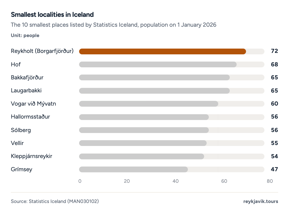
- Grímsey has 47 residents.
- Kleppjárnsreykir has 54.
| 1 | Grímsey | 47 | 69 |
| 2 | Kleppjárnsreykir | 54 | 47 |
| 3 | Vellir | 55 | - |
| 4 | Hallormsstaður | 56 | - |
| 5 | Sólberg | 56 | - |
| 6 | Vogar við Mývatn | 60 | - |
| 7 | Bakkafjörður | 65 | 83 |
| 8 | Laugarbakki | 65 | - |
| 9 | Hof | 68 | - |
| 10 | Reykholt (Borgarfjörður) | 72 | - |
| 11 | Árnes | 74 | - |
| 12 | Veigastaðir | 74 | - |
How Reykjavík grew
The census of 1 November 1901 counted 6,6671 people in Reykjavík, 8.5%1 of Iceland. The town grew fast in the first half of the century: 28,3041 in 1930 and 56,2511 in 1950. Reykjavík passed 100,000 residents in 19921 and had 139,8045 on 1 January 2026, 21 times as many as in 1901.
Since 2000 the municipality has added about 1,0065 people a year on average. Drawn forward, that straight line reaches about 158,0005 residents in 2050, our calculation rather than a forecast. The trend hides a dip: the population fell from 119,5475 in 2009 to 115,3945 in 2011, then grew by 20,5385 in the last ten years.
Projection: linear trend of 2000–2026 per-decade values, 95% prediction range. Our calculation, not a forecast.
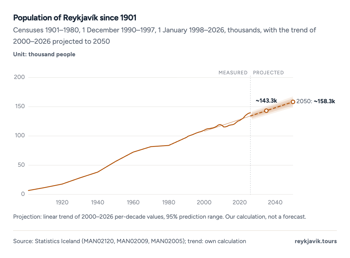
- Reykjavík had 6,667 residents in 1901.
- It had 139,804 in 2026.
Reykjavík's share of Iceland peaked at 40.8%1 in the census of 1960. Since 1998 it has slipped from 39.4%5 to 35.5%5, because the suburbs and the towns within commuting distance grew faster. If the trend of 2000–2026 continued, Reykjavík's share would fall to about 31.2%5 by 2050. The capital region as a whole moved the other way, from 60.4%5 of the population in 1998 to 63.9%5 in 2026.
Projection: linear trend of 2000–2026 per-decade values, 95% prediction range. Our calculation, not a forecast.
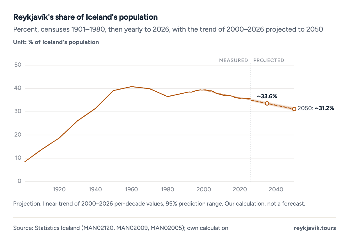
- The share peaked at 40.8% in 1960.
- It was 35.5% in 2026.
| 1901 | 6,667 | 78,470 | 8.5 | 1 November census |
| 1910 | 11,600 | 85,183 | 13.6 | 1 December census |
| 1920 | 17,679 | 94,690 | 18.7 | 1 December census |
| 1930 | 28,304 | 108,861 | 26.0 | 2 December census |
| 1940 | 38,196 | 121,474 | 31.4 | 2 December census |
| 1950 | 56,251 | 143,973 | 39.1 | 1 December census |
| 1960 | 72,407 | 177,292 | 40.8 | 1 December census |
| 1970 | 81,693 | 204,578 | 39.9 | 1 December census |
| 1980 | 83,766 | 229,187 | 36.5 | 1 December census |
| 1990 | 97,569 | 255,708 | 38.2 | 1 December |
| 2000 | 109,887 | 279,049 | 39.4 | 1 January |
| 2010 | 118,326 | 317,630 | 37.3 | 1 January |
| 2020 | 126,549 | 354,042 | 35.7 | 1 January |
| 2026 | 139,804 | 394,324 | 35.5 | 1 January |
- Capital region
- Rest of Iceland
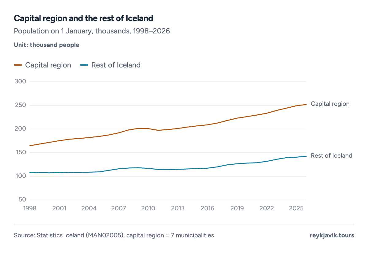
- The capital region had 251,912 people in 2026.
- The rest of Iceland had 142,412.
Where Iceland is growing fastest
Between 1 January 2016 and 2026, Iceland's population grew by 20.9%5. Reykjavík grew more slowly, by 17.2%5, while the rest of the capital region pushed the region's growth to 20.6%5. Outside the capital region, population rose by 21.5%5.
The fastest growth came outside the capital region. Among municipalities with at least 1,000 residents in 2016, Vogar grew by 67.3%5, Árborg by 56.3%5, Ölfus by 52.3%5 and Reykjanesbær by 51.9%5. In the capital region, Mosfellsbær (47.5%5) and Garðabær (43.5%5) grew much faster than Reykjavík. On the south coast, the village of Vík grew from 3183 to 7403 residents.
One town went sharply the other way. Grindavík on the Reykjanes Peninsula had 3,5753 registered residents on 1 January 2024 and 8173 on 1 January 2026, a fall of 77% in two years.
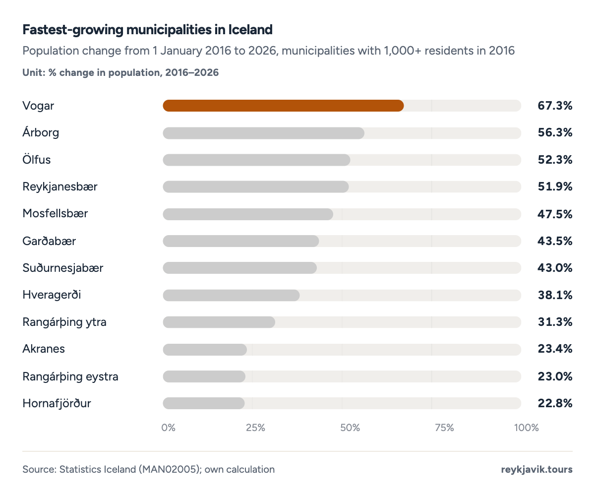
- Vogar grew by 67.3%.
- Reykjanesbær grew by 51.9%.
Inside Reykjavík: the districts
Reykjavík is divided into ten districts. The largest, Breiðholt, had 22,2839 residents on 1 January 2026, almost exactly as many as in 1998 (22,2349). Laugardalur (19,5149) and Grafarvogur (18,3589) follow. The city centre, Miðborg, has 10,9999 residents after growing 40.8%9 since 2016.
The fastest-built district shows how the city has expanded outward. Grafarholt-Úlfarsárdalur had only 729 residents in 1998 and 8,8849 in 2026. Kjalarnes, which joined Reykjavík in 1998,1 is the smallest district with 1,0089. Another 1,9189 residents were registered without a district.
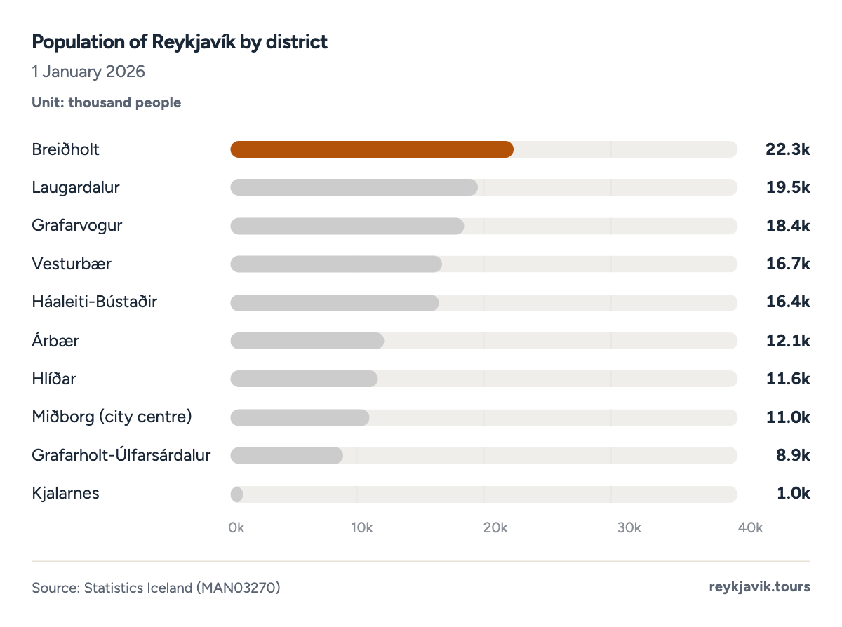
- Breiðholt has 22,283 residents.
- Miðborg, the city centre, has 10,999.
- Kjalarnes has 1,008.
| 1 | Breiðholt | 22,283 | 15.9 | 20,845 | +6.9 | 22,234 |
| 2 | Laugardalur | 19,514 | 14.0 | 15,587 | +25.2 | 14,564 |
| 3 | Grafarvogur | 18,358 | 13.1 | 17,613 | +4.2 | 13,912 |
| 4 | Vesturbær | 16,658 | 11.9 | 15,376 | +8.3 | 15,564 |
| 5 | Háaleiti-Bústaðir | 16,407 | 11.7 | 14,034 | +16.9 | 14,084 |
| 6 | Árbær | 12,139 | 8.7 | 10,773 | +12.7 | 8,647 |
| 7 | Hlíðar | 11,636 | 8.3 | 9,736 | +19.5 | 9,235 |
| 8 | Miðborg (city centre) | 10,999 | 7.9 | 7,811 | +40.8 | 8,177 |
| 9 | Grafarholt-Úlfarsárdalur | 8,884 | 6.4 | 6,335 | +40.2 | 72 |
| 10 | Kjalarnes | 1,008 | 0.7 | 880 | +14.5 | 592 |
Area and density of the capital region
Reykjavík's 273 km²10 (105 sq mi) make it a spacious city: with 139,804 residents it has about 1,326105 people per square mile, or 512 per km². Kópavogur, on 80 km²10 (31 sq mi), is almost as dense. The densest municipality is Seltjarnarnes, with 2 km²10 (0.8 sq mi) with about 5,969105 people per square mile. Kjósarhreppur covers 284 km²10 with only 319 residents.
The municipal areas listed by the University of Iceland's science web add up to about 1,043 km² (about 403 sq mi), roughly 1% of Iceland, which puts the whole capital region at about 626105 people per square mile.
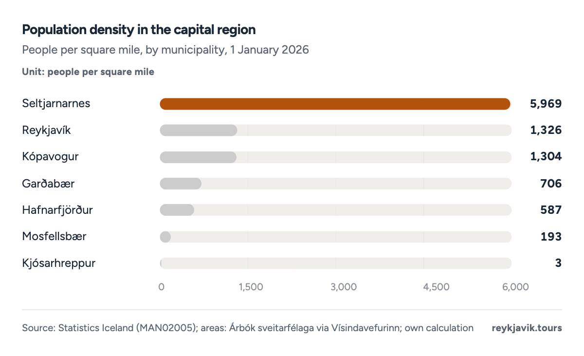
- Seltjarnarnes has 5,969 people per square mile.
- Reykjavík has 1,326.
| 1 | Seltjarnarnes | 0.8 | 2 | 4,609 | 5,969 | 2,304 |
| 2 | Reykjavík | 105.4 | 273 | 139,804 | 1,326 | 512 |
| 3 | Kópavogur | 30.9 | 80 | 40,286 | 1,304 | 504 |
| 4 | Garðabær | 29.3 | 76 | 20,724 | 706 | 273 |
| 5 | Hafnarfjörður | 55.2 | 143 | 32,398 | 587 | 227 |
| 6 | Mosfellsbær | 71.4 | 185 | 13,772 | 193 | 74 |
| 7 | Kjósarhreppur | 109.7 | 284 | 319 | 3 | 1 |
Who lives in Iceland's biggest city
Reykjavík has more people of working age, and fewer children and older people, than the rest of the country. On 1 January 2026, people in their thirties made up 17.2%5 of Reykjavík's residents against 14.8%5 elsewhere in Iceland. Children under 15 were 16.3%5 of the city against 18.2% outside it, and people aged 65 and over 15.3%5 against 16.6%. The city had 71,0965 male and 68,5875 female residents.
- Working age (15–64)95,64468.4%
- Children (0–14)22,79716.3%
- 65 and older21,36315.3%
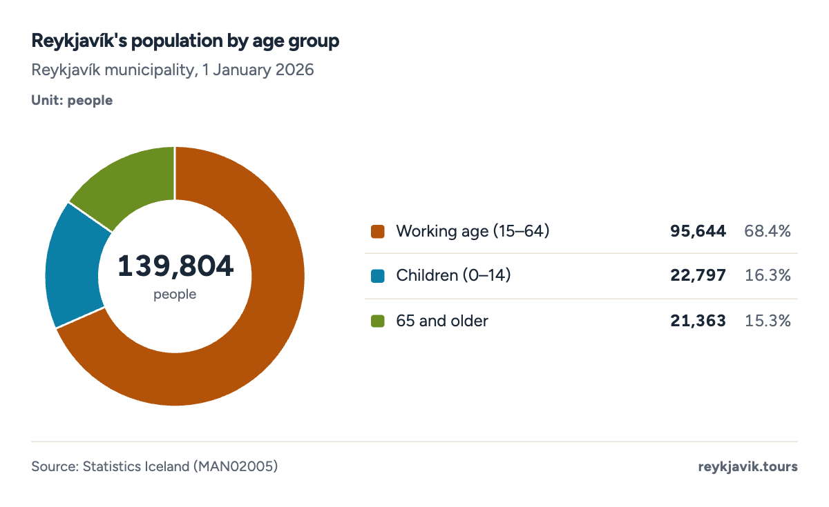
- 68.4% of residents are aged 15–64.
- 15.3% are 65 or older.
- Reykjavík
- Rest of Iceland
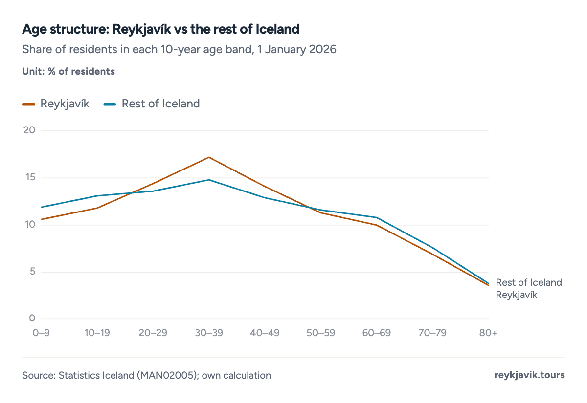
- People aged 30–39 are 17.2% of Reykjavík.
- They are 14.8% of the rest of Iceland.
Reykjavík also has the highest share of foreign citizens among the capital region's large municipalities. At the end of June 2026, 30,4102 foreign citizens lived in the city, 21.6%2 of its residents, up from 7.1%2 at the end of 2010. The national figure was 17.9%2. Among the 15 largest municipalities the highest share is in Reykjanesbær, at 30.1%2, and the lowest in Garðabær, at 7.7%2.
- Reykjavík
- Capital region
- Outside the capital region
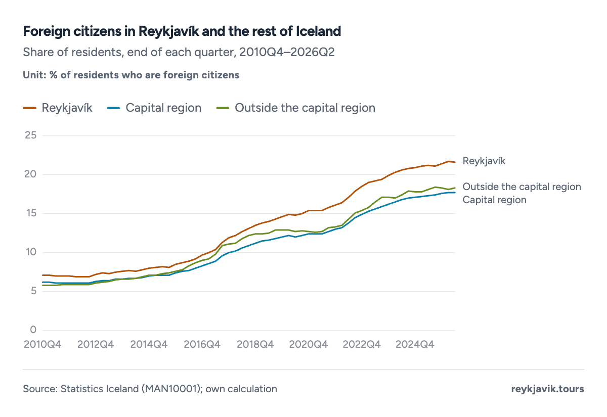
- Reykjavík reached 21.6% in 2026Q2.
- Outside the capital region the share was 18.3%.
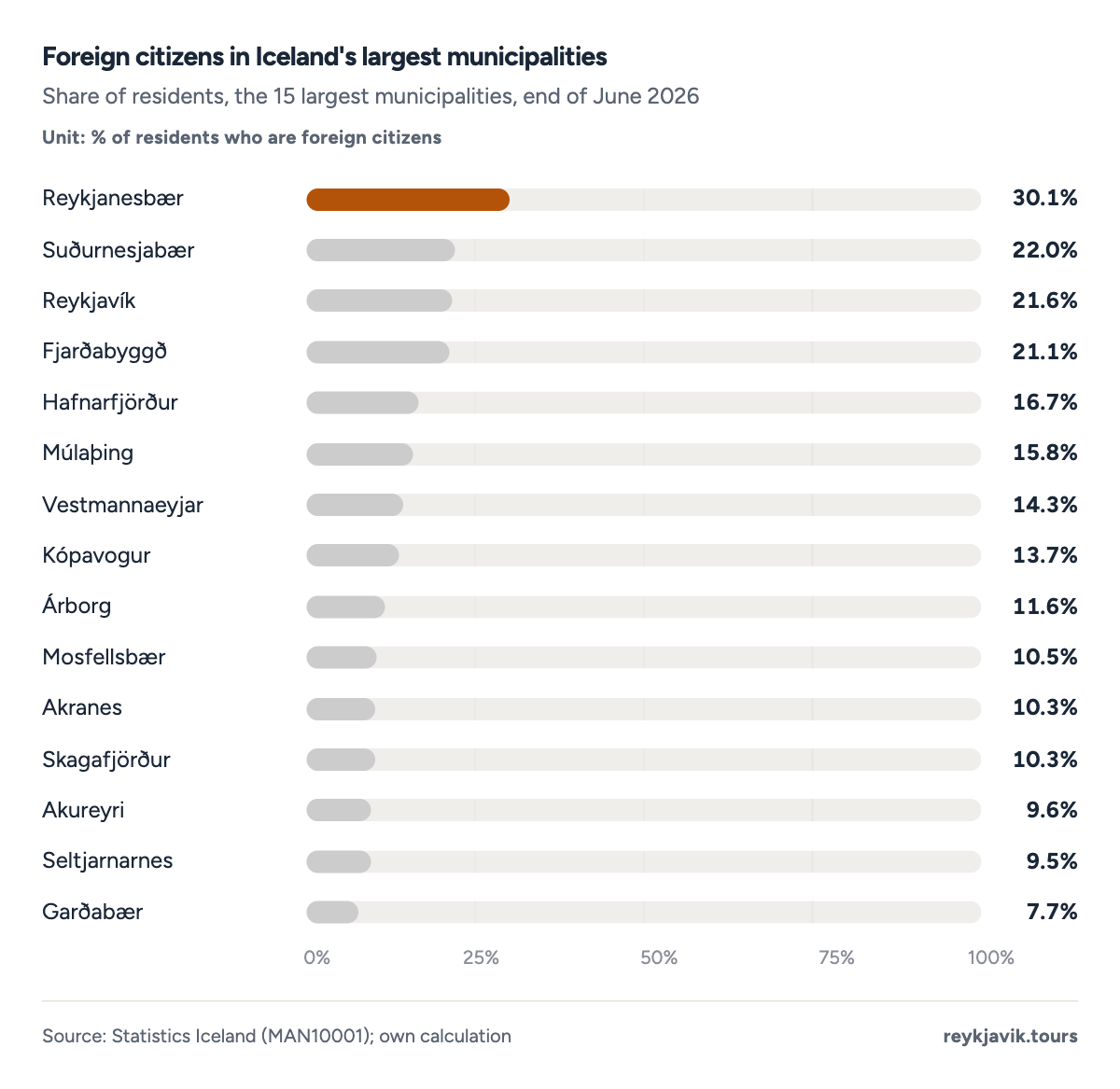
- Reykjanesbær has the highest share, 30.1%.
- Reykjavík's share is 21.6%.
| 1 | Reykjanesbær | 6,830 | 22,660 | 30.1 |
| 2 | Suðurnesjabær | 940 | 4,270 | 22.0 |
| 3 | Reykjavík | 30,410 | 140,470 | 21.6 |
| 4 | Fjarðabyggð | 1,110 | 5,260 | 21.1 |
| 5 | Hafnarfjörður | 5,480 | 32,810 | 16.7 |
| 6 | Múlaþing | 830 | 5,260 | 15.8 |
| 7 | Vestmannaeyjar | 650 | 4,550 | 14.3 |
| 8 | Kópavogur | 5,500 | 40,240 | 13.7 |
| 9 | Árborg | 1,490 | 12,830 | 11.6 |
| 10 | Mosfellsbær | 1,450 | 13,820 | 10.5 |
| 11 | Akranes | 870 | 8,470 | 10.3 |
| 12 | Skagafjörður | 450 | 4,370 | 10.3 |
| 13 | Akureyri | 1,960 | 20,330 | 9.6 |
| 14 | Seltjarnarnes | 440 | 4,630 | 9.5 |
| 15 | Garðabær | 1,620 | 20,940 | 7.7 |
Statistics Iceland's degree-of-urbanisation table gives one more view of city life. In 2026, 63.8%11 of Iceland's population lived in densely populated areas, 16.3%11 in intermediate areas and 19.9%11 in thinly populated areas. The dense share has barely changed since 2010 (63.2%), while intermediate areas gained.
- Densely populated
- Intermediate
- Thinly populated
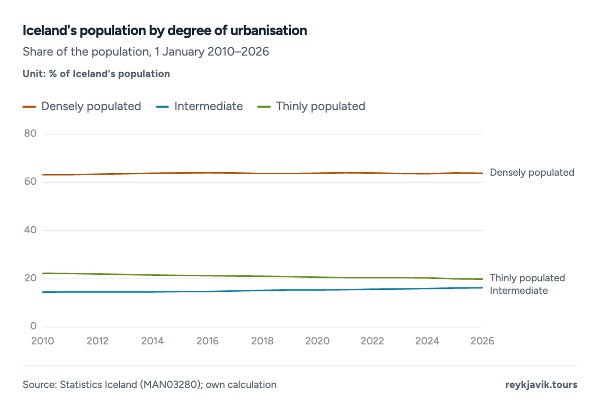
- Densely populated areas held 63.8% in 2026.
- Thinly populated areas held 19.9%.
From a single city to a whole region of Europe: how big is Reykjavík next to the other Nordic capitals?
Reykjavík among the Nordic capitals
Nordic Statistics compares the capital areas of the Nordic countries using each national office's own definition; for Iceland it is the capital region. In 2025 the Reykjavík capital area had 249,05412 residents, about a tenth of Stockholm's 2,473,30712 and a sixth of Oslo's 1,464,97012. Copenhagen had 1,396,50812 and Helsinki 1,266,47112.
Reykjavík is small but fast. From 2011 to 2025 its capital area grew by 26.2%12, the fastest of the eight capital areas, ahead of Nuuk (25.5%12) and Oslo (23.2%12). Tórshavn in the Faroe Islands, Nuuk in Greenland and Mariehamn in Åland are the only smaller Nordic capitals.
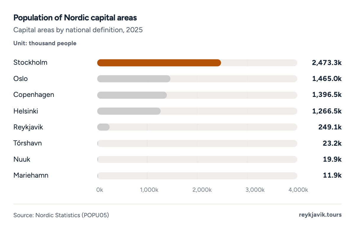
- Stockholm's capital area has 2,473,307 people.
- Reykjavik's has 249,054.
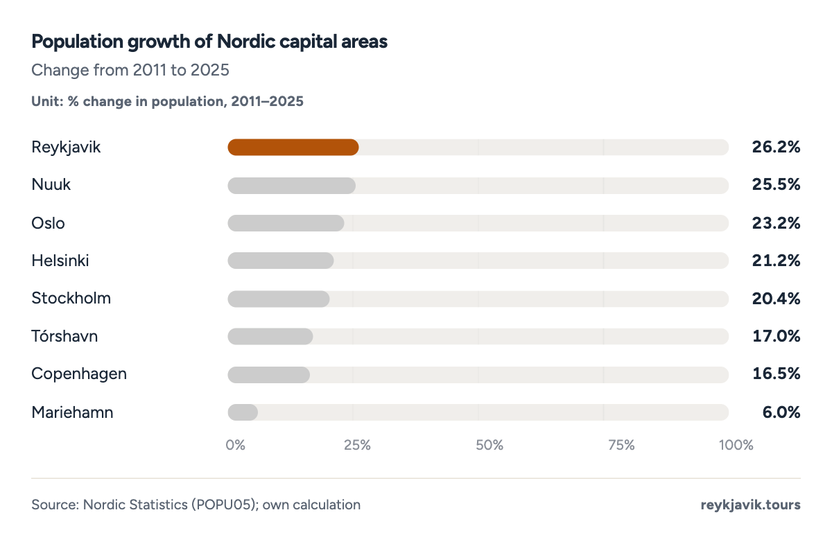
- Reykjavik's capital area grew 26.2%.
- Mariehamn grew 6.0%.
| 1 | Stockholm | Sweden | 2,473,307 | 2,054,343 | +20.4 |
| 2 | Oslo | Norway | 1,464,970 | 1,188,993 | +23.2 |
| 3 | Copenhagen | Denmark | 1,396,508 | 1,199,224 | +16.5 |
| 4 | Helsinki | Finland | 1,266,471 | 1,045,263 | +21.2 |
| 5 | Reykjavik | Iceland | 249,054 | 197,322 | +26.2 |
| 6 | Tórshavn | Faroe Islands | 23,239 | 19,866 | +17.0 |
| 7 | Nuuk | Greenland | 19,903 | 15,862 | +25.5 |
| 8 | Mariehamn | Åland | 11,866 | 11,190 | +6.0 |
The biggest buildings in Iceland's capital
Biggest church in Reykjavik
Hallgrímskirkja, the Lutheran parish church on Skólavörðuholt hill, describes itself as the largest church in Iceland.13 Its tower rises 244 feet (74.5 m)14. Designed by Guðjón Samúelsson, it took decades to build: construction began in 194515, the steeple and wings were consecrated in 197415 and the nave was completed in 198615. Iceland Magazine reported in 2018 that the church was the tallest building in Reykjavík and the second-tallest building in Iceland.15
The tallest building in the country is not in Reykjavík at all. According to the same 2018 report, the Smáratorg tower next to the Smáralind shopping centre in Kópavogur measures 255 feet (77.6 m)15, about 10 feet (3.1 m) more than Hallgrímskirkja, and a smokestack at the aluminium smelter in Reyðarfjörður, East Iceland, reaches 256 feet (78 m)15.
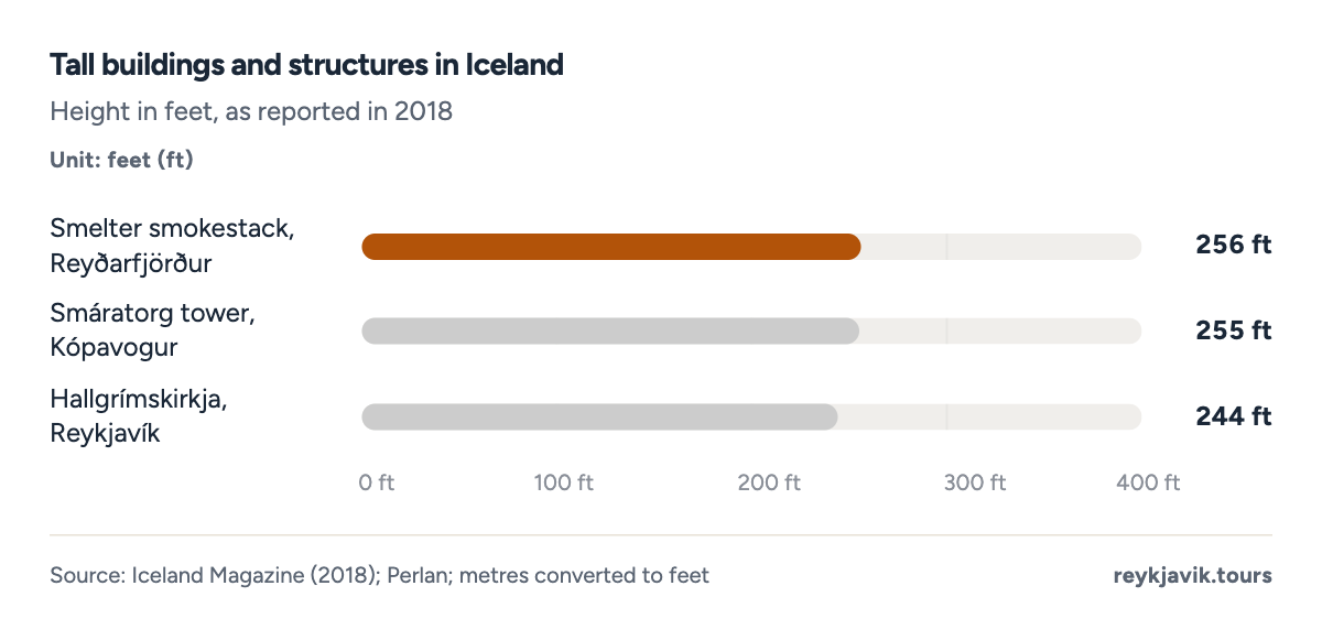
- Hallgrímskirkja is 244 ft tall.
- The Smáratorg tower is 255 ft.
Biggest mall in Iceland
Smáralind in Kópavogur calls itself the largest shopping centre in Iceland, with more than 667,000 sq ft (62,000 m²)16 of shops, restaurants, services and entertainment and nearly 3,00016 parking spaces. It opened on 10 October 200117, and at 61,500 m² it was then the largest building in Iceland.17
The biggest mall in Reykjavik itself is Kringlan, which describes itself as the city's largest shopping centre.18 It opened in 198718 with about 301,000 sq ft (28,000 m²)19 and had grown to about 570,000 sq ft (53,000 m²)19 by 2017. Today it has more than 15018 shops, restaurants and service businesses and over 1,80018 parking spaces.
| Largest church in Iceland | Hallgrímskirkja, Reykjavík | 244 ft tall | 74.5 m | Hallgrímskirkja; Perlan |
| Tallest building in Iceland (2018) | Smáratorg tower, Kópavogur | 255 ft tall | 77.6 m | Iceland Magazine |
| Largest shopping centre in Iceland | Smáralind, Kópavogur | 667,000+ sq ft | 62,000+ m² | Smáralind |
| Largest shopping centre in Reykjavík | Kringlan, Reykjavík | 570,000 sq ft (2017) | 53,000 m² | Kringlan; Vísir |
| Largest building in Iceland at opening (2001) | Smáralind, Kópavogur | 662,000 sq ft | 61,500 m² | Ísat |
What the numbers mean
For a country of about 396,500 people, Iceland has a dominant capital. With 63.9% of residents in the capital region and 62.7% in one continuous urban area, Greater Reykjavík is about 11 times the size of the next urban area, and 5 of the 10 largest municipalities lie in the capital region.
That dominance is not growing inside Reykjavík's own borders. The municipality's share of Iceland has fallen from 39.4% in 1998 to 35.5% today, while nearby municipalities such as Vogar, Árborg and Ölfus grew by more than half in ten years. The practical result is a capital that spreads: new districts such as Grafarholt-Úlfarsárdalur, suburbs that overtake old regional centres, and a population that is younger, more international and more likely to be in its thirties than the rest of the country.
Conclusions
- Reykjavík is the biggest city by every measure, but the size depends on the border. The municipality has 140,470 residents, the continuous urban area 247,162 and the capital region 253,230, a gap of more than 100,000 people between the narrowest and widest definition.
- The second-biggest place is really a suburb. Kópavogur and Hafnarfjörður are separate municipalities but part of the same urban area; the largest separate town, Keflavík and Njarðvík, passed Akureyri only in 2022, driven by growth of 52.1% in ten years.
- Iceland has few cities and many small towns. There are 62 municipalities and 67 towns and villages, yet only 4 places have more than 10,000 people, and the number of urban localities has barely changed since 1998.
- Growth is moving to the edge of the capital. Reykjavík grew 17.2% in ten years against 20.9% for Iceland, and its capital area was still the fastest-growing in the Nordic region from 2011 to 2025 at 26.2%, so the wider region, not the old city, absorbs the new residents.
Methodology
- Population 1901–2026
- 62 municipalities, 105 listed localities
- Trend to 2050
- Checked Sept 16, 2026
Definition. Iceland has no legal city status. A municipality (sveitarfélag) is a unit of local government; a locality (þéttbýli) is a built-up area where Statistics Iceland counts at least 200 residents as urban, while smaller clusters count as rural. The capital region is the seven municipalities of Reykjavík, Kópavogur, Hafnarfjörður, Garðabær, Mosfellsbær, Seltjarnarnes and Kjósarhreppur.
Data sources. Population by municipality, quarter, locality, district and degree of urbanisation from Statistics Iceland's PX tables;2 historical census figures from Statistics Iceland;1 Nordic capital areas from Nordic Statistics;12 numbers of municipalities from the Association of Local Authorities,6 the Government of Iceland8 and Byggðastofnun;7 areas from the University of Iceland's science web;10 building sizes from the operators' websites,16 Iceland Magazine15 and Vísir.19
Calculations. The Reykjavík series joins censuses (1901–1980), 1 December counts (1990–1997) and 1 January counts on current boundaries (1998–2026). Shares, growth rates, age bands and densities are our calculations from Statistics Iceland's counts. Trend projections are least-squares lines with a 95% prediction range, fitted from 2000 (Reykjavík population and share) and 1998 (number of towns). Metres and square metres are converted to feet (×3.281) and square feet (×10.764); km² to square miles (÷2.590).
Limitations. Counting dates differ between tables (end of quarter vs 1 January), so figures for the same place differ slightly. Kjalarnes joined Reykjavík in 1998, which adds about 600 people to the series from that year. The capital-region areas are from 2021 and add up to 1,043 km², while the source text rounds the total to just over 1,007 km². Building heights date from 2018; mall floor areas are the operators' own figures. No sourced figures were found for the largest supermarket or current stadium capacity, so they are not included.
Sources
- Statistics Iceland (Hagstofa Íslands). “Population by municipality: censuses 1901–1990 (MAN02120) and 1 December 1990–2004 (MAN02009).” Statistics Iceland. px.hagstofa.is. Accessed 16 Sept. 2026. Back to text
- Statistics Iceland (Hagstofa Íslands). “Population by municipality, sex, citizenship and quarters 2010–2026 (MAN10001).” Statistics Iceland, 31 July 2026. px.hagstofa.is. Accessed 16 Sept. 2026. Back to text
- Statistics Iceland (Hagstofa Íslands). “Population by localities (MAN030102), urban nuclei (MAN030101) and size of localities (MAN030103) 1998–2026.” Statistics Iceland. px.hagstofa.is. Accessed 16 Sept. 2026. Back to text
- Vísindavefurinn (EDS). “Hvað er Reykjavík stór? (How big is Reykjavík?).” Vísindavefurinn, University of Iceland, 26 Mar. 2004, updated 27 July 2022. visindavefur.is. Accessed 16 Sept. 2026. Back to text
- Statistics Iceland (Hagstofa Íslands). “Population by municipality, age and sex 1998–2026, current municipalities (MAN02005).” Statistics Iceland. px.hagstofa.is. Accessed 16 Sept. 2026. Back to text
- Samband íslenskra sveitarfélaga (Icelandic Association of Local Authorities). “Nánar um sveitarfélögin (About the municipalities).” Samband íslenskra sveitarfélaga. samband.is. Accessed 16 Sept. 2026. Back to text
- Byggðastofnun (Icelandic Regional Development Institute). “Sveitarfélagaskipan frá 1875 (Municipal divisions since 1875), dashboard.” Byggðastofnun. byggdastofnun.is. Accessed 16 Sept. 2026. Back to text
- Ministry of the Interior (Innanríkisráðuneytið). “Fjöldi sveitarfélaga (Number of municipalities).” Government of Iceland (Stjórnarráð Íslands), 23 Apr. 2014. stjornarradid.is. Accessed 16 Sept. 2026. Back to text
- Statistics Iceland (Hagstofa Íslands). “Population in Reykjavík by districts 1998–2026 (MAN03270).” Statistics Iceland. px.hagstofa.is. Accessed 16 Sept. 2026. Back to text
- Sveinbjörnsdóttir, Emilía Dagný. “Hvað er Stór-Reykjavíkursvæðið stórt sem hlutfall af öllu landinu? (areas from Árbók sveitarfélaga 2021).” Vísindavefurinn, University of Iceland, 28 Mar. 2002, updated 27 July 2022. visindavefur.is. Accessed 16 Sept. 2026. Back to text
- Statistics Iceland (Hagstofa Íslands). “Population by degree of urbanisation 2010–2026 (MAN03280).” Statistics Iceland. px.hagstofa.is. Accessed 16 Sept. 2026. Back to text
- Nordic Statistics (Nordic Council of Ministers), from the national statistical offices. “Capital area population by capital name and time (POPU05).” Nordic Statistics database. pxweb.nordicstatistics.org. Accessed 16 Sept. 2026. Back to text
- Hallgrímskirkja. “Hallgrímskirkja (official website).” Hallgrímskirkja parish. hallgrimskirkja.is. Accessed 16 Sept. 2026. Back to text
- Perlan (commercial attraction). “Hallgrímskirkja Church in Reykjavík.” Perlan. perlan.is. Accessed 16 Sept. 2026. Back to text
- Helgason, Magnús Sveinn. “Seven interesting facts about one of Reykjavík's best known landmarks, Hallgrímskirkja church.” Iceland Magazine, 14 Jan. 2018. icelandmag.is. Accessed 16 Sept. 2026. Back to text
- Smáralind (operator). “Um Smáralind (About Smáralind).” Smáralind / Heimar. smaralind.is. Accessed 16 Sept. 2026. Back to text
- Ísat. “Smáralind (company profile).” isat.is (business directory). isat.is. Accessed 16 Sept. 2026. Back to text
- Kringlan (operator). “Upplýsingar (Information).” Kringlan. kringlan.is. Accessed 16 Sept. 2026. Back to text
- Vísir. “Kringlan fagnar 30 árum (Kringlan celebrates 30 years).” Vísir, 12 Aug. 2017. visir.is. Accessed 16 Sept. 2026. Back to text
About the author
Laufey turns public statistics on tourism and travel into research people can check and cite.
Every figure on this page links to its source. How we research
Related research
More data on Iceland's weather and travel from Reykjavik Tours.
- SocietyHow Many People Live in Iceland? (2026 Data)396,500 people living in IcelandRead the research →
- SocietyIceland Ethnic Composition Percentage (2026 Data)70.9% of Iceland's residents have no foreign backgroundRead the research →
- SocietyIceland Average Height for Men and Women (2026 Data)5 ft 11 in average height of young Icelandic menRead the research →
- TravelHow Many Days in Iceland? (2026 Data)7.1 nights average stay of foreign visitorsRead the research →
- WeatherIceland Temperature by Month (2026 Data)39 °F average temperature in IcelandRead the research →
- WeatherIceland Weather by Month (2026 Data)4.5 in rain in September, Iceland's wettest monthRead the research →